 Research Article
Study of the Agro-Industrial Properties of the Soil Cover of the Agjabadi Region in the Example of the Garadolag Administrative Village
ZH Aliyev, Institute of Soil Science and Agrochemistry of ANAS, Baku.
Received Date: September 22, 2020; Published Date: October 05, 2020
Abstract
It is known from the brief nature of the territory of the research district that the date of establishment of Agjabadi district - 08.08.1930 The territory - 1.76 thousand sq.m. km Population - 136.8 thousand people (January 1, 2020) Population density - 1 sq. km. km 78 people (January 1, 2020). Agjabedi district is located in Mil and Garabagh plains of Kur-Araz lowland. Agjabedi city and Sarvanlar, Kurds, Minakhorlu, Garavelli, Galabadin, Avshar, Muganli, Shahsevan, Koyuk, Tazakend, Khojavend, Salmanbeyli, Ashagi Avshar, Hindarkh, Imamgulu-beyli, Mirzahagverdili, Sarijali, Balakhrizli, Taynaq, Poinag , Sharafkhanli, Shotlanli, Shenlik, Husulu, Ranjbarlar, Boyat, Hajilar, Garakhanli, Hajibadalli, Pariogullar, Agabeyli, Garadolag, Mehrabli, Kabirli, Aran, Yeni Garadolag, Najaf-gulubeyli, Qiyameddinli, Shahsevan-Tazakand, Shahsevan-Tazakand, Includes Jafarbeyli and Yukhari Qiyameddinli villages. The relief of the region is flat, gradually rising from the north-east to the south-west. The surface of the area is composed of continental-alluvial and marine sediments of the Anthropogenic system. There is a clay deposit. The climate is temperate hot, dry subtropical. The average temperature is 1.2-1.7 ° C in January and 25-26 ° C in July. Annual precipitation is 300-500 mm. The river network is sparse. The Kura River flows along the north-eastern border, and the Gargar River flows through the central part. The Upper Karabakh canal passes through the region. There is a salt lake in the area. Gray-meadow, gray, meadow-gray soils are widespread. In the central part, saline and saline soils are found. The plants are of steppe and semi-desert type. There are bushes and sparse Tugay forests on the banks of the Kura River. Animals: gazelle, wolf, wild boar, jackal, fox, swamp beaver, badger, gray rabbit, Asia Minor sand mouse, etc. Birds: turkey, pigeon, black grouse, pheasant, etc. Aggol National Park is located in Agjabadi district. 15 species of animals, 20 species of fish and 40 species of plants have been recorded here. Agjabadi is mainly an agricultural region. Fruit growing, cotton growing, grain growing, silkworm breeding, animal husbandry, etc. developed.
Keywords: Soil formation; Soil cover; Gray-meadow; Light gray-meadow; Heavy clayey; Light clayey salinity; Salinity; Erosion
Introduction
The establishment of Garadolag village is connected with the name of Garadolag tribe. In the 18th century, Panahali khan moved some of the Garadolags to Karabakh as part of the Kangarli. .As a result of the Kura flood in 1938, the Garadolags were relocated from the Kurkiragi areas where they settled to the area where they now live. Here they created Garadolag and then Yeni Garadolag villages. Garadolag village has an area of 32.7 square kilometers and a population of 3139 people. The main occupations of the population are agriculture and animal husbandry.
The course of the study
In accordance with the requirements of the existing agroindustrial grouping, in April 2017, a soil survey was conducted in the administrative territory of Yeni Garadolag village of Agjabedi district and the following was determined:
The total area of the surveyed area is 2180.77 ha. Land survey works covered an area of 1802.75 hectares.
The area is divided into the following natural areas:
Planting 1760.78 ha
Dinc 15.53 ha
Clean pasture 26.00 ha
Perennial plantings 0.44 ha
Other lands 378.02 ha
During the study, 82 sections were excavated in the area and morphological features were described in genetic layers. Soil samples were taken from the excavated sections and the following analytical-laboratory researches were carried out on them and the results were analyzed:
• Hygroscopic moisture - by thermal method
• Granulometric composition - by Kaczynski’s pipette method
• General humus - by the method of Tyurin
• Total nitrogen - By calculation
• Carbonate - With a calcimeter device
• Absorbed Ca and Mg - by Ivanov method
• Absorbed Na - by Hedroyts method
• pH water suspension - with pH meter
Thus, based on the results of field soil research and laboratory analysis, a soil map was prepared on a topographic basis and a report was written. Archival materials were used in compiling the maps and writing the report. From the scale of Professor RH Mammadov in determining the granulometric composition was used.
Natural conditions
Geographical position: The studied area is bounded on the north-west and north by Avshar village, on the east by Garadolag village, on the south-east by Mehrabli village, on the south by Kabirli village, on the south-west by Aran village and on the west. Avshar and Aran villages of winter pasture No. 104 are bordered by territorial lands.
Relief: Relief, as a structure of the earth’s surface, is directly involved in the formation of land cover as a factor in soil formation. It plays an important role in changing chemical and biological processes, hydrothermal regime and microclimate. Thus, the distribution of solar energy and atmospheric sediments is directly related to relief. The relief of the studied area consists of sloping and wavy plains.
Climate: Climate is one of the important factors as a factor in soil formation. Agjabedi district is located in the Kur-Araz lowland, in the western part of the Mill plain. The climate of the area is temperate hot semi-desert and dry steppes with dry summers, weak humidification is characterized by hot summers. The average temperature in January is 1.8 0C, the average temperature in July is 260C. The average annual relative humidity is 73%. The annual rainfall is 332 mm, mainly in spring and autumn. 980 mm of possible evaporation from the surface cover per year. The average annual soil surface temperature is 180C (Table 1).
Table 1: Average monthly and annual information on climate indicators.

Vegetation: Vegetation is a key factor in the process of soil formation and the formation of soil cover. The increase in soil fertility with the formation of organic matter depends on the density of vegetation. Maintaining normal soil moisture, reducing the washing effect of water, preventing the formation and development of the erosion process are closely related to vegetation.
In the area we studied, we found sagebrush, wild clover, cattail, solid guramid, yellow flower, carnation, reed, yagtikan, invitation, meadow, etc. plants are widespread. Cultivated crops are also grown in the area.
Soil-forming rocks. Soil-forming rocks affect the granulometric composition, chemical and mineralogical composition of the soil, causing the formation of soil profile and genetic layers. The chemical composition of the parent rock plays an important role in the process of soil formation. The richer the parent rock, the better the quality of the soil formed on it. Thus, the soils of the area under study were formed on alluvial sediments.
Ground cover. According to the results of field soil research and laboratory analysis, the following soil types and subtypes are widespread in the area.
• Gray-meadow soils
• Light gray-meadow soils
I. Gray-meadow soils
Gray-meadow soils cover 761.47 ha or 34.92% of the total area, spreading to the west and east of the study area.
These soils are due to their granulometric composition and soil layer thickness; 1) Divided into heavy clayey, thick, gray-meadow species.
To get acquainted with the characteristic morphological features of these soils, we give a description of section 29 excavated in the area.
• 0-23 cm gray, topavari, heavy clayey, solid, tubers and rhizomes, boiling, dry, the transition is clear
• 23-54 cm light gray, topavari, light clay, less solid, root residue, boils, slightly moist, the transition is gradual
• 54-89 cm light gray, small clump, light clay, less solid, insect tracts, boils, less moisture, the transition is gradual
• 89-127 cm grayish, small topavari, light clay, soft, rust spots, boils, less moisture, the transition is gradual
• 127-156 cm straw, not selected, light clay, soft, carbonate stains, boiling, wet
It is clear from the morphological description of the section that the color of these soils is gray in the upper layer, light gray and gray in the middle layer, and straw in the lower layer. The structure is not selected on the top layer, topavari and small topavari on the middle layer, and on the bottom layer. The granulometric composition was heavy clayey, and the length of the profile was wool the rose is clay. The density is hard on the top layer and less hard and soft on the bottom layers.
Roots and rhizomes, root residues, insect tracts, rust and carbonate stains are found along the profile from new derivatives and marshes.
These soils are boiled under the influence of 10% hydrochloric acid (HCl).
Humidity is dry in the upper layer, slightly moist in the middle layers, and moist in the lower layer. Transitions to genetic layers are clear and gradual throughout the profile.
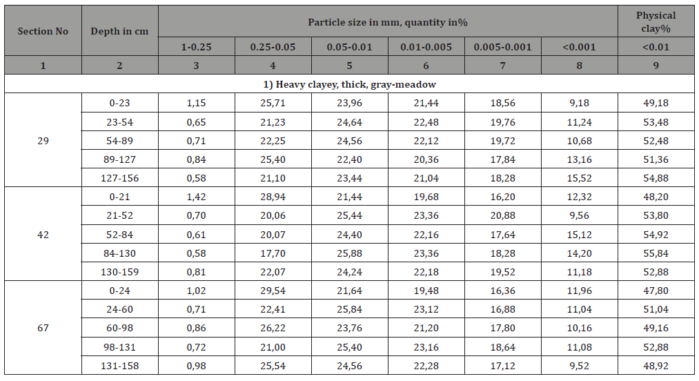
According to the results of laboratory analysis, the granulometric composition of gray-meadow soils is heavily clayey. Thus, the amount of physical clay in these soils is 47.80-49.18% in the upper layers, and the profile length is 47.80-55.84% (Table 2).
Table 2: I) Granulometric composition of gray-meadow soils (in absolute dry soil, in %).
The hygroscopic humidity of the main components varies between 4.1-5.3% throughout the profile.
Total humus is 2.07-2.23% in the upper layers, and the profile length is 1.09-2.23%. According to the total humus, the total nitrogen content is 0.10-0.17%. The amount of carbonate is 10.69- 13.68% throughout the profile. The pH in the water suspension is 8.20-8.33 units, which indicates that these soils are alkaline (Table 3).
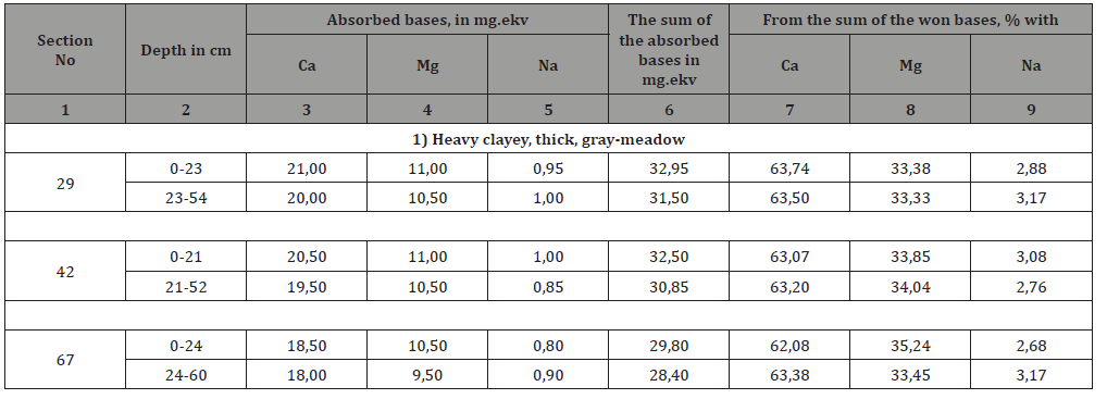
The total amount of absorbed bases in gray-meadow soils is 28.40-32.95 mg. As a percentage, the Ca base is 62.08-63.74%, the Mg cation is 33.33-35.24%, and the Na cation is 2.68-3.17% (Table 4).
Table 3: I) The main components of gray-meadow soils (absolute dry soil, in %).
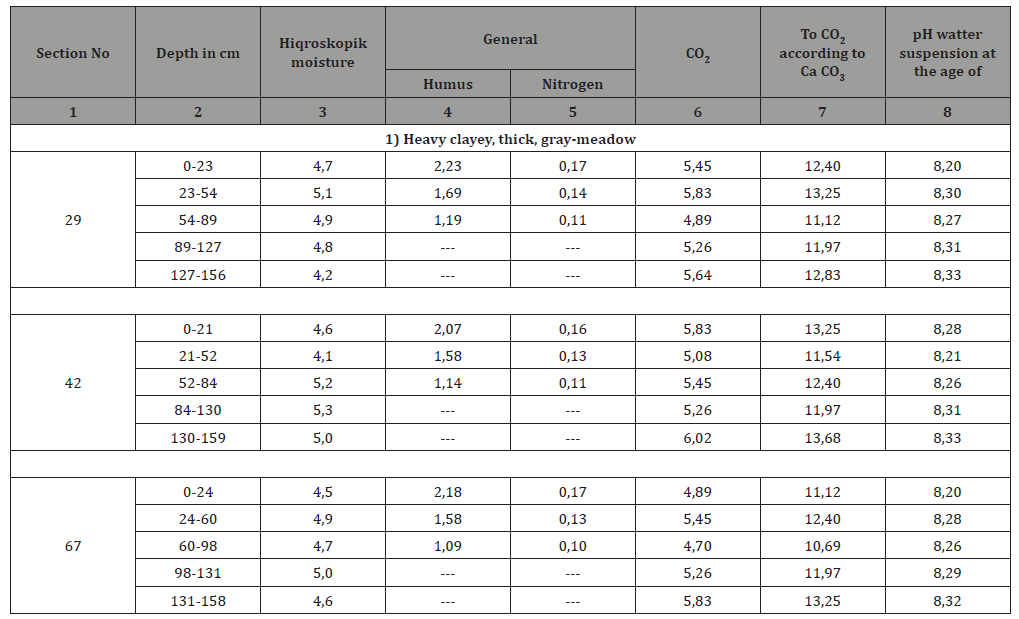
Table 4: I) Number of absorbed bases in gray-meadow soils (absolute dry soil, in %).
II. Light gray-meadow soils
Light gray-meadow soils cover 1041.28 ha or 47.75% of the total area, spreading to the north and south of the study area.
These soils are divided into the following types according to their granulometric composition and thickness of the soil layer.
• Light clay, thick, light gray-meadow
• Heavy clayey, thick, light gray-meadow
To get acquainted with the characteristic morphological features of these soils, we give a description of section 55 excavated in the area.
• 0-22 cm light gray, topavari, light clay, solid, rootand roots, boiling, dry, clear transition
• 22-55 cm light gray, topavari, light clayey, less solid, root residue, boil, dry u, the transition is gradual
• 55-88 cm grayish, small clumpy, lightly clayey, less solid, vertical cracks, boils, less moisture, gradual transition
• 88-122 cm grayish, small topavari, light clay, soft, rust stains, boils, less moisture, gradual transition
• 122-155 cm straw, not selected, light clay, soft, carbonate spots, boils, less moisture.
It is clear from the morphological description of the section that the color of these soils is light gray in the upper layer, light gray and gray in the middle layers, and straw in the lower layer. The structure is not selected on the top layer, topavari and small topavari on the middle layer, and on the bottom layer. The granulometric composition is light clay throughout the profile. The density is hard on the top layer and less hard and soft on the bottom layers. Roots and rhizomes, root residue, vertical cracks, rust and carbonate stains are found along the profile from new derivatives and alloys. These soils are boiled under the influence of 10% hydrochloric acid (HCl). Humidity is dry in the upper layers and less moist in the lower layers. Transitions to genetic layers are clear and gradual throughout the profile.
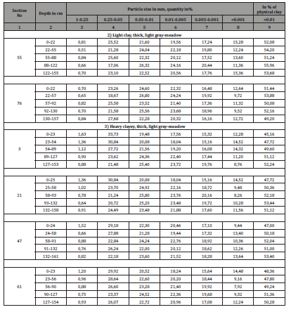
According to the results of laboratory analysis, the granulometric composition of light gray-meadow soils is light clayey and heavy clayey. Thus, the amount of physical clay in these soils is 45.16- 52.08% in the upper layers, and the profile length is 45.16-55.96% (Table 5).
Table 5: I) II) Granulometric composition of light gray-meadow soils (absolute dry soil, in %).
The hygroscopic humidity of the main components varies between 4.3-5.3% throughout the profile. Total humus is 1.74- 1.96% in the upper layers, and the profile length is 0.76-1.96%. According to the total humus, the amount of total nitrogen is 0.08- 0.16%. The amount of carbonate is 10.26-14.11% throughout the profile. The pH in the water suspension is 8.19-8.34 units, which indicates that these soils are alkaline (Table 6).
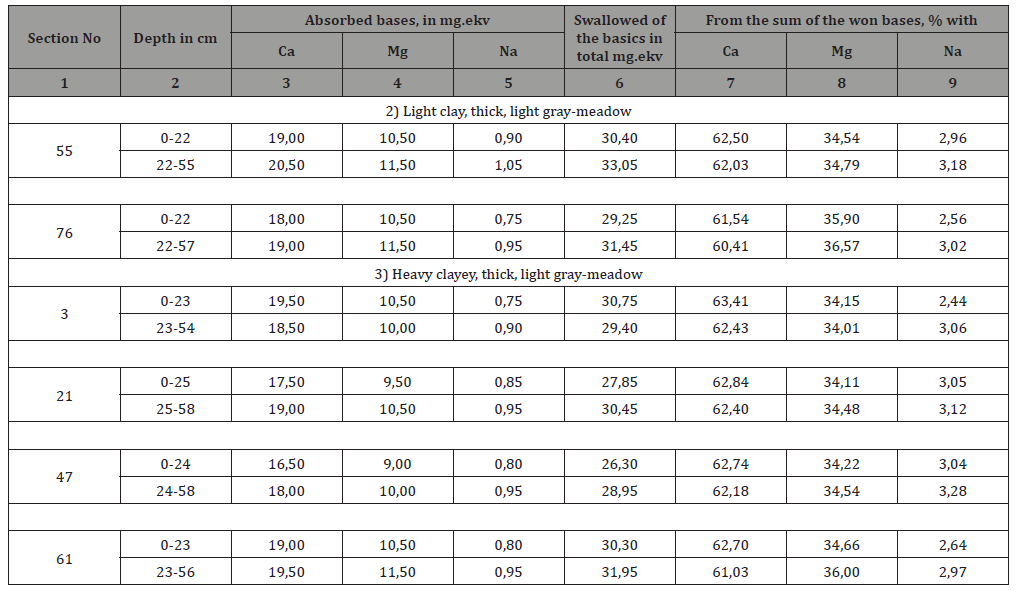
The total amount of absorbed bases in light gray-meadow soils is 26.30-33.05 mg. The percentage of Ca cations is 60.41-63.41%, the Mg cation is 34.01-36.57%, and the Na cation is 2.44-3.28% (Table 7).
Table 6: II) The main components of light gray-meadow soils (in absolute dry soil, in %).
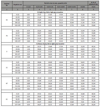
Table 7: II) Number of absorbed bases in light gray-meadow soils (absolute dry soil, in %).
Acknowledgement
None.
Conflict of Interest
No conflict of interest.
References
- BH Aliyev, IN Aliyev (2004) Some problems of agriculture in Azerbaijan and their solutions. Ziya-Nurlan.
- BH Aliyev, SM Nurullayev (2006) Measures to combat irrigation erosion. MBM.
- Garib Mammadov, Mahmud Khalilov (2004) Ecology and the environment. Science, pp. 210-216.
- (1998) Study of the problem of efficient use of eroded lands and irrigation of agricultural crops in Azerbaijan.
- Mammadov TS (2010) The trees and bushes of Apsheron. Science and education. 216 p.
- Mammadov TS, Isgandar EO, Talibov TH (2016) The rare trees and bushes of Azerbaijan. Science, 116 p.
- Eugene A Vaganov, Spirov VV (1978) The study of meteorological conditions of the season of the tree using reflectograms of tree rings. Analysis of the dynamics of biological objects, M, Science, pp. 103-115.
- Shiyatov SG (2000) Methods of dendrochonology. (Krasnoyarsk), 80p.
- Campelo F, Garcia Gonzalez I, Nabais C, Detrender AR (2012) Graphical User İnterface to process and visualize tree-ring data using, Dendrochronologia 30, pp. 57-60.
- Schweingruber FH (1996) Tree Rings and evaronment Dendrochronology. D Reidel Bern, (Stutgard, Wenna) Paul Haupt, pp 609.
- Rinn F (1996) TSAP. Version 3.0 Reference manual computer program for time series analysis and presentation copyright Frank Rin Distrubution, (Heidelberg, Germany), 246 p.
-
ZH Aliyev. Post Freudian Moses and Monotheism. Study of the Agro-Industrial Properties of the Soil Cover of the Agjabadi Region in the Example of the Garadolag Administrative Village. World J Agri & Soil Sci. 5(5): 2020. WJASS.MS.ID.000626.
-
Soil formation, Soil cover, Gray-meadow, Light gray-meadow, Heavy clayey, Light clayey salinity, Salinity, Erosion
-

This work is licensed under a Creative Commons Attribution-NonCommercial 4.0 International License.


