 Mini Review
Underwater Geoarchaeological Survey of Lake Pamvotis, Greece
Geraga Maria1, Papatheodorou George1*, Christodoulou Dimitris1, Fakiris Elias1, Iatrou Margarita1, Kordella Satvroula1, Prevenios Michael1, Deregas Nikos1, Vafiadou Konstadina2
1Department of Anthropology, 1Laboratory of Marine Geology and Physical Oceanography, Department of Geology, University of Patras, Greece
2Ephorate of Underwater Antiquities, Ministry of Culture and Sports, Greece
Papatheodorou George, Laboratory of Marine Geology and Physical Oceanography, Department of Geology, University of Patras, 26504 Greece.
Received Date: August 03, 2020; Published Date: August 27, 2020
Abstract
The Laboratory of Marine Geology and Physical Oceanography, Department of Geology, University of Patras, Greece conducted a systematic geophysical survey in the lake Pamvotis located at the north-western Greece. The purpose of the Pamvotis project was twofold: to investigate the geomorphological and environmental status of the lake and to detect possible archaeological or cultural heritage sites in the lake. The Ephorate of Underwater Antiquities supervised the later part of the project. To achieve these aims, a systematic remote sensing survey conducting side-scan sonar, subbottom profiler and Remote Operated Vehicle (ROV) was carried out.
Remote sensing techniques have been proved as a powerful tool in underwater archaeology for the detection of historical and ancient shipwrecks Quin et al. [1], Papatheodorou et al. [2], Ferentinos et al. [3] and submerged settlements and landscapes Chalari et al. [4], Papatheodorou et al. [5].
Keywords: Underwater archaeology, lake, side scan sonar, remote sensing techniques
Study area-Historical Background
Lake Pamvotis is effectively a ‘closed’ hydrological system and forms the base-level of a karstic aquifer. It is the remaining of a large ancient lake located in the area. Today the extent of the lake is around 19 square meters, with a maximum depth of approximately 7-8 meters and is located 470 meters above sea level. An island, called “the Island” by the locals is situated northeast in the lake.
The lake Pamvotis with the island have always played a vital part for Ioannina city and are connected with the history of Ioannina. The exact foundation date of the city remains still uncertain. The first time Ioannina city has been mentioned in the records of the synod of Constantinople in 879 AD. Since then, Ioannina was always a prospected city in Greek history. In the middle of the 14th century AD Albanians attacked northwest Greece including the area of Ioannina. One of these attacks took place through the lake Pamvotis. The chronicles highlight that during the night of the 26th February 1379 AD a group of 200 Albanians disembarked from the island of the lake (or the village Perama) to the northwest shore of the lake, resulting in an occupation of the governor’s castle. A further group of Albanians and Bulgarians, who had already disembarked on the island, attacked Ioannina city mainly using monoxyls (logboats). The next important period of Ioannina took place during the governance of Ottoman Ali Pasha. During the rule of Ali Pasha trade, craft and local trade unions continued to develop.
Remote-Sensing Survey
The remote-sensing survey was organized into two phases. First, a survey of the lake-floor was carried out using side-scan sonar and a subbottom profiler for five (5) days. During the first phase all the lake bottom was systematically surveyed and potential targets for further investigation were located. The second phase consisted of visual inspection of the predetermined sites and lasted three (3) days. During this phase the ROV hovered over these locations and the targets were identified on the video camera.
The survey utilized:
(i) An EG&G 272 TD side scan sonar tow fish of a dual frequency (100 kHz and 500 kHz) in association with a 4200 Topside processor Edgetech, digital corrected image recorder,
(ii) A 3.5 kHz subbottom profiling system with a Geopulse transmitter and a 4-array transducer (type O.R.E. 132B) in association with a Triton Elics digital recorder and
(iii) A Hemisphere V100 Global Positioning System (GPS) with an accuracy less than 2m, for the positional data. The navigation of the vehicle was managed by the TritonMap (Triton Imaging Inc) software.
The speed of the vehicle was always 3knots. The operated frequency of the towfish was 100 kHz, since this frequency provides a wide spectrum of acoustic facies regarding the variety of lake floor texture. The range of each side scan sonar lane was 100m for each side and the lane spacing was 150m providing a 50% range overlap. The operated pulse duration of the subbottom profiler was 1ms and the pulse rate was 10 s-1.
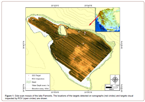
A total area of 17.5 km2 was insonified by tracklines of 70km total length (Figure 1). “SB-Interpreter”, “Isis” and “DelphMap” softwares (Triton Imaging Inc) were used for the processing and the interpretation of the seismic profiles and the side scan sonar records (sonographs).
Geological-geomorphological setting
The 3.5 kHz seismic profiles of the study area, present an upper almost transparent unit overlying a horizon of high acoustic reflectivity and low relief (Figure 2). The surface unit was interpreted as a layer of muddy loose sediments up to 4m thick. No acoustic echoes relative with barren targets were detected (Figure 2). Only acoustic hyperbolas lying on the lake bottom were detected and always these were in agreement with side scan sonar data.
The lake bottom is covered by very fine-grained sediments as indicated by the low reflectivity (dark tone) on the side scan sonar mosaic (Figure 1). Area of high reflectivity (light tone) at the central part of the lake probably represents gas-charged black organic mud (Figure 1).


Targets of Interest
In addition, a total number of 24 sites, scattered all over the bottom of the lake, were detected on the sonographs which presented locally strong backscatter often accompanied with well formed acoustic shadows. These acoustic features often incorporated geometrical shapes of various dimensions. The signal signature of them was interpreted as man-made objects.
During the second phase of the survey ten out of twenty-four were finally examined with the ROV. The reduced amount of sample targets was caused by similar characteristics of the examined targets, which allowed drawing conclusions about the remaining ones. It should be noted that the poor visibility of the water column introduced difficulties in the visual inspection of the targets. As a result close approach of the ROV to the targets were required and more extensive ROV operations.
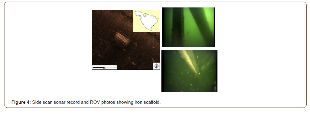
The targets were: geological formations (small sized craters), reed (Phragmites communis; or reed debris) (Figure 3), iron scaffolds (Figure 4) and garbage. No remains of archaeological interest could be detected.


Conclusion
Although, none of the targets proved to be of archaeological interest, from an archaeological point of view the project has its relevance. It has been the first time in Greece that a lake was examined archaeologically following systematic remote sensing techniques which have proven to be functional and time efficient. The project also enables deducting critical success factors for this type of survey like the gained experience with low visibility when using ROV. The archaeological focus of the Pamvotis project allowed to disprove theories and speculations about shipwrecks and other archaeological remains.
References
- Quinn R, Cooper J A G, Williams B (2000) Marine geophysical investigation of Northern Ireland of the inshore coastal waters. International Journal of Nautical Archaeology 29(2): 294-298.
- Papatheodorou G, Geraga M, Ferentinos G (2005) The Navarino Naval Battle site, Greece – an integrated remote sensing survey and a rational management approach. International Journal of Nautical Archaeology 34(1): 95-109.
- Ferentinos G, Fakiris E, Christodoulou D, Geraga M, Dimas X, et al. (2020) Optimal sidescan sonar and subbottom profiler surveying of ancient wrecks: The ‘Fiskardo’ wreck, Kefallinia Island, Ionian Sea. Journal of Archaeological Science 113: 105032.
- Chalari A, G Papatheodorou, M Geraga, D Christodoulou, G Ferentinos (2009) A marine geophysical survey illustrates Alexandria’s Hellenistic past. Zeitschrift fur Geomorphologie 53: 191-212.
- Papatheodorou G, Geraga, M, Christodoulou, D, Iatrou M, Fakiris E, et al. (2014) A marine geoarchaeological survey, Cape Sounion, Greece: Preliminary results. Mediterranean Archaeology and Archaeometry 14(1): 357-371.
-
Geraga Maria, Papatheodorou George, Christodoulou Dimitris. Underwater Geoarchaeological Survey of Lake Pamvotis, Greece. Open Access J Arch & Anthropol. 2(4): 2020. OAJAA.MS.ID.000543.
-
Psychiatric Hospitals, Psychologists, Modus Operandi
-

This work is licensed under a Creative Commons Attribution-NonCommercial 4.0 International License.


