 Research Article
Ancient Iron-Smelting Site “East Hungai” on Olkhon Island (Lake Baikal, Russia): Rock-Magnetic Approach to Archaeological Problems
Galina G. Matasova1,2*, Alexey Yu. Kazansky2,3, Nikolay O. Kozhevnikov1 and Mikhail S. Kustov4
1Trofimuk Institute of Petroleum Geology and Geophysics of Siberian Branch of Russian Academy of Sciences, Russia
2Geological Institute of Russian Academy of Science, Russia
3Lomonosov Moscow State University, Russia
4Center for the Preservation of the Historical and Cultural Heritage of the Irkutsk Region, Archaeological department, Russia
Galina Gelievna Matasova, Trofimuk Institute of Petroleum Geology and Geophysics of Siberian Branch of Russian Academy of Sciences, Academic Koptug ave. 3, Novosibirsk, Russia.
Received Date: April 15, 2020; Published Date: April 24, 2020
Abstract
Rock-magnetic techniques were used to examine topsoil layer over the “East Hungai” archaeological site on Olkhon Island (Lake Baikal, Siberia) in an effort to determine the possible sources of magnetic anomalies associated with iron smelting activity at about the BC/AD boundary. Measurements of surface and subsurface magnetic susceptibility and laboratory measurements of hysteretic parameters have shown a magnetic heterogenity of strata resulted from the interaction of two factors: the initial differentiation of the bedrock source material and the high intensity of the sedimentary process that contributed to significant desintegration of bedrock and to easy transporting of the disintegrated products. Because bedrock on the east and west sides of the valley are different, the distribution of magnetic susceptibility over the excavation area is rather complex. Nevertheless, susceptibility anomalies corresponding to ore preparation and ore storage zones could be recognized. Most likely East Hungai site was used during prospecting works and trial iron smelting in promising places, which testifies the remarkable activity of ancient metallurgists on the western shore of Lake Baikal
Keywords: Rock-magnetic study, topsoil, magnetic susceptibility, ancient iron smelting, Olkhon Island, Lake Baikal
Introduction
In the recent decades, magnetometry became increasingly popular in the studies of archaeological sites (see e.g. [1, 2]). However, for its successful application it is necessary to have a priori information about the magnetic properties of both artifacts and the geological environment in which artifacts are located. Because, usually, contrasts in the magnetic characteristics of various objects vary in wide ranges, magnetic anomalies will also have different amplitudes and the interpretation of anomalies may be ambiguous [3-6]. In this case, a rock -magnetic study of archaeological sites provides information that is unavailable through more traditional geophysical techniques. It can answer not only archaeological questions about location of magnetic artifacts but also those regarding depositional and post depositional processes. Although rock-magnetic method has been used at some archaeological sites [5- 8], its potential as a new archaeological tool is still underestimated. Due to human industrial impact, magnetic properties of topsoil and/ or sediment may undergo specific changes [7]. The most dramatic changes are usually observed when studying ancient metallurgical sites [9-10]. Due to high temperatures of bloomery processes, the magnetic susceptibility of upper soil layers increases due to the neoformation of magnetic minerals (mainly magnetite) as a result of the baking of soil organic matter. Such changes allow revealing and mapping areas which in ancient times were exposed to high temperatures during iron smelting: slag heaps, baked zones, and zones of preparation of raw materials and of charcoal production. Therefore, the rock-magnetic study of archaeometallurgical sites is promising direction in archaeogeophysics.
In this paper, we describe and discuss rock-magnetic study of recently opened archeological site East Hungai on the Olkhon Island of Baikal Lake (Siberia). The site is represented by remains of bloomery, slag fragments and pieces of ceramics. The study was targeted at the following items:
i. to estimate the ‘background’ (typical for the area) magnetic susceptibility values;
ii. to determine whether there are magnetic susceptibility anomalies on the study site, and if they are, to find their possible sources; and
iii. to reveal possible regularities in the distribution of the magnetic material and a possible mechanism of its transport over the study area,
iv. to propose the ways of using rock-magnetic data to solve archaeological problems at the East Hungai site.
Materials and Methods
Site description and sampling
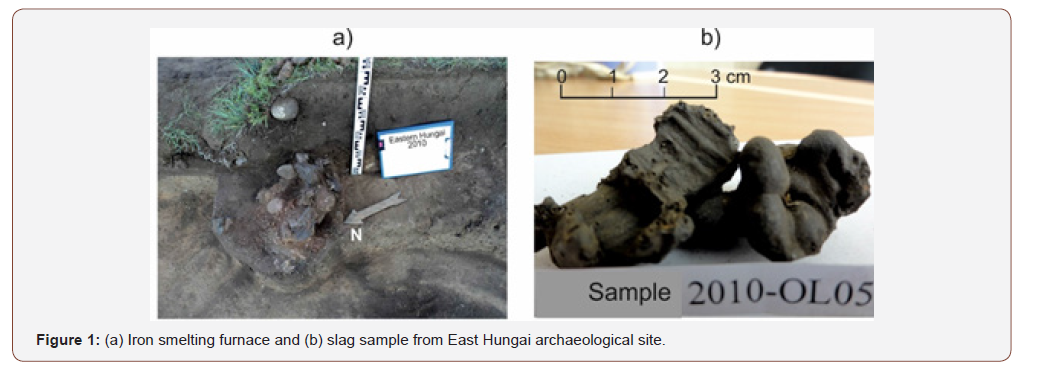
Archaeological site “East Hungai” is located on the eastern side of Hungay bay on the north-western bank of Olkhon Island (N 53º05’45’, E 107º13’30’). The site is located in a dry valley formed by gentle slopes of two low (elevation above Baikal Lake is less than 60m) hills. The site includes remains of an iron making furnace which is exposed in escarp of the first terrace of Baikal Lake and covers the adjacent territory about 150 square meters eastward from the furnace where a few slag fragments were found (Figure 1). The age of the iron-smelting industry at the East Hungai site is approximately defined from the end of the first millennium B.C. to the first half of the first millennium A.D by the analogy with metallurgical sites of Kurma and Barun-Hal [11-12]. These sites are located on the opposite shore of Lake Baikal in front of the East Hungai (Figure 1).
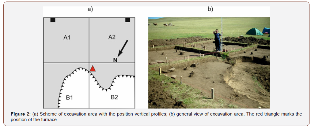
The excavation area of 10 × 10 meters was laid in the central part of the East Hungai archaeological site and is divided into four 5×5 meters squares, designated A1, A2, B1 and B2 (Figure 2). The boundary between A1, B1 and A2, B2 squares nearly coincides with the valley line. In addition, two vertical profiles were excavated in southern parts of squares A1 and A2, to a depth of 70 cm. Field measurements of magnetic susceptibility accompanied by rockmagnetic sampling for further laboratory studies were performed every 5 cm down the walls of the profiles (Figure 3).
In-field surface measurements of magnetic susceptibility were carried out over all the area of the archaeological site excluding the slope beneath the scarp of the terrace in squares B1 and B2. Measurements were performed at three different hypsometric levels:
a. on the surface;
b. at a depth of 30 cm;
c. at a depth of 50 cm.
The measurements had different goals and, accordingly, were performed with different scales: on the surface - on a 1m×1m grid; at a depth of 30 cm - on a grid of 20cm×20cm; at a depth of 50 cm - on a grid of 50cm×50cm. Surface measurements were aimed at revealing the “background” magnetic susceptibility values for the given area and soil type. These values are needed for deciding whether or not there are magnetic susceptibility anomalies at the studied area. At the same time, recent sources of anomalies (metal objects left by tourists) were ignored, and the anomalies created such sources were not taken into account. Measurements of magnetic susceptibility at a depth of 30 cm were carried out in order to detect traces of ancient human activity by searching for magnetic susceptibility anomalies and recognizing their nature. In places where archaeological objects (slags, fragments of ceramics, bonfires) were found, the magnetic susceptibility was measured twice: before and after removing of anthropogenic objects, i.e. at first near the artifacts and than directly on the surface of the exposed layer free of artifacts. Measurements at a depth of 50 cm were performed to estimate variations in the subsoil layer magnetic susceptibility.
Magnetic measurements
Field measurements of magnetic susceptibility were carried out using KT-5 susceptibility meter. This instrument gives volumetric magnetic susceptibility of approximately 5×5×5 cm volume of the near-surface substance.
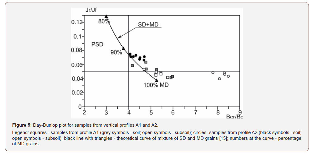
Laboratory measurements of mass-normalized magnetic susceptibility (χ) and its frequency dependence (FD %) were carried out using Bartington MS2 meter with the dual frequency probe MS2B. Hysteretic loops were recorded using a J_meter coercive spectrometer manufactured by KFPU (Kazan, Russia) [13]. From the measurement results the following magnetic parameters were calculated: remanent saturation magnetization (Jr); saturation ferromagnetic magnetization (Jf) free of paramagnetic input; paramagnetic magnetization (Jp) in the field of 700 mT; coercive force Bc and remanent coercive force (Bcr). Domain state of ferromagnetic grains was determined using Day/Dunlop biplot of Bcr/Bc and Jr/Jf ratios [14-15]. All measurements were made in accordance with generally accepted methods [7].
Results
Vertical profiles
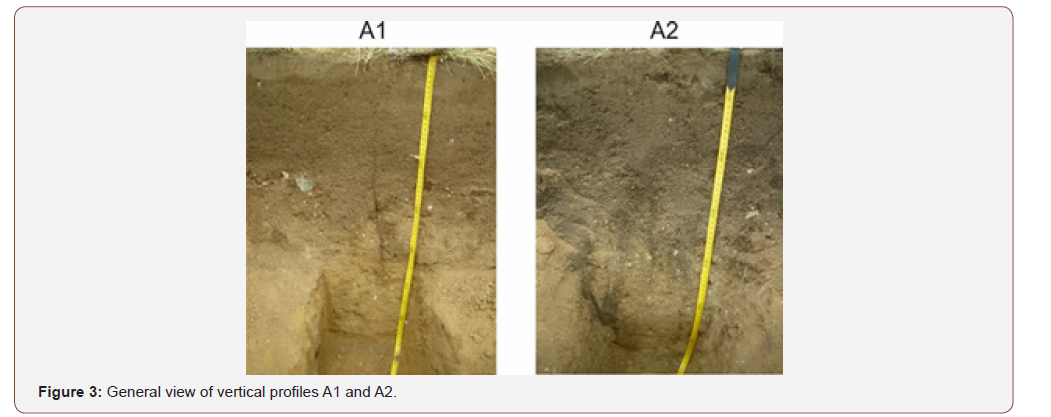
Both profiles have a similar structure which includes steppe soil: organic (O) and humic (A) horizons, illuvial horizon (B) and parent rock (C). They are represented by sand and sandy loam of slope-wash genesis (talus) with debris of bedrock of different size and composition (Figure 3).
Despite the distance between profiles does not exceed 8 meters, the magnetic characteristics of soils and underlying sediments in squares A1 and A2 differ significantly (Figure 4). First of all, this concerns rock-magnetic parameters characterizing mainly the concentration of ferromagnetic material - magnetic susceptibility χ, magnetizations Jr and Jf. All of these parameters are, on average, 3-4 times higher in the profile of square A1 than in the profile of square A2. The dependence of these parameters versus depth also varies significantly (Figure 4).
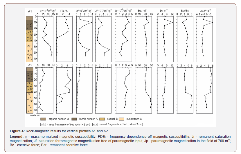
First, with a few exceptions (the third point on profile A1), the underlying strata in square A1 is much more magnetic than soil horizons, while in the square A2 - the situation is opposite. Secondly, the correlation between χ and Jr is significantly higher in the A1 square (r = 0.87) than in the A2 square (r = 0.65). Comparison of other magnetic characteristics reveals a similarity between the two profiles. The values and trends in the change of the magnetic susceptibility frequency dependence (FD factor) are approximately similar, but their correlations with the low-frequency χ in two squares are opposite: in both profiles, the correlation coefficients have close values but are opposite in sign (rA1 = -0.57; rA2 = 0.56). Variations in FD along profiles indicate the most intense process of formation (accumulation) of fine-grained magnetic minerals, the so-called superparamagnetic (SPM) grains occurs at a depth of 30- 40 cm, i.e. in the lower part of the soil profile and on the interface with the underlying layer.
The behavior of paramagnetic magnetization Jp in both profiles is approximately the same, which indicates the similar paramagnetic content and distribution of Jp versus depth: the highest concentration of paramagnetic minerals is observed in the upper (to a depth of 15 cm) horizons; with depth, it decreases gradually in the lower soil horizons and in the underlying layer (Figure 4).
The coercive characteristics (Bcr, Bc) also exhibit similar behavior and values on both profiles, but only in soil horizons (Figure 4). At the moment, there is no explanation for the behavior of these characteristics at point 3 of profile A1, therefore we consider it as an experimental error and exclude it from consideration. Bc and Bcr values throughout entire A1 profile practically do not change, their behavior is synchronous, with a correlation coefficient r = 0.75, while in the parent rock of A2 profile Bcr and Bc change in opposite manner with a correlation coefficient r = -0.78.
The biplot of Bcr/Bc and Jr/Jf ratios characterizes the predominance of multi-domain (MD) particles in the magnetic fraction in all sediments (Figure 5). In A1 profile, the difference between the soil horizon and parent rock is insignificant and the points on the Day plot occupy a compact area which corresponds to 100% content of MD grains (Figure 5). On the contrary, on the A2 profile soil samples show 90% MD content while parent rock samples are located far from the referent curve [15] due to enhanced Bcr/ Bc ratio values (Figure 5). It may be caused both by very coarse magnetic grains and mixture of MD and SPM grains.
Surface magnetic measurements
The results of magnetic susceptibility measurement for all three hypsometric levels (present day surface, depth 30 cm and depth 50 cm) are presented in Figure 6.
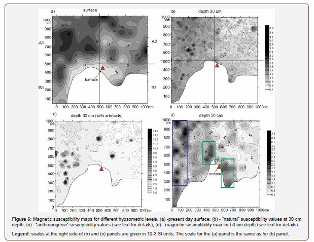
The distribution of magnetic susceptibility over the excavation area completely fits the regularities revealed from the study of vertical soil profiles in Figure 3, where the average magnetic susceptibility, for example, of the underlying layer is 3-4 times higher in the square A1 than in the square A2. It is clearly seen that the eastern part of the archaeological site (squares A1, B1) exhibits enhanced values of magnetic susceptibility at all three levels. The area of enhanced magnetic susceptibility on the presentday surface in square A2 with the center at coordinates (X)1050, (Y) 650 is situated in area occupied formerly by tourist camp and is caused by the remains of a recent fireplace (Figure 6 a). This anomaly disappears at a depth of 30 cm and, accordingly, does not relate to natural phenomena. In the remainder of excavation area the distribution of magnetic susceptibility is probably determined by geological processes.
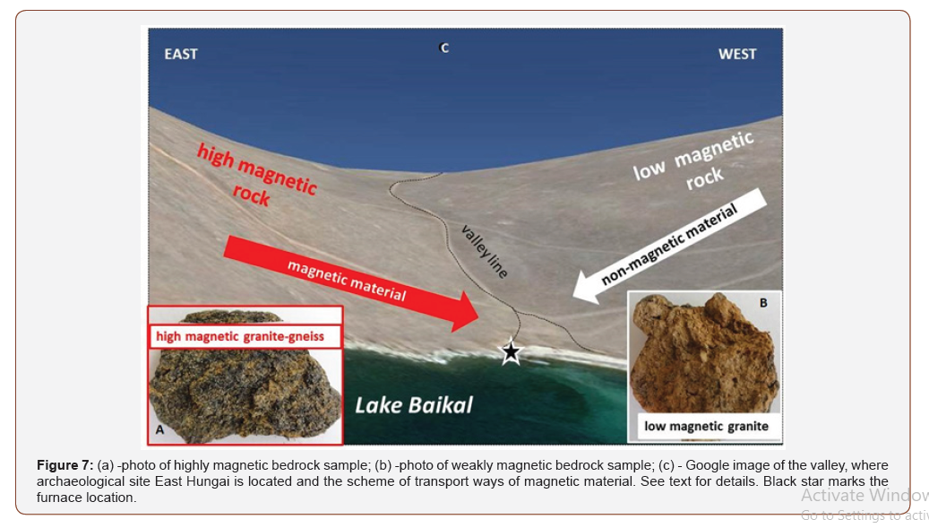
At a depth of 30 cm, the “anthropogenic” (with artifacts) and “natural” (after removing artifacts) maps are generally similar but different in details (Figures 6b & c), while both are quite different from the surface map. First of all, the difference lies in the values of magnetic susceptibility. Its highest values on the “anthropogenic” map are due to slags - highly magnetic products of ancient metallurgy. Most of the slags are found in squares A1 and B1 (Fig. 6c). Besides slags, some bedrock fragments are also exhibit enhanced values of magnetic susceptibility. Such fragments are represented by yellow-gray to dark gray and black granite-gneiss (Figure 7a), biotite-amphibolite gneiss and schistized amphibolite. The rocks were identified during the field campaign by Prof. V.I. Levitsky (Vinogradov Institute of Geochemistry Siberian Branch Russian Academy of Sciences, Irkutsk, Russia).
The next difference between the “natural” and “anthropogenic” maps is one in the anomalies source, which causes the mismatch of the anomalous points with a few exceptions. On the “natural” map, anomaly points indicate mainly “contamination” of the soil by very small fragments of strongly magnetic rocks, probably the product of crushing of large ore pieces (Figure 6b). On the “anthropogenic map”, anomaly points are due to slags, locations of the slags fragments are sporadic and in no way associated with ore fragments (Figure 6c).
The distribution of magnetic susceptibility at a depth of 50 cm differs sufficiently from that in the overlying horizons (Figure 6d), although the difference in the background values for western and eastern parts of the excavation area remains. Instead of the alternation of small-size susceptibility anomalies with different amplitudes (Figure 6b), large-size anomalies have amplitudes of 2.5-3.5×10⁻³ SI. They are located in the eastern part of the excavation area (blue rectangles in Figure 6d) and near the furnace (green rectangles). Significant anomalies from artifacts on this surface were not observed.
Discussion
Values and behavior of rock-magnetic parameters of soils and underlying parent sediments in the squares A1 and A2 are substantially different; these differences are preserved for depth up to 70 cm. The above differences are follows:
I. The concentration of magnetic minerals in the soil and, especially, in the underlying parent layer in square A1 is significantly higher than in square A2;
II. The sizes of magnetic grains as estimated by their domain state are much coarser in the underlying layer of square A2 than in square A1; magnetic grains in soil horizons of the square A2 are finer than in the similar horizons of the square A1.
Given the proximity of the excavation profiles, this fact, as such, requires an explanation, which will help to clarify whether this anomalous phenomenon is natural or artificial, caused by the ancient iron production activity.
The nature of the difference in magnetic susceptibility.
The East Hungai archaeological site is located in the valley, the western and eastern slopes of which exhibit significantly different bedrock magnetic properties The expositions on the east slope are represented by granite-gneiss (Figue 7a) with high (up to 10-1 -10-2 SI) values of magnetic susceptibility, while the bedrocks of west slope are composed by granites and meta-sedimentary rocks (Figure 7b) with magnetic susceptibilities less than 10-5 SI. We suggest that weathering products of the bedrock from both sides of the valley were transporting along the slopes down to Baikal Lake by temporary flows and mixing with the upper soil layer. That resulted in a fairly uniform increase in the magnetic susceptibility of the soil cover on the eastern slope and relative decrease of susceptibility on the western slope (Figure 7). This assumption is strengthened by measurements of the topsoil magnetic susceptibility outside the excavation site: the surface layer on the eastern slope is characterized by enhanced susceptibility values with an average close to that at the archaeological site in squares A1 and B1. The topsoil from the western slope demonstrates low “background” values of magnetic susceptibility. Since the center line of the excavation area, dividing it into squares A1, B1, on the one hand, and A2, B2, on the other, was laid along the valley line, the enhanced magnetic susceptibility of the surface soil layer on the eastern side and lower values on the western side are the result of natural denudation from the surrounding hills (Figure 7).
However, the valley is dry (annual precipitation is here less than 200 mm/year), the elevation of surrounding hills is less than 60 m above the level of Lake Baikal and their slopes are very gentle. It is unlikely that large (up to 10 cm in size) fragments of bedrock could be transported by slope-wash process in such landscape environment. That is why we assume it was due to a process with energy greater than that of the slope wash. This process resulted in eroding highly magnetic bedrock and depositing thick cover of sandy loam and loam with bedrock fragments of different sizes. Such an event could be the impact of the megaflood caused by the tsunami from the co-seismic landsliding that occurred on Lake Baikal 11.8-13.4 thousand years ago [16]. Thus, we conclude that the differentiation in magnetic properties of sediments on the East Hungai site resulted from the interaction of two factors, namely of the initial differentiation of the bedrock material and of the high-energy sedimentary process, which contributed to intensive desintegration of bedrock and to easy transport of the disintegrated products.
The possible iron ore source
The magnetic susceptibility values on the surface layer of the eastern slope are comparable with those in the topsoil the Kurma iron-smelting center on the opposite bank of Baikal Lake [6]; therefore, the concentration of magnetic material in these two iron-smelting sites is approximately the same. Taking into account the neighboring location of those two sites (14 kilometers in a straight line across Lake Baikal) that provide free migration of the population between sites during the winter over the ice, we can assume that the iron technology in the center of Kurma and in the East Hungai site was the same. This means that the ore source for iron production for the both sites was also the same - the loose products of weathering of strong magnetic bedrock slope-washed down the slope (talus).
The nature of susceptibility anomalies at 50 cm depth
Since the fundamental differences in the values of magnetic susceptibility in the eastern (squares A1 and B1) and western (squares A2 and B2) parts of the excavation area are stored at all the three hypsometric levels (0 cm, 30 cm, 50 cm), they have not anthropogenic but a natural cause, which is already discussed above. From the archaeological point of view, the most interesting are the anomalies that appeared only at the depth of 50 cm. Since the furnace in the study area is located at a depth of 40-60 cm from the day surface (Fig. 1), these anomalies can be associated precisely with the process of iron production. It is known that in the immediate vicinity of metallurgical furnaces, under the influence of high temperatures, magnetic the susceptibility of the topsoil increases due to the neoformation of magnetic minerals (mainly magnetite) as a result of burning soil organic matter [9, 10]. Most likely the anomalies inside the green rectangles on Fig. 6d are connected with furnace operation: the anomaly in the eastern rectangle is associated with ore storage before charging into the furnace, while west anomaly with lower intensity may be considered as smithing zone. The most eastern linearly elongated group of anomalies (inside the blue rectangle in Figure 6d) located at some distance from the furnace most likely corresponds to a large zone of preparation of the material for the melting process. At least two such zones are known in ancient iron smelting centers: zone of charcoal production and zone of raw material preparation (washing, roasting and crushing) [10]. Since no charcoal remains were found in this area, and fragments of presumed ore found quite often, we suggest that this area is a raw material preparation zone.
The scale of iron-smelting activity in East Hungai site
The furnace in the East Hungai is the only one in this part of Baikal shore; no other furnaces were found in the vicinity of Hungai Bay. The amount of slag found during excavation is rather small, up to 1 kg in weight, as well as amount of clay pottery fragments (few pieces only). When compared to slag volumes (up to hundreds of kilograms) in the neighboring metallurgical sites of Kurma and Barun-Hal, where iron production has been operating for several centuries [11,12], the small slag amount at East Hungai indicates that only single, probably, trial iron smelting was run here. Indirectly, this assumption also strengthened by very small amount of the pottery finds of ceramics. Apparently, the quality and/or small amount of iron ore in the vicinity of the site were not favorable for a long-lived smelting production here. Thus, as evidenced by the furnace, the ancient metallurgists were exploring and looking for convenient and promising places for organization of a large-scale iron production.
Conclusion
The study of the rock-magnetic properties of the geological environment at the archaeological site “East Hungai” has shown that the magnetic anomalies associated with the ancient metallurgical activity are complicated by the natural geological setting. High concentration of magnetic minerals in the weathering products increases the “background” magnetic susceptibilities of all soil horizons and underlying sediments. The ranges of magnetic susceptibility of the horizons overlap the magnetic susceptibility range of most archaeological finds (except slags), and those objects did not appear on the susceptibility maps at all three hypsometric levels.
The eastern and western parts of the excavated area exhibit different rock-magnetic properties (in terms of concentration and sizes of magnetic grains) due to the interaction of two geological factors, namely, of the initial differentiation of the source (bedrock) material and of the high-energy sedimentary process. These processes contributed to intensive desintegration of bedrock on the east and west sides of the valley and to easy transporting of those disentegrated products. The possible reason of this high-energy sedimentary environment may be co-seismic tsunami in Baikal Lake 11.8-13.4 Kyr ago. Most likely, the disintegrated material from highly magnetic granite-gneiss on the eastern side of the valley served as a raw material for the iron-smelting at the site.
Despite complex magnetic susceptibility distribution on the 50 cm level, it was possible to recognize magnetic susceptibility anomalies presumably associated with the iron production. The group of anomalies in the western part of the excavation area marks the zone of raw material preparation (washing, roasting and crushing), while the near-to-furnace anomalies mark places of ore storage for further charging ore into the furnace and, probably, a smithing work place.
The finding of only a small single furnace and absence of large deposits of high-magnetic iron ore in the nearby area may indicate that ancient metallurgists used prospecting works and trial iron smelting in promising (from their viewpoint) places, which testifies the remarkable activity of ancient metallurgists on the western shore of Lake Baikal.
Acknowledgement
None.
Conflict of Interest
No conflict of interest.
References
- Smekalova T, Voss O, Smekalov S, Myts V, Koltukhov S (2005) Magnetometric investigations of stone constructions within large ancient barrows of Denmark and Crimea, Geoarchaeology 20(5): 461-482.
- Faßbinder JWE, H Stanjek (1993) Occurrence of bacterial magnetite in soils from archaeological sites. Archaeological Poloina 31: 117-128.
- Faßbinder JWE (2016) Magnetometry for Archaeology. In: Encyclopedia of Geoarchaeology, Allan S. Gilbert, et al (Edt.), Encyclopedia of Earth Sciences Series, Springer Netherlands, pp. 495-514.
- Krivonogov SK, Kazansky AK, Chemyakina MA, Matasova GG, Vasilevsky AN (2009) The interpretation of magnetic data by instruments of GIS and modeling the anomalous magnetic field based on the data for the Chicha- 1 archaeological. In: Molodin, V I, Partsinger G, (Eds.), Chicha - gorodishche perekhodnogo ot bronzy k zhelezu vremeni v Barabinskoi lesostepi (Chicha: Archaeological Settlement of the Bronze to Iron Transition Age in the Barabinsk Forest Steppe), Novosibirsk, Russia 3: 9-20.
- Matasova GG, Kazasnky AYu, Kozhevnikov NO, Snpokov SV, Kharinsky AV (2017) Rock-Magnetic Quest for Possible Ore Sources for the Ancient Iron-Smelting Industry in the Olkhon Region (Lake Baikal, Siberia). Archaeometry 59(3): 511-527.
- Matasova GG, Kazansky A Yu, Pozdnyakova OA (2016) The Experience of Using the Rock Magnetic Methods for Assessing the Prospects of Magnetic Exploration in the Territory of Archaeological Monuments of the Barabinsk Forest Steppe. Izvestiya, Physics of the Solid Earth 52(6): 870-884.
- Evans M E, Heller F (2003) Environmental Magnetism, Academic, New York, USA.
- Herries A I R (2009) New approaches for integrating palaeomagnetic and mineral magnetic methods to answer archaeological and geological questions on Stone Age sites, in New directions in archaeological science. A. Fairbairn, S. O’Conner, and B. Marwick (Eds.), Australian National University Press, Canberra, Australia, pp. 235-253.
- Vernon R W, McDonnell J G, Schmidt A (1998) An integrated geophysical and analytical appraisal of early ironworking: three case studies. Historical Metallurgy 32: 67-81.
- Powell A J, McDonnell J G, Batt C M, Vernon, R W (2002) An assessment of the magnetic response of an iron-smelting site. Archaeometry 44: 651-665.
- Kozhevnikov N O, Kharinsky A V, Kozhevnikov O K (2001) An accidental geophysical discovery of an Iron Age archaeological site on the western shore of Lake Baikal. Journal of Applied Geophysics 47: 107-122.
- Kozhevnikov N O, Kharinsky A V, Snopkov, S V (2019) Geophysical prospection and archaeological excavation of ancient iron smelting sites in the Barun‐Khal valley on the western shore of Lake Baikal (Olkhon region, Siberia). Archaeological Prospection 26: 103-119.
- Jasonov P G, Nurgaliev D K, Burov B V, Heller F (1998) A modernized coercivity spectrometer. Geologica Carpathica 49(3): 224-226.
- Day R, Fuller M, Schmidt V A (1977) Hysteresis properties of titanomagnetites: grain-size and compositional dependence. Physics of the Earth and Planetary Interiors 13: 260-267.
- Dunlop D J (2002) Theory and application of the Day plot (Mrs/Ms versus Hcr/Hc). Journal of Geophysical Research: Solid Earth 107: 2046-2067.
- Arzhannikov SG, Ivanov AV, Arzhannikova AV, Demonterova EI, Jansen J D, et al. (2018) Catastrophic events in the Quaternary outflow history of Lake Baikal, Earth-Science Reviews 177: 76-113.
-
Galina G. Matasova, Alexey Yu. Kazansky, Nikolay O. Kozhevnikov, Mikhail S. Kustov. Ancient Iron-Smelting Site “East Hungai” on Olkhon Island (Lake Baikal, Russia): Rock-Magnetic Approach to Archaeological Problems. Open Access J Arch & Anthropol. 2(2): 2020. OAJAA.MS.ID.000534.
-
Magnetometry, Archaeometallurgical, Archaeogeophysics.
-

This work is licensed under a Creative Commons Attribution-NonCommercial 4.0 International License.


