 Research Article
Pedestrianisation Zoning and Air Quality in Hong Kong
Andy Chan* and Kenneth Chow
University of Nottingham Malaysia, Jalan Broga, Selangor Draul Ehsan, Malaysia
Andy Chan, University of Nottingham Malaysia, Jalan Broga, Semenyih 43500, Selangor Draul Ehsan, Malaysia.
Received Date: July 20, 2021; Published Date: August 10, 2021
Abstract
Air quality assessment in the vicinity of the Causeway Bay Pedestrianisation Scheme is conducted. The study analyses the concentration of respiratory suspended particulates, nitrogen oxides and carbon monoxides and shows that reductions for the three pollutants could be achieved at Hennessy Road and Great George Street. However, this would transfer the air pollution to nearby roads due to traffic diversion. The justifications of shifting air pollution from one place to another are that the targeted areas are more prone to pollutant buildup and the shift would maximise the number of benefactors.
The improvement in air quality is compared with field data obtained from the roadside field data. Comparisons show that the improvement recorded at the station is lower than the predicted one. The difference between the projected and recorded improvements is because only part of the scheme has been implemented. The study shows that pedestrianisation does bring improve in air quality in urban areas.
Introduction
In spite of a total area of just over 1,100 km2 (prime flat land less than 10% of this area), Hong Kong is one of the most exuberant examples of modern metropolises. Hong Kong is the world’s 9th largest trading economy and a major international aviation centre. The other side of the story is that Hong Kong is reported to have low environmental standard, air pollution in particular. In a pool of selected cities, Hong Kong ranked fourth, sixth and fourth in terms of high level of concentration for respiratory suspended particulates (RSP, annual average), ozone (hourly average) and nitrogen dioxide (annual average) respectively [1]. Although the government is continuously tightening emission standards through various ordinances, the concentration level for most pollutants is likely to remain at the present level for the immediate future [2].
List most well-developed cities, vehicular traffic is a prevailing problem with busy commercial districts. The problem further aggravates when the popularity of the district increases. For shopping centres, the business community naturally welcomes more visitors patronising the district. However, the development will reach a point when the district is unable to accommodate too many commuters accessing to the district by vehicle. To ease the problem, pedestrianisation is one of the initiatives introduced in late nineties to change the commuters’ habit of travelling.
In 1999, the Transport Department (TD) announced the commencement of pedestrianisation in three of the busiest districts in Hong Kong, namely Causeway Bay, Mongkok and Tsimshatsui. The scheme involves changing existing streets to full/ part-time pedestrianised precincts and rerouting current traffic flows. The proposed pedestrianisation scheme is aimed to reduce the conflict between traffic and pedestrians and to provide a better environment in terms of air quality.
The objective of this study is to evaluate its effectiveness in reducing air pollution in the region. In assessing the success of the scheme, it is necessary to evaluate whether such scheme can fulfil the two original objectives: a cleaner and safer environment. Unlike other world cities which have more comprehensive schemes covering larger areas, the proposed schemes in Hong Kong are just confined to one or two adjacent streets. With the original traffic just diverted to a nearby street, improvement in air pollution arising from such a change might be limited. However, since the scheme is successful in attracting more pedestrians to the area, the result might be exposing more people to unhealthy levels of air pollution as a result of the scheme. Similarly, traffic related accidents might be reduced due to the segregation of vehicular and pedestrian flow, but accidents elsewhere may have increased, arising from traffic diversion.
This study investigates the environmental impacts from precinct’s road networks, pre- and post-pedestrianisation. Primarily, air pollution before and after the scheme will be the focus of the study. Other pertinent aspects of the scheme will also be reviewed.
Methodology
Three pedestrian precincts are described in the Transport Department’s study [3,4] namely Causeway Bay, Mongkok and Tsimshatsui. This study will only evaluate the Causeway Bay Scheme as:
• both full-time and part-time pedestrianised streets were implemented in Causeway Bay under the scheme (only part-time pedestrianised streets for Mongkok, while no pedestrianised street for Tsimshatsui).
• air quality in Causeway Bay is the worst amongst the three urban districts: and
• data from Causeway Bay Roadside air quality monitoring stations (AQMS) are available. The station is situated close to the pedestrianised streets and data are available before and after pedestrianisation. There is no roadside monitoring station at Tsimshatsui whereas the AQMS of Mongkok is situated far away from the pedestrian zone and had been relocated.
The methodology adopted in this study is to evaluate the impact on air quality brought about by the implementation of pedestrianisation scheme in Causeway Bay using geographical information system. The evaluation is based on the traffic changes projected in Transport Department’s Study and emission factors established by Environmental Protection Department. Data before and after the implementation of the scheme, from Causeway Way Roadside AQMS are also analysed to assess the actual impact on air quality.
We shall also evaluate other aspects associated with pedestrianisation. The evaluation was done with reference to guidelines described in [5]. The evaluation is to identify the achievements and shortcomings of the Causeway Bay scheme.
Roadside Air Pollution in Hong Kong
The annual average RSP levels have often failed its 1-year objective since 1990 due to various reasons. However, the annual average of RSP at roadside stations and urban areas has shown decreasing trends, which is attributable to the enforcement of more stringent vehicle emission control measures. The annual average NOX concentration in urban areas has experienced small increases since 1996 and levelled off after 1999. One significant observation was the continual reduction in NOX levels at roadside which accumulated in a total reduction of 11% reduction between 1999 and 2001. Since 1990, the O3 concentration has recorded a steady upward trend, with the annual average level in urban stations increasing by 50%, from 18 g/m3 in 1990 to 27 g/m3 in 2001. However, due to reactions with NOX, the recorded level at rural areas was always higher than that of urban areas [6].
EPD has concluded that there are three main causes of Hong Kong’s poor roadside air quality. Firstly, Hong Kong has an extremely high intensity of vehicle usage of 271 vehicles per kilometre, compared to the USA’s 4 vehicles per kilometre. Secondly, Hong Kong’s vehicle fleet has a higher percentage of diesel (30%) vehicles than other countries such as USA (4%) and Singapore (17%). Thirdly, Hong Kong’s dense urban setting diaallows easy dispersion by natural ventilation, thus resulting in accumulation of pollutants at street level.
Further study has predicted that Hong Kong’s situation would not improve, due to our continual dependence on fossil-fuelled vehicles and the predicted upward trend of vehicle usage [6] as shown in (Table 1).
Table 1:Estimated annual vehicular-kilometre-travelled (VKT) in Hong Kong [2].

The study has further predicted the future trend of Hong Kong’s annual emission from mobile sources for major air pollutants (Table 2). Despite a more than two-fold increase in VKT, RSP is predicted to fall by 48.4% in 2015, compared to 1997 level attributed to improvement in emission technologies and switching away from diesel vehicles. On the other hand, NOX and SO2 is predicted to increase, owing to the overall increase in VKT, offsetting any emission technological breakthroughs [2].
Table 2:Estimated annual emission from mobile sources in Hong Kong [2].

Pedestrianisation Scheme in Causeway Bay
Causeway Bay is one of the most vibrant districts in Hong Kong. Numerous commercial blocks, megastores and hotels are situated near each other, with a comprehensive network of transport served by buses, subway trains, trams and vans. The system generates a huge flux of people every day, with the peak traffic period observed to occur during Sunday late afternoons for pedestrians and weekdays evening for vehicular traffic. Vehicular flow is drawn into the district as Causeway Bay is situated at the crossroad between two major routes: northbound-southbound traffic of the Hunghom Harbour Tunnel and Aberdeen Tunnel; eastbound-westbound of the Eastern Corridor and Gloucester Road.
The pedestrian environment in Causeway Bay, prior to the pedestrianisation scheme, is generally poor. Severe competition for street space between pedestrian and vehicles has led to unsafe and extremely congested conditions. Excessive number of vans and taxis occupied unnecessary spaces and emitted air pollutants during idling. Too many franchised bus routes shared the few bus bays, especially along Hennessy Road, Yee Wo Street and Gloucester Road. Ineffective loading/unloading of passenger caused traffic congestion. Passenger queues also reduced the available footpath space [3].
The pedestrianisation scheme involves full pedestrianisation in section of Paterson Street, between Yee Woo Street and Great George Street, Russell Street, between Lee Garden Road and Percival Street; part-time pedestrianisation in Lee Garden Road, between Kai Chiu Road and Hennessy Road, Lockhart Road, east of Cannon Street, East Point Road and Great George Street, west of Paterson Street. Other measures include non-critical area bounded by Gloucester Road, Canal Road and Leighton Road to be designated as mixed priority streets. Part of Yan Ping Road, Russell Street and Great George Street would become “traffic-calming” streets. The scheme is outlined in Figure 1.

Comparison between Predicted Traffic Pollutant Emission and Air Quality Monitoring Data
When the government set out to implement pedestrianisation in Hong Kong, one of its main aims was to improve the roadside air quality. We would like to evaluate the impact on air quality brought about to the study area. These calculated data will be compared against air quality data collected at Causeway Bay Roadside AQMS, before and after the pedestrianisation scheme back in 2000. Any air quality improvement bought about by the implementation of the scheme can be verified by assessing the air quality trend recorded at the AQMS.
It is important to note that the pedestrianisation scheme in Causeway Bay was not limited to the pedestrianised streets, but also involves a whole series of traffic diversion and re-routing. The volume of traffic flow predicted after all the diversions and re-routings were implemented is shown in (Table 3). It should be noted that all traffic volume figures referenced in this section referred to the traffic volume during weekday evening peak hour, which is the most critical.
As shown in Figure 3, traffic volume has decreased at the targeted areas. Hennessy Road and Great George Street have achieved a reduction in traffic of 67.3% and 34.6% respectively compared to the base design year of 1999. Moreover, the traffic at full-time and part-time pedestrianised streets (which will be operating during the same evening peak hour) would be reduced to zero. Such reductions will all have a direct and positive impact to the adjacent roadside air quality.
Table 3:Summary of traffic volume changes at key areas [5].
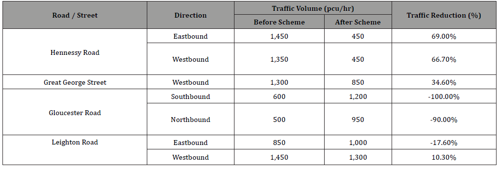

However, as recognized in the assessment, the overall traffic volume in the study area would remain similar to before, if not increased due to a continual growth in the number of registered vehicle in Hong Kong. Hence, the reduction of traffic in those mentioned area is achieved through diversion to some other area. This is shown by an increase of traffic at roads like Gloucester Road, Percival Street and Leighton Road. Traffic changes at key areas are illustrated as in Figure 2.
We shall be using geographical information system and the CALINE4 model to calculate the emission scenarios within the precinct. When evaluating traffic emission, it is often necessary to project the future road emission level. It is assumed that for each type of vehicle, the amount of pollutant emitted will slowly decrease as years go by because older and more-polluting vehicles of the will be put out of service and be replaced by newer and less-polluting vehicles and secondly, emission performance improvement can be achieved in the future. The government’s intervention such as implementing more stringent vehicular emission standard can further catalyse the process.
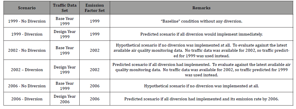
Six scenarios were set up in this study to evaluate and predict the emission rates for the four key roads identified. These scenarios are based on the three different traffic sets predicted in TD’s study and EPD’s different emission factors for different evaluation year. The three traffic sets predicted in TD’s study, namely Base Year 1999, Design Year 1999 and Design 2006, which represented traffic during the design year (1999), the predicted traffic if the scheme was implemented immediately, and the predicted traffic by 2006 (with all diversions implemented) respectively. The six scenarios are summarised in (Table 4).
Table 4:Summaries of evaluating scenarios
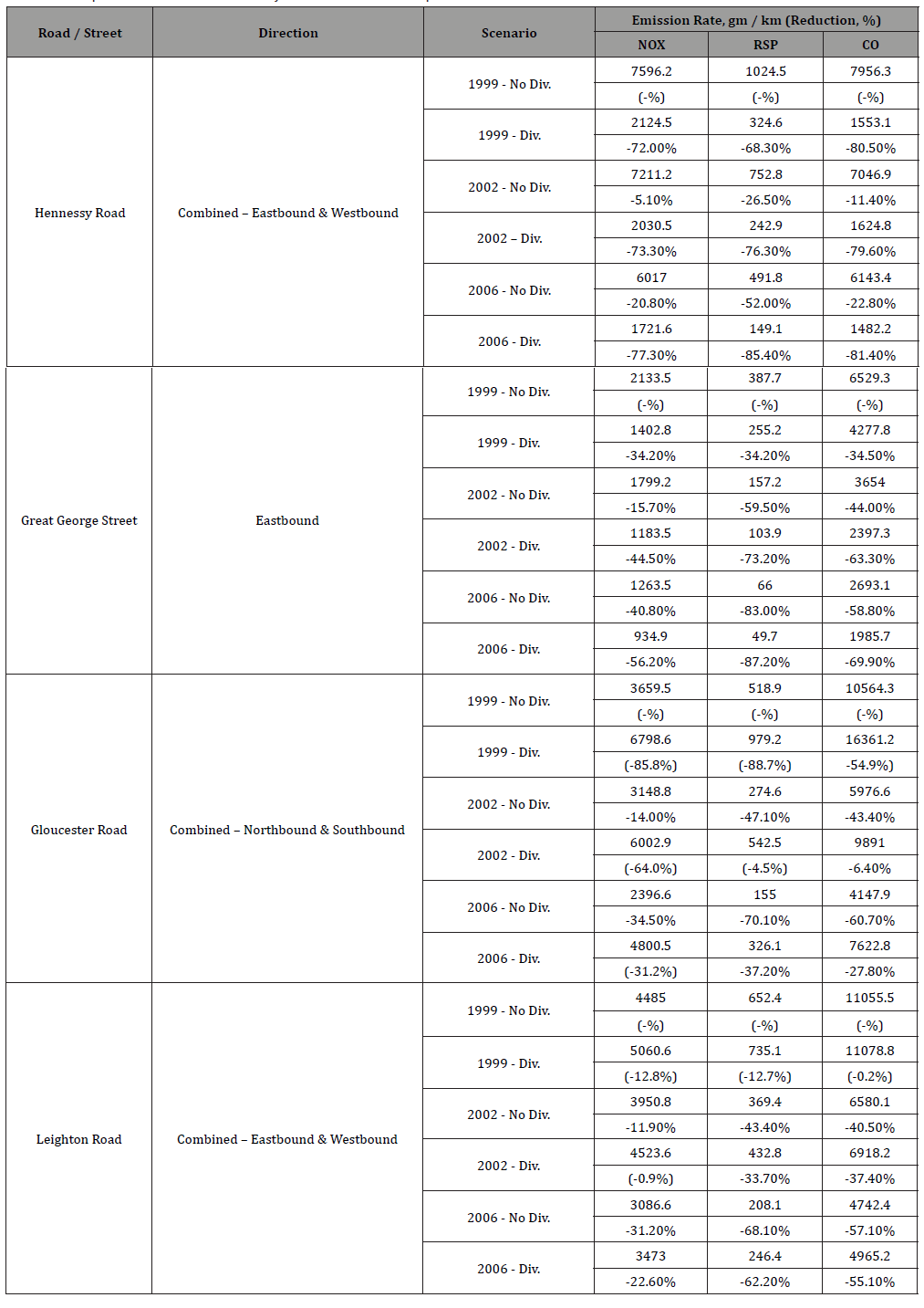
The emission rates and pollution scenarios of Hennessy Road, Great George Street, Gloucester Road and Leighton Road are then calculated in the geographical information system ARCVIEW and are summarised in the Table 5 and Figure 3.
Table 5:Comparison of emission rate at key areas before and after pedestrianisation.
Hennessy road
Substantial reductions are predicted by the implementation of the scheme. Comparing to the baseline emission rate at 1999, a reduction of 72.0%, 68.3% and 80.5% could be achieved for NOX, RSP and CO respectively. The major factors behind such reduction are the restriction of private vehicles off Hennessy Road, and also the re-routing of franchised buses, which reduced both eastbound and westbound by 200 buses per hour. It is predicted in TD’s Study that the traffic in Hennessy Road would remain at 900 pcu up until 2006. Further reductions for all three parameters, due to lower projected emission factors, would thus be expected in 2006.
Great george street
Reductions are predicted by the implementation of the scheme. A reduction of 34.2%, 34.2% and 34.5% could be achieved for NOX, RSP and CO respectively. The major factor behind such reduction is the diversion of traffic away from Great George Street, decreasing its traffic volume from 1300 pcu to 850 pcu. It is predicted in TD’s Study that the traffic in Great George Street would slightly increase to 950 pcu by until 2006. However, improvement in vehicular emission would outweigh this slight increase. By 2006, with the scheme fully implemented, a reduction of 44.5%, 73.2% and 63.3% for NOX, RSP and CO respectively is predicted compared to the baseline emission rate at 1999.
Gloucester road
Unlike the previous two examples, traffic volume is expected to increase by 95.4% (combining both northbound and southbound traffic) after the implementation of Pedestrianisation scheme. To accompany this rise in traffic volume, significant increases for each pollutant emission rate are predicted from the calculation (85.8%, 88.7% and 54.9% for NOX, RSP and CO respectively). By 2006, with the exception of NOX, air quality improvements for RSP and CO are predicted (by 37.2% and 27.8% respectively), compared with the pre-diversion level in 1999.
Leighton road
Similar to the Gloucester Road case, emission rates would have been increased if diversions and re-routings were to be implemented (increase of 12.8% for NOX, 12.7% for RSP and 0.2% for CO). Although the overall traffic volume (combining eastbound and westbound traffic) would remain similar before and after the scheme, due to franchised bus re-routing, it is anticipated an extra 50 bus per hour would travel via Leighton Road, instead of Hennessy Road. The deterioration in emission performance is due to the increase of more-polluting vehicle in the traffic.
Due to the relatively small increase in emission rate, the deterioration from increase of more-polluting vehicle would be overwhelmed by the predicted overall improvement of traffic emission. Moreover, it is predicted by 2006, the traffic volume for Leighton Road would have decreased from 2300 pcu to 2150 pcu per hour. Both factors contributed to the predicted reduction of emission rate of 22.6% for NOX, 62.2% for RSP and 55.1% for CO, compared to 1999 baseline level.
With the overall traffic volume in the study area to remain roughly the same, the original traffic load at the targeted areas is simply diverted to some other areas as in (Table 3). Alleviating the emission problem at targeted areas would result in aggravation at another. Shifting a problem from one place to another need’s justification. The justification of such move lies within the constitution of prioritisation.
One might argue that targeted areas (Hennessy Road and Great George Street) are given priority because improvements could possibly benefit more people. As shown in (Table 6), which summarises the pedestrian count for the four analysed roads / streets, it is obvious that more pedestrians could have benefited from the improvement of roadside air quality.
Table 6:Pedestrian Count in Causeway Bay 1999.

Another argument is that Hennessy Road is a typical example of an urban canyon, with high rise buildings on both side and with small amount of ventilation spaces. Any pollutants released inside Hennessey Road would be difficult to disperse through natural ventilation. On the other hand, Gloucester Road does not suffer the same problem as it faces the harbor directly. Although the emission rate has vastly increased, it would not be trapped inside the region as in the case of Hennessy Road.
In general, it must be accepted that pedestrianisation improves air quality only on a local level as the pollution are simply shifted to other locations. To ensure that Pedestrianisation be justified, the pollution at the sacrificed roads must be able to be dispersed easily (like Gloucester Road) and that the people who benefited from the scheme far outweighs the harm. Our calculations affirm this.
Comparisons with Air Quality Data at Roadside AQMS
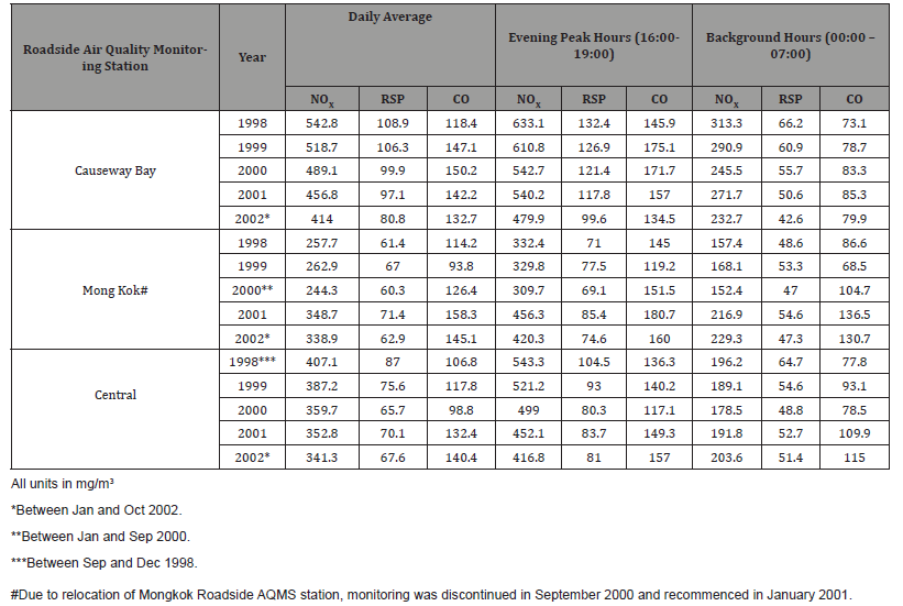
The magnitude of changes in air quality at different roads/ streets within the study area is predicted using computational tools. It is necessary to check whether such prediction is accurate and to confirm that assumptions made are valid. Data obtained at EPD’s Causeway Bay Roadside AQMS, between January 1998 and October 2002 are analysed to provide the magnitude of air pollutants before and after the implementation of the pedestrianisation scheme.
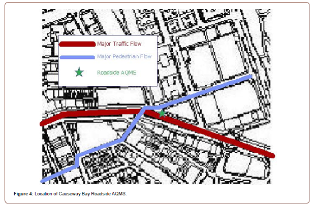
The Causeway Bay Roadside AQMS, as shown in Figure 4 is strategically located at the junction of Yee Wo Street / East Point Road / Great George Street. This location is considered the ‘black spot’ in terms of air quality and is situated at the crossroad between the major traffic flow paths. The major vehicular flow path in the study area is the westbound-eastbound traffic in Hennessy Road / Yee Wo Street; while the major pedestrian flow path is from east end of Great George Street, across Yee Wo Street, into Kai Chiu Road, across Percival Street and into Russell Street.
Out of all the pollutants monitored at the AQMS, NOX, RSP and CO are chosen for analysis because they can represent the level of vehicular pollution. Monitoring data from the other two roadside AQMS (Central and Mongkok) are used as a reference.
Air quality data is recorded on an hourly basis. Data obtained are pooled together into two major groups, to represent different traffic status of the day. The first group is data obtained between 16:00 and 19:00, representing the evening peak hours, while the second group is data obtained between 00:00 and 07:00, representing ‘background’ level. It is assumed that the air quality impact from traffic would be minimal during this background period. Monthly concentration recorded at EPD’s Roadside AQMS is presented and are summarised in (Table 7).
Table 7:Summaries of air quality data at roadside AQMS, 1998-2002 (data courtesy from Environmental Protection Department).
Without going through the technical details of air quality modelling, we can assume that levels of pollutant recorded at the roadside AQMS is proportional to the amount of pollutant emitted from nearby traffic only. It is also assumed that peripheral variables such as geographical and meteorological variation are regarded as constant.
Another hypothesis is that air quality would improve slowly even without any pedestrianisation and re-routing arrangements. As discussed earlier, in general, our vehicular fleet is getting cleaner and cleaner each year, and this is reflected by EPD’s emission factor for each type of vehicle. Hence, the air pollution scenarios without any traffic diversion / reduction are also calculated for reference.
Results of the calculated variable and background level and the reduction air pollution with and without pedestrianisation are summarised in (Table 8).
Table 8:Comparison of Predicted and Measured Air Quality at Causeway Bay Roadside AQMS.


RSP
The predicted concentration with and without pedestrianisation is 84.5 mg/m3 and 108.3 mg/m3 respectively, where the actual concentration is 100.0 mg/m3. There is satisfactory agreement between the computational and field data and shows that the model is acceptable. The scheme has been effective in reducing the pollutant concentration since the magnitude of reduction is greater than by merely improving emission levels alone.
NOX
The predicted concentration with and without pedestrianisation is 458.6 mg/m3 and 619.5 mg/m3 respectively, where the actual concentration being 484.6 mg/m3. The scheme might have been effective in reducing the pollutant concentration. The magnitude of reduction is the greatest amongst the three pollutants and the closest to the prediction with the scheme implemented. However, from the previous section, when compared with the other two roadside AQMS, Causeway Bay has a much higher reduction in NOX concentration. It should be noted that NOX is a photochemical and depends on other factors such as concentration of ozone and hydrocarbons and amount of sunlight.
CO
The predicted concentration with and without pedestrianisation is 101.8 mg/m3 and 145.1 mg/m3 respectively, where the actual concentration is 141.3 mg/m3. The scheme might have been effective in reducing the pollutant concentration since the magnitude of reduction is greater than by improving emission levels alone. From the analysis, it suggests that pedestrianisation scheme has improved roadside air quality along these three streets, as reflected by the data obtained at Causeway Bay roadside AQMS. However, the actual magnitude of reduction is far less than that predicted, showing that improvements on models are needed. The relatively large discrepancy is attributed to the lack of considerations on the chemistries of the pollutants.
Another significant factor which probably has a role to play in the discrepancy is the fact that the predicted traffic flow is quite different to the actual volume in 2002 (assessment year). A number of traffic arrangements and recommendations described in the pedestrianisation scheme have not been fully implemented by 2002. The implementation status of the scheme as at 2002 is enlisted in (Table 9).
Table 9:Pedestrianisation implementation status in Causeway Bay.
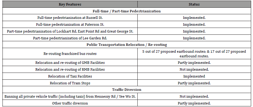
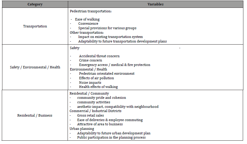
Table 10:Categories of Determining Benefits of Separating Pedestrians and Vehicles.
Other Aspects of Pedestrianisation
Pedestrianisation is a multi-aspect issue, and it affects multiple stakeholders. To evaluate the success of a particular pedestrianisation scheme we refer to the criteria suggested in [5]. Different aspects which are brought upon by pedestrianisation schemes are grouped into three categories, namely Transport, Safety/Environment/Health and Residential/Business as (Table 10).
A simple weighting system is used as a tool to adjust the priority given to each aspect in accordance with different cultural and social background with reference to the scheme in Mongkok and Sparks Street Mall, Ottawa, Canada, which is widely regarded as one of the most successful pedestrianised precincts in North America. Full results are summarised in (Table 11).
Table 11:Evaluation of Causeway Bay, Mongkok and Spark Street Mall pedestrianisation schemes [4].
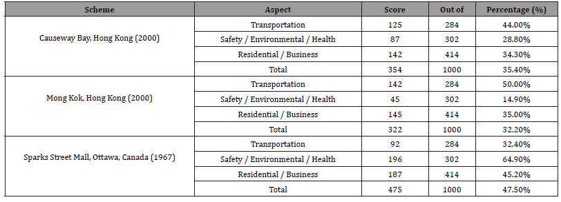
From the results, Causeway Bay pedestrianisation scheme scores a positive mark in each major category and thus shows its acceptability by its stakeholders. Causeway Bay’s score for the ‘Transportation’ category is lower than Mongkok was mainly due to gradient change near Jardine Crescent, Lee Garden Road and Kai Chiu Road, which gives a poor mark in ‘ease of walking’ and ‘special provision for various group’ [7,8].
Transportation is the only category that both Hong Kong’s schemes have scored a better mark than Sparks Street Mall, in ‘convenience’ and ‘impacts on existing transport system’. Hong Kong has a comprehensive transport infrastructure and both areas are served by a diverse number of public transport systems. Although traffic congestions are frequent, majority of people travelled to Causeway Bay and Mongkok via public transport. Street closure in Causeway Bay is limited and has minimal effect to the public transport system.
Causeway Bay scores a much better mark than Mongkok in the ‘Safety / Environmental / Health’ category. This is the category where both Hong Kong’s schemes has fallen far behind Ottawa’s one. Spark Street Mall has much more amenities such as gardens and water fountain and with a lower pedestrian density and better litter control.
Another element that schemes in Hong Kong suffer is the excessive noise levels. This is contributed by high pedestrian density, local businesses and the ‘urban canyon effect’. About 40% of the interviewees admitted that the noise level was critical enough to feel uncomfortable. On the other hand, both Causeway Bay and Mongkok score similar marks under the ‘Residential / Business’ category. While Causeway Bay is regarded to be better aesthetically, Mongkok survey reviews a more significant improvement in terms of retail sales. Shopkeepers reveal that although the pedestrian flow has increased significantly, that did not necessarily result an increase in turnover. At pedestrianised streets, pedestrian prefer to travel in the middle of the street, enjoying this new-found openness. The amount of people walking on sidewalks might have actually reduced.
Conclusion
This study evaluates the possible improvements, in terms of air quality, achieved in accordance with the Causeway Bay pedestrianisation scheme. It concludes that, in accordance with the scheme, air quality improvement, up to 72% in terms of RSP, could be achieved at targeted areas. Even higher reduction is predicted, if accumulating the effect of improving vehicle emission performance.
This study recognises that the Causeway Bay pedestrianisation scheme is much broader than just closing off traffic from one or two streets. It is a regional strategic scheme, which involves traffic diversion and re-routing of public transport system. The objective of these strategic arrangements is to drastically reduce traffic volume at targeted area, such as Hennessey Road. This reduction is proved to be more significant, in terms of air quality improvement, than the removal of traffic at pedestrianised streets.
The improvement in air quality is confirmed by the data obtained from Causeway Bay Roadside AQMS. Between 1998 and 2002, NOX concentration has lowered by 23.7%, while RSP concentration has lowered by 25.8%. This study concludes that such reduction was caused by a reduction of traffic volume in vicinity of the AQMS, as part of the pedestrianisation scheme, and the improvement in vehicle emission performance. However, the improvement recorded is much lower than the predicted one. This might have been due to all measures recommended in TD’s study was yet to be implemented. If all the measures are to be implemented, an even drastic reduction would be achieved.
However, such scheme also has its downside. With the overall traffic volume remained relatively the same, reduction achieved at targeted areas, would result in rise at other areas. Such rise in traffic would be accompanied with a corresponding rise in air pollution. The logics to justify shifting the air pollution from one place to another are: alleviating pollution problem at targeted areas would maximize the number of benefactors; and targeted areas are geographically more confined, pollutants emitted there would build up more easily, resulting in high pollution concentration.
Results from other study have shown that overall Causeway Bay Pedestrianisation Scheme was acceptable in terms of transportation, health, safety, environment and social. Causeway Bay scheme have the advantages of being compact (minimization of impact to existing transportation system) and good public transport infrastructure (convenience and accessibility). On the other hand, in comparison with other schemes, a lack of street furnishing, organized activities and high noise levels mean there are rooms for improvement.
Acknowledgment
None.
Conflict of Interest
No conflict of interest.
References
- Chan AT, Hedley AJ, Hills PR, Zhong J (2001) The Air We Breathe: Air Pollution in Hong Kong, Hong Kong: Hong Kong University Press.
- CH2M Hill (China) Limited (2002) Study of Air Quality in the Pearl River Delta Region, CH2M Hill (China) Limited.
- Ove Arup and Partners Hong Kong Limited (2000) Hong Kong Island North and Kowloon West District Traffic Study: Pedestrianisation Study, Ove Arup and Partners Hong Kong Limited.
- Transport Department (1999) Third Comprehensive Transport Study (CTS-3), Hong Kong SAR Government.
- Roddin M (1981) NCHRP Report 240: A Manual to Determine Benefits of Separating Pedestrians and Vehicles, Transportation Research Board.
- Environmental Protection Department (2001) Air Quality in Hong Kong, Hong Kong SAR Government.
- Lo KW (2002) A Study of Design of Pedestrian Precincts in Hong Kong, Hong Kong Polytechnic University Master Thesis.
- (2005) Transport Department Website.
-
Andy Chan, Kenneth Chow. Pedestrianisation Zoning and Air Quality in Hong Kong . Glob J Eng Sci. 8(2): 2021. GJES. MS.ID.000684.
-
Air quality, vehicular traffic, Transport department, Cleaner and safer environment, Pedestrian, Environmental protection department
-

This work is licensed under a Creative Commons Attribution-NonCommercial 4.0 International License.
- Abstract
- Introduction
- Methodology
- Roadside Air Pollution in Hong Kong
- Pedestrianisation Scheme in Causeway Bay
- Comparison between Predicted Traffic Pollutant Emission and Air Quality Monitoring Data
- Comparisons with Air Quality Data at Roadside AQMS
- Other Aspects of Pedestrianisation
- Conclusion
- Acknowledgement
- Conflict of Interests
- References


