 Review Article
Water Resources of Tajikistan. Climatic Features of the River Basin of the Zaravshan
Davlyatov Rashid Rakhimovich*
Agency for Hydrometeorology of the Committee for Environmental Protection under the Government of the Republic of Tajikistan.
Davlyatov Rashid Rakhimovich, Agency for Hydrometeorology of the Committee for Environmental Protection under the Government of the Republic of Tajikistan. Dushanbe, st. Pulod Tolis, building 12, apt. 3
Received Date:May 16, 2025; Published Date:June 03, 2025
Abstract
The analysis of background temperature and precipitation was conducted based on meteorological measurements in the upper, middle and lower reaches of the Zarafshan River in the Zarafshan Glacier basin. In this study, long-term historical data were used, where the following meteorological stations operate in the mountainous area of the river: Dehavz (international code 38734) - upper reaches, Madrushkat (international code 38725) - the middle zone of the river; Sangiston (international code 38716) - lower reaches of the river.
The study showed that meteorological data at different altitudes are different and change depending on the altitude of the local mountainous relief. The influence of warm background temperature on the snow accumulation zone in the upper reaches of the Zaravshan River (Zaravshan Glacier basin) was revealed [1-3].
Keywords:Snow cover; Precipitation; Temperature; Trend; River basin, Glacier, Degradation, Low water
Introduction
Tajikistan has a continental climate, with dry air and little cloud cover. Climate change in Tajikistan is no longer a forecast for the future, but an increasingly tangible reality. Geographical features make Tajikistan the most vulnerable to climate change in Central Asia.
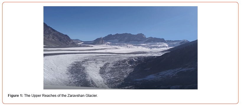
The Zaravshan Glacier is the largest valley, tree-like glacier in the Gissar-Alay Mountain system. It gives rise to the Matcha River, the source of the Zaravshan River. The first mentions of the Zarafshan River can be attributed to the times of the 4th-2nd centuries BC, to the historical time of “Sarazm”.
The large dendritic Zeravshan glacier lies in the upper reaches of the valley of the same name between the southern slope of the Turkestan ridge and the northern slope of the Zeravshan ridge, so the exposure of its individual sections is very diverse: southern, southeastern, southwestern, western.
The glacier consists of the main stream and about two dozen tributary glaciers. Its slide first flows to the south, and then near the Matcha Pass turns to the west. The glacier receives its main nutrition from tributaries originating on the southern slope of the Turkestan Range - these are complex valley glaciers located in transverse valleys - the Tolstova, Skachkov and other glaciers. The left tributaries descending from the northern slope of the Zeravshan Range are small and steep. The comparatively narrow and long tongue of the Zeravshan Glacier with an average surface slope of about 8° descends to an altitude of 2810 meters above sea level, where water flows out of an ice grotto, giving rise to the Zeravshan River. At the same time, we note the comparatively small firn area of the glacier [4-6].
Study Area
To conduct the study, meteorological data from existing stationary weather observation facilities built along the course of the Zeravshan River were used.

Dehavz meteorological station (39o26/38//N, 70o13/20//E).
Dehavz station was opened in 1928 and is located at an altitude of 2564 meters above sea level. The station is located in the spurs of the southern slopes of the Turkestan ridge, in the upper part of the valley of the Zeravshan River. The terrain is mountainous, heavily indented. 10km to the east there is a glacier feeding the Zeravshan River. At present, the distance of the glacier from the meteorological station has increased due to its strong melting.
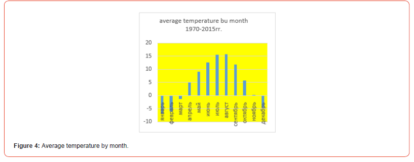
The territory of the Dehavz station is located in a zone of insufficiently humid climate with warm summers and moderately mild winters. The duration of sunshine is 2097 hours per year. The frost-free period lasts on average 152 days. The average annual temperature is plus +4.3°C degrees Celsius. The average temperature of the coldest month of January is minus - 7.1°C degrees Celsius. The average minimum air temperature is minus -10.9°C degrees Celsius, but with the invasion of large cold air masses it can drop to minus -26-29°C degrees Celsius. At the same time, during the daytime in the winter months on some days the air can warm up to +6+8°C degrees Celsius.
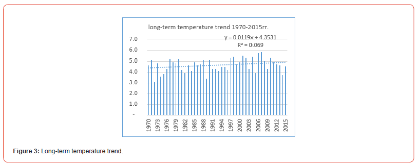
The average temperature of the warmest months of the year - July and August, is +15+16°C. In the hottest months, during the daytime the air warms up to plus +20+25°C, and the absolute maximum is plus +28°C. At the same time, if the average minimum temperature in the summer months is plus +6+9°C, then in the coldest years on some days it can drop at night to minus -2°C. It should be noted that against the background of a positive trend, according to long-term data, there were years with a relatively low average annual temperature (Figure 3).
At an altitude of more than 2500 meters above sea level, the calendar winter persists. Only four months of the year showed long-term negative average daily temperatures of relative cold (Figure 4). The month of November has already turned out to be critical in the year with a relative temperature of plus +0.01°C heat.
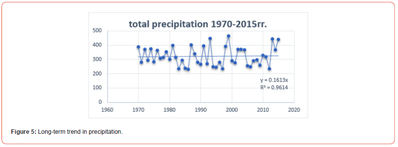
The Dehavz weather station is characterized by an annual precipitation cycle with a maximum in April-May and a small amount in August-September. It can be said that the main amount of 47% falls in the spring, 12% falls in the winter months, 13% in autumn, and 28% in summer from the annual precipitation. The annual precipitation is 315mm. The total precipitation for 45 years was 14785.3 mm and there is a positive trend of a slight increase.
The average annual relative humidity is 50%, and the average monthly ranges from 39 to 56%.
The appearance of snow cover is possible already at the beginning of September, but permanent snow cover is established in the first ten days of November. The average ten-day height of snow cover is 1-3cm. According to long-term observation data, the greatest height of snow cover was 33cm. The beginning of moisture saturation and melting of snow cover falls on the middle of February.
In some years, snow cover can be observed until mid-May. In recent years of observation, the height of the snow cover in winter, according to the head of the meteorological station, does not exceed 10cm, which is quickly blown away by gusts of wind. Route snow measurement work in mountainous areas has practically ceased due to the unstable minimum amount of snow cover.
In the Dehavza region, easterly winds prevail (55% of the total number of cases). The average monthly wind speed, throughout the year, is 3-5 meters per second. The maximum recorded wind speed was 35 meters per/second [7-9].
Meteorological station Madrushkat (39о 26/ 47// N, 69o39/52//E).
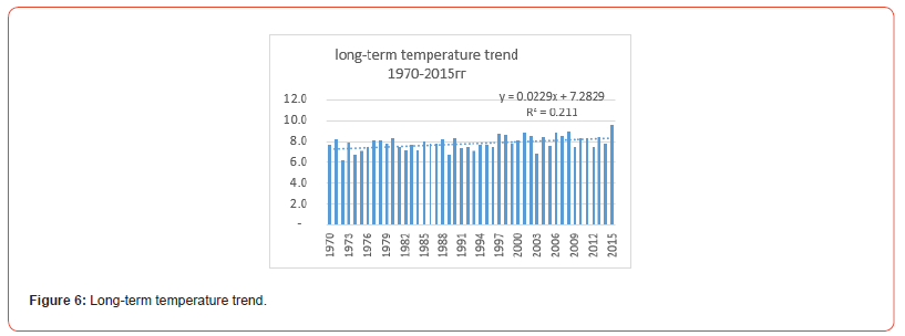
Meteorological data MS Madrushkat height 2254 meters above sea level. The Madrushkat station was opened in 1932. The station is located in the spurs of the southern slopes of the Turkestan ridge, in the valley of the Zeravshan River. The terrain is mountainous. The territory of Madrushkat is located in a zone of insufficient humidity with warm summers and moderately mild winters. The average annual temperature is +7.4°C. The frost-free period lasts on average 180 days. The average temperature of the coldest month is January - 4.1°C below zero. The average minimum air temperature is -8.0°C below zero, but with the invasion of large cold air masses it can drop to -28-30°C below zero. At the same time, during the day, the air in the winter months on some days can warm up to 0-12°C above zero. The average temperature of the warmest months of July and August is +18+19°C. In the hottest months, the air warms up to +22+27°C during the day, and the absolute maximum recorded is +34°C. At the same time, if the average minimum temperature in the summer months is +6+9°C, then in the coldest years on some days it can drop to 0°C at night. The long-term temperature trend shows a positive balance of temperature growth (Figure 6), but the calendar winter in the Madrushkat area persists and the negative balance of temperature is noticeable (Figure 7).

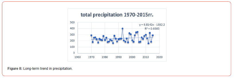
Madrushkent is characterized by an annual course of precipitation with a maximum in April-May and a small amount in August-September. The main amount of 49% falls in the spring, 12mm falls in the winter months, 13mm in the fall, and 26% of the annual precipitation in the summer. The total amount of precipitation per year is 225mm.
The total amount of precipitation over 45 years was 11047.7mm, which is of course significantly less than in Dehavz.
The average annual relative humidity is 44%, and the average monthly fluctuates between 35 and 49%. Snow cover may appear as early as early October, but permanent snow cover, according to long-term data, may be established as early as the first ten days of December. The average ten-day height of snow cover is about 1cm. The greatest height of snow cover was 8cm. Snow cover melts in mid-February. In some years, snow cover may persist until early May.
In the Madrushkat area, easterly winds prevail (45% of the total number of cases). The average monthly wind speed is 2.3-4.0 m/sec throughout the year. The maximum wind speed is 28 m/sec [7-9].
Meteorological station Sangistan (39о23/30//N, 69o39/52//E).
The station was opened in 1932. The station is located in the spurs of the southern slopes of the Turkestan Range, in the valley of the Zeravshan River. The height of the station is 1502 meters above sea level. The territory of Sangistan is located in a zone of insufficiently humid climate with warm summers and moderately mild winters.
The average annual temperature is +11.4°C. The frost-free period lasts on average 214 days. The average temperature of the coldest month of January is -2.0°C below zero. The average minimum air temperature is -5.2°C below zero, but when large cold air masses invade, it can drop to -24-26°C below zero. At the same time, during the daytime in the winter months, on certain days, the air can warm up to +9+20°C above zero.
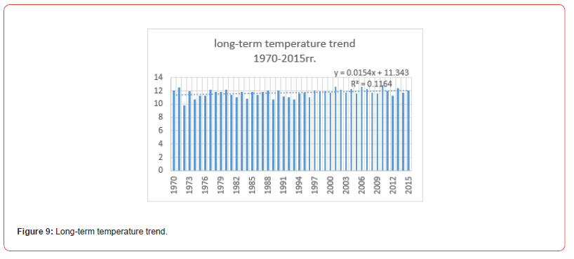
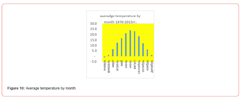
The average temperature of the warmest month – July is +24.0°C. In the hottest months, the air warms up to +25+30°C during the day, and the absolute maximum is +40°C. At the same time, if the average minimum temperature in the summer months is +13+15°C, then in the coldest years on some days it can drop at night to +2+5°C.
The annual precipitation is 193mm. Sangiston is characterized by an annual precipitation cycle with a maximum in April-May and almost complete absence in August-September. The main amount of precipitation - 52% - falls in the spring, winter, summer and autumn months account for 15-17% of the annual precipitation.
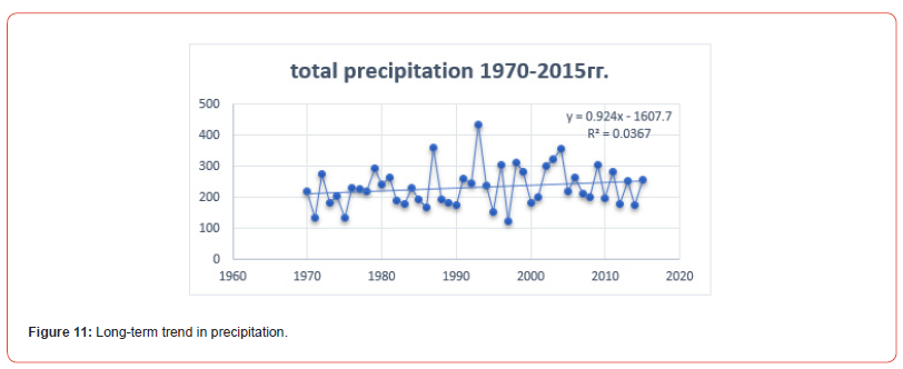
Snow cover appears in early October and is unstable until the end of December. The average maximum ten-day snow cover depth is 3cm, the greatest snow cover depth was 13 cm. The snow cover begins to melt in mid-February.
The average annual relative humidity is 44%, and the average monthly ranges from 30% to 52%.
In the Sangistan region, westerly and south westerly winds prevail (24% of the total number of cases). The average monthly wind speed fluctuates from 3.3 m/sec in warm weather to 2 m/sec in cold weather. The recorded annually recurring maximum wind speed is up to 20 m/sec [7-9].
Discussion
In my study, the analysis of meteorological data for the period 1970-2015 revealed that the trend towards increasing seasonal air temperature at all three stations persists. In the winter season, the cold temperature background actually retreats, which affects the preservation of the snow cover that accumulates in the highmountain zone of the Zaravshan glacier [8].
Regarding the past 2024, which was assessed as the warmest year, according to long-term meteorological observation data, it is necessary to note the increase in the temperature background in the high-mountain zone of the Zeravshan glacier basin. At the same time, unstable precipitation is noted in four seasons: in winter - relatively small amounts, in the spring-summer-autumn periods in the high-mountain zone, their positive balance is noted for an increase in the form of rain.
Conclusion
A study of the temperature background using meteorological data from high-mountain stations on the Zaravshan River as an example showed that the following situation is observed in the accumulation zone of the Zarafshan glacier [10].
- at an altitude above 2500 thousand meters (Dehavz station) the temperature increases as such is not particularly noticeable. And the negative temperature lasts for four calendar months of the year: December, January, February, March. The month of November became a turning point, when the positive temperature trend began to prevail over the negative temperature of the cold. Precipitation in the high-mountain zone of the Zaravshan River basin begins to recover - this is evident from the graph of long-term data. However, it is very difficult to track the height of the snow cover in the winter at this time, due to the fact that freshly fallen snow is blown away by gusts of wind and only a small part of it remains on the glacier plateau.
- At an altitude of 2000 meters, a completely different picture is observed. Thus, negative temperature readings are maintained only in the winter season, which is only three months a year: December, January, February. Regarding the depth of the snow cover, the information is unstable, since the region itself has little snow and, according to long-term data from the Madrushkat station, there is no tendency for improvement. Considering the temperature increase, it can be said that the snow cover in recent years did not have a permanent base - it melted, and the calculation of the moisture content in it was practically not carried out. Here it is also necessary to say about the route snow works, which were also not carried out due to the small amount of precipitation and the lack of a permanent snow cover, the height of which did not exceed 1-4 cm.
- and the most “critical” assessment at an altitude of 1500 meters above sea level. According to meteorological data monitoring, the prevalence of a positive air temperature trend is obvious. The winter cold weather period is only a little more than half of January, the rest of the year there is a stable positive temperature trend. The snow cover formed from wet snow in the winter is not constant. Prevailing precipitation in the form of rain manages to wash it away almost completely.
Let us summarize the results of the general monitoring of temperature, precipitation and snow cover observed in the Zeravshan River basin. “Global warming” is already actually observed at altitudes above 1500 meters (above sea level), but in the upper reaches above 2000-2500 meters, the climatic winter period is still stable, and precipitation in the form of snow has its own small positive accumulation period. The amount of precipitation in the form of snow is so small that it has ceased to affect the water flow of the Zeravshan River, while the plateau of the Zeravshan glacier is melting with progressive growth. In recent years of observation, this has become a very significant problem. The thickness of the ice, annually, sharply decreases and the ablation point of the glacier in the coming years will change. The water flow of the Zeravshan River, which belongs to the Amu Darya River basin, will continue to decrease. During the low water period, the water in the riverbed becomes so small that the once full-flowing Zeravshan River, on the banks of which such ancient cities as Samarkand and Bukhara (on the territory of the Republic of Uzbekistan) were built, is now literally - there is no water!
There are no water-saving reservoirs on the Zaravshan River, and the water in the riverbed flows as its natural runoff. The construction of artificial water reservoirs is becoming a priority task, which will help regulate water flow and accumulate natural precipitation. At the same time, timely hydrometeorological information on changes in temperature, precipitation and snow reserves in the mountainous region will significantly facilitate the life and work in the field of local farmers living in the Zaravshan River basin [1-4].
Acknowledgement
None.
Conflicts of Interest
No Conflict of Interest.
References
- Statistic RT (2008) Statistic RT: Dushanbe, Tajikistan, p. 82.
- Atlas (1968) Atlas: Dushanbe, Tajikistan, p. 199.
- Nazirova D (2016) Science and Innovation: Dushanbe, Tajikistan pp. 89-92.
- Scientific Notes (1959) Essays on the Geography of Tajikistan [Text]/Scientific Notes, Vol. XXI; Geographical Series: Stalinabad, Tajikistan pp. 8-58.
- Gulakhmadov A, Chen X, Gulahmadov N, Liu T, Davlyatov R (2020) Long-Term Hydro– Climatic Trends in the Mountainous Kofarnihon River Basin in Central Asia. Water 12, 2140: pp. 2 -20.
- Second National Communication of the Republic of Tajikistan under the UN Framework Convention about climate change. Dushanbe, 2008, p. 93.
- Third National Communication of the Republic of Tajikistan under the UN Framework Convention climate change. Dushanbe, 2014, p. 167.
- Archival data of the Agency for Hydrometeorology of the Committee for Environmental Protection under the Government of the Republic of Tajikistan.
- Archival data from the author's library.
- Archival data from the Dehavz meteorological station, the Madrushkat Weather Station, meteorological station Sangistan.
- Catalog of Glaciers of the USSR. Catalog of Glaciers of the USSR. T. 14. Central Asia. Issue 3. Amu Darya. Part 5. Basin of the Kofirnigana River //V.I. Kvachev, A.G. Sannikov, L.N. Sokolov; Gidrometeoizdat: Leningrad, Russia, 1968; p. 44.
- Third National Communication of the Republic of Tajikistan under the UN Framework Convention climate change. Dushanbe, 2014., p.167.
-
Davlyatov Rashid Rakhimovich*. Water Resources of Tajikistan. Climatic Features of the River Basin of the Zaravshan. Glob J Eng Sci. 12(1): 2025. GJES.MS.ID.000780.
-
Climatic features, Temperature, Meteorological data, Climate change, Wind speed, Temperature growth, Meteorological station, Moisture saturation, River basin
-

This work is licensed under a Creative Commons Attribution-NonCommercial 4.0 International License.


