 Research Article
A Systematic Review of Existing Methods plus the State-of-the-art Technologies Used to Collect Road-Related Data and its Usage
Bosong Jiao, University of Birmingham, UK.
Received Date: February 15, 2022; Published Date: March 22, 2022
Abstract
Road networks are an essential component of infrastructure. In order to improve the performance of road networks, the existing (business as usual) data collection methods are critical for management staff. However, with the development of big data and technologies, advanced devices and analysis methods appeared in research area and industries. These technologies are more cost-efficient and intelligent to collect and analyze data. Therefore, there is a need to review the existing data collection methods and explore the state-of-the-art technologies regarding data gathering to figure out how best they can be used. This systematic review has been conducted to identify the technologies and data usage by answering two primary questions: 1) What is the evidence to support the use of existing data collection methods for the road sector? 2) What is the evidence to support the state-of-the-art technologies being used for road-related data collection and analysis? There is sufficient evidence to describe the existing data collection methods. Based on these methods, different devices and novel analysis methods are presented by researchers used for accurate and comprehensive data collection, which involves traffic management, road maintenance and road safety. However, the review discusses the limitation of each independent technologies and the significance of interdisciplinary collaboration, which requires more expert knowledge to achieve high quality implementation.
Keywords: Road data collection; State-of-the-art technologies; Traffic; Road maintenance; Road safety
Introduction
Smart road networks involving traffic management and road asset management, have a strong ambition to relieve issues and improve the satisfaction of living and travelling [1]. The increasing demand for the road network and deterioration on road conditions calls for an efficient digital transformation of road data collection, analysis, integration, and deployment. It is a global issue that nearly three-quarters of cities across the world have either increased or stable congestion levels between 2017 and 2018, resulting from a rising demand in travelling [2]. The other issue is the emphasis on road work, which has changed from construction to road management, particularly in maintaining them due to the road pavement deterioration [3].
Data collection plays a predominant role in the advanced digital transformation of the road sector, which determines the reliability and efficiency of management. The traditional road-embedded and road-side sensors are valuable, but these are limited in terms of coverage and the high-expenditure on installation and maintenance [4]. Thus, state-of-the-art technologies that could be applied to road related works, are required to implement broad-scale and real-time data collection. There is a future exploring area concerning the extent to which cost-efficient technologies can be utilized and how these technologies can be successfully implemented. Identifying various existing and state-of-the-art technologies regarding road data collection is urgently needed. This systematic review focuses on road related data and aims to identify both traditional collection methods and new technologies used in the road sector. Through scrutinization and coding of the eligible studies, the robust of the evidence will be assessed and synthesized to provide a better understanding of road related data to management staff.
Methods
A systematic review is one of the secondary research methods demonstrating and analyzing the research field based on the review of existing research with the purpose of answering a specific question. It involves four crucial stages: 1) clarifying the primary question, 2) screening and identifying relevant studies, 3) quality assessment and 4) bringing findings together as synthesis [5].
This review will address the following principal questions:
a. What is the evidence to support the use of existing data
collection methods for the road sector?
b. What is the evidence to support the state-of-the-art
technologies being used for road-related data collection and
analysis?
Definition
While “Technology” refers to “methods, systems, and devices that are the result of scientific knowledge being used for practical purposes” [6], “State-of-the-art” is defined as “very modern and using the most recent ideas and methods” [7]. In this paper, state-ofthe- art technology is considered as the most recent ideas regarding data collection methods, the devices used in a very innovative way and the novel data analysis systems, which appeared in the past decade, or the technology appeared earlier but applied to road data collection in recent decade associated with the smart road network. Thus, the state-of-the-art technology is taken to include:
1. Devices of data collection
2. Novel system of data collection and analysis
Search strategy
Search approach: A comprehensive search strategy is required to achieve the goal of scrutinizing new technologies by searching across multiple sources including electronic searches, website searches, citation chasseing. The systematic reviewer 4 (EPPI-reviewer 4) application is used to simplify the process in terms of duplicate checking, screening, coding, analyzing and storing retrieved document, which enables to build a structure of evidence to answer the primary question [8]. The summary of the searching process is illustrated in Figure 1. Furthermore, literature and on-going/completed projects were also integrated to gather international evidence.
Search terms: The search terms are applied to the search engine and databases in order to identify relevant studies, which are developed by the consideration of the specific-subject background and primary questions of the review. The synonym and search strings are two main clues of search terms, as following: Road-related data, smart road network, road data collection intelligent traffic management, traffic data collection road asset management, road maintenance, road safety state-of-the-art technologies, cutting-edge technologies, new technologies, smart technologies
Sources: The review acquires evidence from different sources involved in the road sector, electronic databases, internet search engines and citation chasing. There are a number of electronic databases on the website belonging to different organizations available for students at the University of Birmingham. The studies were obtained from Transport Research International Documentation (TRID), Australian Road Research Board (ARRB), IEEE Digital Library (IEEE), ScienceDirect, Springer Link and SAGE Journal. TRID is the largest online databased of transportation research. ARRB is the national transport research organisation. IEEE is the largest technical professional organization for the advancement of technology. These databases provide a large scale of expert knowledge with high reliability to ensure the quality of review involving specific professional technologies. In addition, citation chasing was also carried out using search engines such as Google Scholar and FindIT.bham.ac.uk.
Weight of evidence: quality and relevance assessment
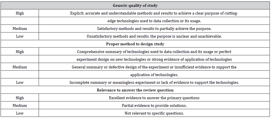
A weight of evidence framework, a technical tool of the systematic review, aims at assessing the quality and relevance of studies based on three criteria: 1) generic quality of study, 2) proper method to design study and 3) relevance to answer the review question [5]. It helps to consider different judgments on general and specific criteria and then to combine them to make an overall judgment on how these studies contribute to answering the primary questions [9], so the overview of the criteria is illustrated in Table 1. These studies which achieve at least two high ratings and a medium rating in the three criteria were taken into account to proceed.
Synthesis of evidence
The synthesis is the key component of systematic review, enabling a conclusion of the main findings. The narrative synthesis is used in this report to describe the state-of-the-art technologies used to collect data and application of data, which enhances the road performance in terms of traffic, operation and maintenance. There will be four main elements [10]:
• Developing a theory of how the intervention works
• Developing a preliminary synthesis of findings of included
studies
• Exploring relationships in the data
• Assessing the robustness of the synthesis
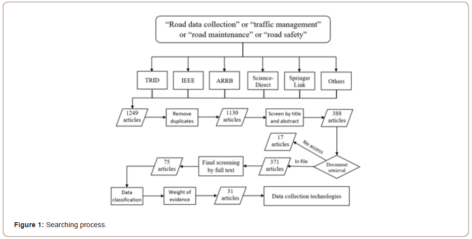
Table 1:Weight of evidence (Gough et al., 2017).
Literature Review of Findings
There were 75 relevant articles to the objectives of review, derived from 1249 articles which were screened, removing duplicates as well as screening the abstract, title and the full text. These studies are grouped and classified according to the technology and data orientation. After shortlisting the same technology and the specific demonstration of technologies, there were 31 representative articles which provide robust evidence that could be summarised and scrutinized as a synthesis to achieve the goal of answering the primary questions (see Appendix). All 31 articles were published by transport and computer authoritative journals or by the international conference. The review includes the technologies and data usage from different countries in the world such as USA, UK, China, Australia, Malaysia, providing a good quality of international evidence to support the quality of the systematic review. Based on different data types and attributes, there are 4 broad data categories identified: 1) traffic-related onroad information, 2) data related to road condition analysis and maintenance, 3) road safety related information and 4) social media source. The remaining sections will make an overview and compilation of these studies covering existing data collection methods and advanced data collection and analysis.
Traffic-related information
Given that traditional traffic management has been evolving gradually to intelligent traffic management, accuracy of realtime data collection and the efficient analysis methods is more important than ever before. The existing traffic-related data usages are summarised, and 10 articles associated with novel collection technologies are classified. The summary of data types collected from various technologies is illustrated in Table 2 (Table 2).
Table 2:Data types and technologies regarding traffic information.

Imagery is a widely used form of data collection on urban roads, motorways and other types of roads for traffic control purposes. The videos and images can be captured by stationary cameras, which are usually installed on tall poles next to roadways or traffic signal mast arms. The imagery data is usually applied to static object detection and recognition as well as moving objects’ detection, counting, tracking, and classification [1]. However, the inspection scale of point camera is limited and the accuracy of data from traditional cameras can be affected by the illumination and weather condition.
The study of Ghosh et al. [11] developed an adaptive traffic monitoring system based on computer vision technology by utilizing point cameras to detect, classify, count and measure the speed (km/h) of vehicles at specific road sectors. Given that the shadow is likely to be recognised as a vehicle due to the reflection and the different lighting situations, the system considers the shadow effect on data accuracy by background subtraction algorithm based on computing techniques to achieve efficient traffic management. Camera mounted on vehicle was introduced by Namazi et al. [12], who proposed a system to detect the distance between vehicles and the speed of vehicles from multiple lanes. This dynamic detection achieves a large-scale inspection, which can detect the actual state of vehicles and the traffic condition on a real-time basis.
Traditional sensors, such as an inductive loop sensor, are used to collect data based on the electromagnetic induction principle, which can directly measure the presence and occupancy of passing vehicles. The data collected by sensors can be deduced to obtain the density of road and the speed of vehicles. the magnetic sensor is another device used to detect and classify vehicles, which can be deployed quicker and provide additional data for multiple levels of classification. The data can be extracted to obtain the information regarding vehicle number counting, speed of vehicles and classification. This could be applied to traffic signal control and realtime traffic condition monitoring [1]. Magnetic sensors have been used for years since 2008 after being introduced by the research group of Haoui. However, Velisavljevic et al. [13] proposed a system using a pair of magnetic sensors rather than discrete sensors to record signatures for speed detection and vehicle classification. These signatures were analysed by extracting the location of the signature beginning and end timestamps. They developed a novel method by measuring the time delay between the pair of magnetic sensors to estimate the speed of vehicles. The length of vehicles could be calculated by the analysis of the beginning and end indices from the pair of sensors based on the speed estimation.
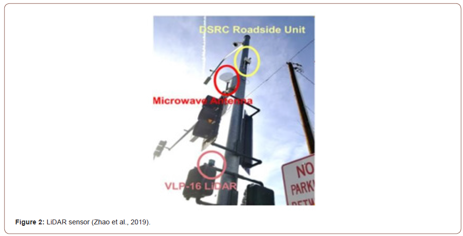
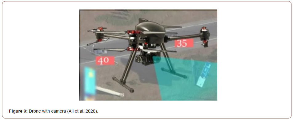
LiDAR is a widely used technology, however it was only introduced into road-related works recently. Zhao et al. [14] put forward a systematic approach to detecting and tracking the movement of both pedestrians and vehicles based on LiDAR (see Figure 2). The outcome of the procedure provides the presence, position, velocity and direction information of pedestrians and vehicles regarded as valuable information for traffic management staff. Ali et al. [15] developed a multimodal vehicle detection by fusing 3D LiDAR and colour camera to provide the multimodal data including colour images, LiDAR range and reflectance data. The misdetection and error rate are reduced by this multimodal method to achieve a more accurate detection (Figures 2,3).
While the smartphone is a common and cutting-edge tool for daily communication. It is also a reliable source to record spatiotemporal movement of individuals by GPS technology. Traffic parameters, such as origin- destination (OD) trip matrix, travel time, speed, traffic flow, traffic density and traffic condition can be estimated by processing the raw data based on statistic and computer techniques collected through cellular network usage [1]. Three articles [ 16- 18] demonstrate these new methods to collect traffic-related information. Floating car data (FCD) is created by the prevalent navigation software embedded in the smartphone, which covers a wide range of scope on geography depending on the movement of vehicles. Wang and Hu [16] presented a project applying FCD to traffic monitoring to improve traffic flow and enhance the efficiency of the road network, which utilized taxis as an intermediary to carry and exchange traffic information. Based on FCD from the taxis, the average speed can be calculated at each road link, which indicates that it is an interesting and effective way to estimate the traffic flow. Another paper demonstrated a fourstage semi- automatic method for the level of service estimation proposed by Axer and Friedrich [17], which succeeded in the trial at the network of Hanover and the surrounding area in Germany. They put forward a georeferencing system of traffic-related information, which was applied to calculate the driving speeds of cars and establish a process with a digital road network. By employing a matching algorithm, the driving direction was detected for those low-frequency floating car data. They developed an indicator to describe a level of service by conducting a systematic and statistical analysis of recorded driving speeds.
The smartphone sensors Bluetooth is another tool to provide a set of applications for a personal area network. Bluetooth Low Energy (BLE) technology is introduced in the automotive industry, which is studied by the research team of Gheorghiu [18]. They proposed a BLE application to collect information about passengers’ activities and detect the communications in a road junction carried out in Bucharest. Based on the time of detection and the certain distance between detectors, the speed of the recorded vehicle was calculated. The preferred direction and favourite position could be determined by summarizing the number of vehicles detected by three sensors. Unmanned aerial vehicles (UAVs) technology provides a remedy for traditional mobile vehicles to avoid potential risks of traffic order and to cover a larger scale of inspection (see Figure 3). Considering its low- cost, remote and broaden-view attributes, it is an interesting solution for traffic management. Two studies [19,20] assessed the performance of traffic management by using UAVs technology. Elloumi et al. [19] proposed a method based on UAVs trajectories for traffic information collection by organizing multiple cooperative UAVs, which has a better performance regarding the coverage and event detection. Ali et al. [15] proposed a traffic surveillance system by combining UAVs and 5G technology. The detection of speed and driving violation on highways can be recorded whilst the system will send alerts to the drivers. For better data coverage with very low latency, 5G technology is used to guarantee fast and reliable communication. The projected result is positive, but this system still needs improvement and application in the real environment.
Data related to road condition analysis and maintenance
Gwilliam & Shalizi [21] mentioned that the failure to invest in maintenance will result in another triple expenditure for road users. Road condition analysis and maintenance is a fundamental work to improve the performance of the road network whilst it has a significant impact on road users. There are 12 articles identified in this section with the aim of providing an overview of existing data collection methods related to road asset management and innovative technologies used to collect information. The data types and technologies are summarised in Table 3.
Table 3:Weight of evidence (Gough et al., 2017).

Imagery is not only used in traffic management, but it is also employed in road asset management, which is used to record the asset inventory and road condition data. The main features of the pavement surface including uniformities of grey value (indicator of brightness of pixels), geometric shapes and texture are the parameters of classification [22]. However, the image process and the analysis methods are still explored for high-speed demand with the development of machine learning and deep learning. There are two articles providing robust evidence of data analysis methods associated with 3D visualization and deep learning. Two studies of Laura [23] and Xia [24] are developed regarding imagery technology for pavement distress detection based on 3D reconstruction and Deep Conventional Networks, respectively. The research team of Laura [23] presented an innovative and low-cost technologies to assess the performance of road pavement. Structure from Motion is a state-of-the-art photogrammetry technique allowing to create 3D models from a photo dataset so that the cracks images can be captured by camera whilst the 3D model can be set up by it. The location, metric information of cracks and the crack profile can be visualized by this system. Xia [24] proposed a method to detect and evaluate the road pavement defects by using car equipped with HD video. The Conventional Neural Network for object detection is used to locate and classify the different kinds of defects including cracks, breaks and potholes. Besides, the severity level of defects can be ranked by the calculation of the range of the defects (Table 3). Acoustic principle is applied to examine the thickness of the asphalt concrete layer of a road [25], but there is insufficient evidence to examine the pavement cracks. Acoustic and frequency analysis is introduced to road condition monitoring. The research team of Rosario [26] presented a novel method using a microphone to collect the vibration and sound waves from the pavement, which was used to detect the state of the pavement by the principle that the spectral content of an acoustic signal differs. The in-lab tests prove the feasibility of this new method, though a more comprehensive study is needed.
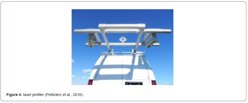
As water and icy conditions may cause potential accidents due to the slippery surface, there are some devices based on technologies such as Multispectral, polarization optics and camera to achieve an accurate road condition classification. The study of Khan et al. [20] is based on the principle of vibration frequency fused with optical theory. The piezoelectric sensor is used to measure the thickness of ice and water film on the pavement surface whilst the optical sensor as a complementary technology designed for snow detection through the analysis of reflection. This combination extends the function of each other achieving the goal of detecting and identifying the road operation condition. Laseroriented systems are developed quickly in the market. The laser crack measurement system proposed by Laurent et al. [23] lay a solid foundation of laser used in the road sector. It creates the laser profiler enabling to measure the road profile regarding the road surface conditions. There are three studies focusing on the supervision of transverse profile, roughness detection and road inventory recording. Both the research team of Petitclerc [27] & Li [28] proposed a method for road surface condition assessment by using vehicle-mounted laser. Petitclerc et al. [27] proposed a novel method to collect the real 3D data of road condition by combining two laser profilers (see Figure 4) and a highly accurate Global Navigation Satellite System-Inertial Navigation System, which could provide an accurate measurement of road surface condition and an accurate terrain map or road. Considering the research of Li et al. [28], they proposed a robust and comparatively low-cost point laser system for local road inspection, of which procedure includes prepossessing and histogram analysis. The principle of the system by using the laser is to measure the time of reflection to identify the location of fretting and the amount of fretting based on histogram analysis, which reflected the roughness of the pavement in turn. Besides, laser can be used to detect road markings which is a necessary component in road inventory data. The detection of road markings has significance in road maintenance considered as the critical tool to provide users with road guidance. Zhang et al. [29] presented using the laser scanner to record and store the profile of the pavement. In order to obtain the transverse pavement consecutively, the laser was mounted on a vehicle. The road-marking information is obtained from the processed 3D data including location, length, width and the elevation (Figures 4,5).
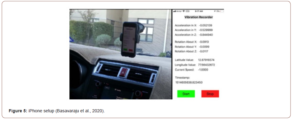
With respect to road deflection, the traffic speed deflectometer (TSD) and falling weight deflectometer (FWD) are mature technologies which have been used by companies and road agencies to evaluate the state of the structure. The data from deflectometer can be used to analyse the property of pavement material and to calculate the delectation of the road, which reflects the health state of the road structure and the potential risk of road performance. Lee et al. [30] presented a novel method to analysis pavement deflection data based on the Neural Network. Based on the data from traffic speed deflectometer as inputs to build a model, a better understanding of TSD as outputs is provided to identify the pavement defects. Considering the advantage of the smartphone sensors such as GPS and accelerometer, 2 articles researched by Singh et al. [31] and Basavaraju et al. [32] are identified. The conception of ‘smart-patrolling’ is developed by the research team of Singh [31], which is proposed to detect and identify the potholes and bumps of the road by using an accelerometer equipped on a smartphone. It was designed based on the significant changes in the readings of the accelerometer. Based on the car equipped with iPhone and the vibration recording application to obtain the data from accelerometer, gyroscope and GPS (see Figure 5), Basavaraju et al. [32] proposed a classification method of road anomalies regarding cracks, potholes and smooth pavement by applying machine learning techniques to improve the performance of data from smartphones. Pan et al. [33] presented a method to detect pavement distress such as cracks and potholes from UAVs equipped with light-weight camera for image acquisition. Images are taken and segmented for feature extraction. In order to get the types of defects and achieve high accuracy, three models of classification were compared to obtain the best classifier. This study leads a new direction of using flexible UAV technology mounted with multispectral remote sensors for pavement distress detection. Saad & Tahar [34] developed a method to detect rut and potholes on the pavement by using multirotor. The images were captured by the digital camera for data acquisition and the features are extracted by using photogrammetric software so that the detailed and metric information can be obtained.
Road safety related information
Road safety is the most important keyword for road designers and users. Traffic management and road asset management are required to provide a better service to the public on the premise of safety. This section focuses on the topic of road safety. The radar and the ultrasonic sensors are used to detect vehicles for several years, which could record the counting, speed and classification of vehicles, but Aliyu et al. [35] employed the ultrasonic sensors into collision avoidance system. Based on the principle of wave reflection, the ultrasonic sensor converts the sound signal to electrical signals to measure distance. Besides, Ali & Alwan [15] present an accident detection and notification system by using smartphones, sensors such as accelerometer, GPS, microphone and camera are embedded in. These sensors are used to record the acceleration, estimate the vehicle speed, detect the high decibel acoustic events and store video for increasing the probability and the accuracy of detecting accidents. Furthermore, the Lidar sensor is also introduced into road safety analysis proposed by Wu et al. [36]. They presented a novel method to achieve near-crash identification between vehicles and pedestrians. The trajectories of vehicles and pedestrian are extracted by processing, and they put forward three indicators to identify the risk classification of vehicle-pedestrian conflicts. By this method, the identification of a near- crash between vehicles and other road users can be easily extended and it is valuable information to evaluate the behaviour of drivers, which could be used to explore the potential risks on the road.
Social media source
Social media allows people to share their mood, activities, images and location on the internet, and is an attractive data source to collect information. It is relatively inexpensive and involves a large scale of information without restriction of geometry, which was introduced to road network analysis recently providing the information about the behaviours and the activities of users in the form of the text, location tag, images and video. There are 6 articles Pan et al. [37], D’Andrea et al. [38], Maghrebi et al. [39], Alomari et al. [40], Dabiri and Heaslip [1] as well as Mounica and Lavanya [41] focusing on the system for traffic management on account of collecting data from media contents and processing the information. Pan et al. [37] presented a system combining mobility data with social media to understand the urban dynamics. They proposed a novel method to detect and describe the traffic by analyzing the routing behaviour of drivers whilst a “term mining” is used to determine the area, time scale and specific anomaly. Another paper related to extracting and analyzing the preference of people travel mode was presented by Maghrebi et al. [39]. Based on Application Programming Interface (API), a platform and access of tweets provided by service, this approach to extraction of travel mode was carried out by defining a set of words, their variations, and synonyms to filter different modes of transports recorded in Twitter database. D’Andrea et al. [38] proposed a service-oriented and event-driven traffic monitoring system, working separately by three main stages: 1) Fetch and Pre-processing, 2) elaboration and 3) classification which performs a multi-class classified by cause. By analyzing the processed data, the system could send notifications to users regarding the presence of an event. Alomari et al. [40] presented an automatic detection from tweets fusing the Apache Spark platform which is used to store and process the huge volume of raw data in the twitter platform for event detection.
A different processing structure of the Twitter-based trafficevent detection framework was presented by Dabiri and Heaslip [1]. The Central Neural Network (CNN) and Recurrent Neural Network (RNN) architectures were used to filter across all data to result in a new volume of traffic-related tweets on the top of word vectors. Mounica and Lavanya [41] proposed a text retravel system with high accuracy to process the raw data into a proper format and classify information for analysis, which verified the importance of social media data and pointed out a new direction of using social media to improve efficiency in transportation safety management.
Discussion
This review shows the existing and state-of-the-art technologies applied to data collection and analysis. The road condition and traffic context are complex and change over time, affected by the environmental factors and behaviour of users. The deterioration of road and defects of pavement are inevitable in operation, but it can be mitigated by taking proper measures or detection of distress in advance to improve the property and performance of the material. The behaviour of people plays a dominant role in traffic management. The location they prefer, the route they choose, the violation they have taken and the accident they may have suffered [42], are all valuable for traffic flow organizing, which can be used for rerouting design, congestion prediction and violation recorded to guarantee drivers having a smooth and safe journey. To understand the scope of investigation of different technologies and to determine the complementary technologies to address their limitations is crucial for efficient management. The high-level benefits and limitations analysis are carried out shown in Table 4.
Table 4: Volume Inputs (Vehicles Per Hour).
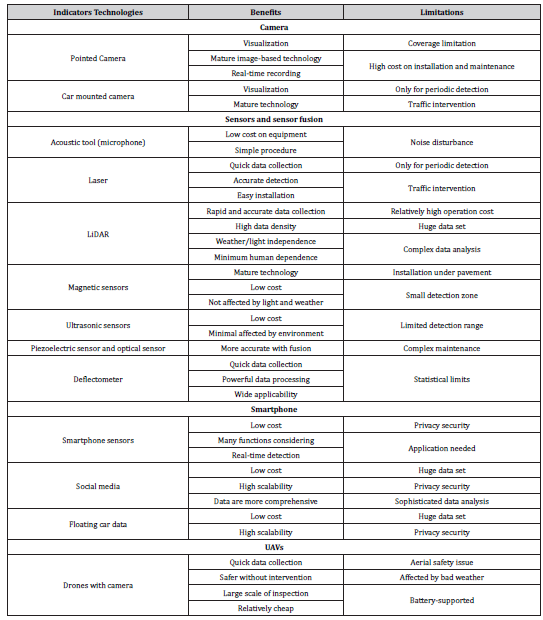
Compared with point sensors, there is a method to use vehiclemounted or drone-mounted to conduct a large scale of survey. The widely used sensors such as cameras, laser, lidar can be installed on vehicles or UAVs, which is an efficient method to address the issue of geographic restriction. Though the investigation of roadrelated data by using vehicle-mounted sensors may result in traffic flow intervention, it is also useful for management staff to obtain information regarding specific areas on a real time basis. UAVs equipped with sensors are a faster, more accessible and large-scaled device to collect data compared with traditional landbased methods, but the regulation of safety in aerial space and the weather effects are still the main issues in the application (Table 6).
Data analysis has become a focus as the data collected from many sources with different aspects, which needs cooperation with others from different academic background. Interdisciplinary collaboration is not a new concept. In order to study problems and processes of interdisciplinary inquiry, it is calling researchers to collaborate for better understanding of study [43]. For extracting useful information, machine learning and natural computation, such as neural networks, are introduced to filter irrelevant data and classify data into different groups based on the attributes of data. With respect to road related works, data including images, videos, signals and others are calling for a systematic analysis structure to identify the road context. Particularly, the continuous stimulation of social media in daily life leading to a new data source, which can be applied to intelligent traffic systems to predict the traffic condition, analyse accident zone, detect the behaviour of drivers and investigate the preference of drivers. An enormous database requires a mature data analysis framework to provide rapid and accurate outcomes to assist the assessment of roads and traffic.
Conclusion and Recommendations
From averaging the five simulation runs in VISSIM, the aggregated data used as MOVES inputs are shown in Table 4, and emissions results are shown in Table 5. Overall, PM peak hour CO2 emissions decreased by 6.8% across the whole corridor. Across the whole corridor, results show that between 1998 and 2012 total CO2 emissions decreased in the northbound direction for 2012 and increased for the southbound direction. The only exception to this was the 2.75-mile southbound segment with the third truck lane which showed a 7.4% decrease in emissions.
This review set out to address the two primary questions:
a. What is the evidence to support the use of existing data
collection methods for the road sector?
b. What is the evidence to support the state-of-the-art
technologies being used for road-related data collection and
analysis?
From the perspective of question (a), the existing (business as usual) data collection methods involve several aspects of traffic management and road asset management. There are various mature technologies used such as imagery technique, magnetic sensor, ultrasonic sensor, radar, acoustic sensors and laser. With regards to question (b), based on the data attributes and sources, the stateof- the-art technologies currently being proposed and used for road data collection and analysis are grouped into four parts: trafficrelated information, road condition analysis and maintenance, road safety and data from social media. The vehicle- mounted camera, a pair of magnetic sensors, LiDAR, smartphone, UAVs, acoustic sensor, ultrasonic sensor, laser, piezoelectric sensor and optical sensor are applied to data collection and analysis of road network. As the traffic condition is unstable, the road condition is complex and the databases composed by these tools are enormous, the data analysis method such as deep conventional network and neural network is used to extract useful information or used as an efficient classifier, which is a future application direction. However, strictly from the evidence of the review alone, it is not possible to suggest that these state-of-the-art technologies are all efficient with high quality operation, and it is hard to identify all kinds of technologies and different application because of the barrier of languages. There is no comparison among these technologies regarding the accuracy of data and the efficiency of collection. However, this review provides a comprehensive overview of the existing and emerging technologies and suggests a future research direction in road sector in the sensor fusion space and the combination of computer technology.
Acknowledgment
With great gratitude to my supervisor Dr Harry Evdorides for his guidance of the research, particularly in this special period of the pandemic, his support and encouragement motivated me to conduct comprehensive research. Besides, the continual guidance and comments provided by Mr Mostafa Massoud throughout the review were invaluable. In addition, I would like to thank my parents for their wise counsel and sympathetic ear, who supported me to continue my study in the United Kingdom. Finally, I could not have completed this dissertation without the support of my housemates, who provided happy distractions to help me strike the balance between study and entertainment during the city lockdown.
Conflict of Interest
No conflict of interest.
References
- Dabiri S, Heaslip K (2019) Developing a Twitter-based traffic event detection model using deep learning architectures. Expert systems with applications 118: 425-439.
- Cohn N (2019) The Tomtom Traffic Index: An Objective Measure of Urban Traffic Congestion.
- Robinson R (2008) Restructuring Road institutions, finance and management: volume 1: concepts and principles.
- Leduc G (2008) Road traffic data: Collection methods and applications. Working Papers on Energy, Transport and Climate Change 1(55): 1-55.
- Gough D, Oliver S, Thomas J (2017) An introduction to systematic reviews. Sage.
- com (2020) Technology Definition and Meaning | Collins English Dictionary. In: Dabiri S, Heaslip K (Ed.) Transport-domain applications of widely used data sources in the smart transportation: A survey. arXiv preprint arXiv:1803.10902.
- cambridge.org (2020) STATE-OF-THE-ART | Meaning in The Cambridge English Dictionary.
- Thomas J, Brunton J, Graziosi S (2010) EPPI-Reviewer 4: software for research synthesis. EPPI- Centre Software. London: Social Science Research Unit, UCL Institute of Education.
- Gough D (2007) Weight of evidence: a framework for the appraisal of the quality and relevance of evidence. Research papers in education 22(2): 213-228.
- Popay J, Roberts H, Sowden A, Petticrew M, Arai L, et al. (2006) Guidance on the conduct of narrative synthesis in systematic reviews. A product from the ESRC methods programme Version, p.b92.
- Ghosh A, Sabuj MS, Sonet HH, Shatabda S, Farid DM (2019) An Adaptive Video-based Vehicle Detection, Classification, Counting, and Speed-measurement System for Real-time Traffic Data Collection. In 2019 IEEE Region 10 Symposium (TENSYMP): 541-546.
- Namazi E, Holthe-Berg RN, Lofsberg CS, Li J (2019) November. Using Vehicle-Mounted Camera to Collect Information for Managing Mixed Traffic. In 2019 15th International Conference on Signal-Image Technology & Internet-Based Systems (SITIS), IEEE, pp. 222-230.
- Velisavljevic V, Cano E, Dyo V, Allen B (2016) Wireless magnetic sensor network for road traffic monitoring and vehicle classification. Transport and Telecommunication Journal 17(4): 274-288.
- Zhao J, Xu H, Liu H, Wu J, Zheng Y, et al. (2019) Detection and tracking of pedestrians and vehicles using roadside LiDAR sensors. Transportation research part C: emerging technologies 100: 68- 87.
- Ali HM, Alwan ZS (2017) Car accident detection and notification system using smartphone. Saarbrucken: LAP LAMBERT Academic Publishing.
- Tiedong W, Jingjing H (2014) December. Applying floating car data in traffic monitoring. In 2014 IEEE international conference on control science and systems engineering, IEEE, pp. 96-99.
- Axer S, Friedrich B (2014) Level of service estimation based on low-frequency floating car data. Transportation Research Procedia 3: 1051-1058.
- Gheorghiu RA, Stan VA, Iordache V, Buretea D, Costea IM (2019) Usage of Bluetooth scanners to detect urban traffic. In 2019 11th International Conference on Electronics, Computers and Artificial Intelligence (ECAI): 1-4.
- Elloumi M, Dhaou R, Escrig B, Idoudi H, Saidane LA (2018) Monitoring Road traffic with a UAV-based system. In 2018 IEEE Wireless Communications and Networking Conference (WCNC): 1-6.
- Khan NA, Jhanjhi NZ, Brohi SN, Usmani RSA, Nayyar A (2020) Smart traffic monitoring system using Unmanned Aerial Vehicles (UAVs). Computer Communications.
- Gwilliam K, Shalizi Z (1996) Sustainable transport: priorities for policy reform.
- Chambon S, Moliard JM (2011) Automatic Road Pavement Assessment with Image Processing: Review and Comparison. International Journal of Geophysics.
- Laurent J, Hébert JF, Lefebvre D, Savard Y (2012) Using 3D laser profiling sensors for the automated measurement of road surface conditions. In 7th RILEM international conference on cracking in pavements, Springer, Dordrecht pp:157-167.
- Xia W (2018) An approach for extracting road pavement disease from HD camera videos by deep convolutional networks. In 2018 International Conference on Audio, Language and Image Processing (ICALIP), IEEE,pp.418-422.
- Paje SE, Bueno M, Terán F, Viñuela U, Luong J (2008) Assessment of asphalt concrete acoustic performance in urban streets. The Journal of the Acoustical Society of America, 123(3): 1439-1445.
- Rosario F, Corte D, Giuseppe F, Giammaria F (2017) Sensing Road pavement health status through acoustic signals analysis. In 2017 13th Conference on Ph. D. Research in Microelectronics and Electronics (PRIME), IEEE, pp.165-168.
- Petitclerc B, Laurent J, Habel R (2018) Optimising 3D surface characteristics data collection by re- using the data for project level road design. Symposium on Pavement Surface Characteristics (SURF), Brisbane, Queensland. Australian Road Research Board.
- Li W, Burrow M, Metje N, Ghataora G (2020). Automatic Road Survey by Using Vehicle Mounted Laser for Road Asset Management. IEEE Access, 8: 94643-94653.
- Zhang D, Xu X, Lin H, Gui R, Cao M, et al. (2019) Automatic road-marking detection and measurement from laser-scanning 3D profile data. Automation in Construction 108: 102957.
- Lee J, Jan ZM, Verma B (2019) A Novel Neural Network Based Method for Analysis of Pavement Deflection Data. In 2019 IEEE Symposium Series on Computational Intelligence (SSCI), IEEE, pp. 2506- 2513.
- Singh G, Bansal D, Sofat S, Aggarwal N (2017) Smart patrolling: An efficient road surface monitoring using smartphone sensors and crowdsourcing. Pervasive and Mobile Computing 40: 71-88.
- Basavaraju A, Du J, Zhou F, Ji J (2019) A Machine Learning Approach to Road Surface Anomaly Assessment Using Smartphone Sensors. IEEE Sensors Journal, 20(5): 2635-2647.
- Pan Y, Zhang X, Cervone G, Yang L (2018) Detection of asphalt pavement potholes and cracks based on the unmanned aerial vehicle multispectral imagery. IEEE Journal of Selected Topics in Applied Earth Observations and Remote Sensing, 11(10): 3701-3712.
- Saad AM, Tahar KN (2019) Identification of rut and pothole by using multirotor unmanned aerial vehicle (UAV). Measurement 137: 647-654.
- Aliyu A, Kolo JG, Mikail OO, Agajo J, Umar B, et al. (2017) November. An ultrasonic sensor distance induced automatic braking automobile collision avoidance system. In 2017 IEEE 3rd International Conference on Electro-Technology for National Development (NIGERCON) (pp. 570-576).
- Wu J, Xu H, Zhang Y, Sun R (2020) An improved vehicle-pedestrian near-crash identification method with a roadside LiDAR sensor. Journal of Safety Research.
- Pan B, Zheng Y, Wilkie D, Shahabi C (2013) November. Crowd sensing of traffic anomalies based on human mobility and social media. In Proceedings of the 21st ACM SIGSPATIAL international conference on advances in geographic information systems, pp.344-353.
- D'Andrea E, Ducange P, Lazzerini B, Marcelloni F (2015) Real-time detection of traffic from twitter stream analysis. IEEE transactions on intelligent transportation systems 16(4): 2269-2283.
- Maghrebi M, Abbasi A, Waller ST (2016) November. Transportation application of social media: Travel mode extraction. In 2016 IEEE 19th International Conference on Intelligent Transportation Systems (ITSC), IEEE, pp.1648-1653.
- Alomari E, Mehmood R, Katib I (2019) Road traffic event detection using twitter data, machine learning, and apache spark. In 2019 IEEE SmartWorld, Ubiquitous Intelligence & Computing, Advanced & Trusted Computing, Scalable Computing & Communications, Cloud & Big Data Computing, Internet of People and Smart City Innovation, IEEE: 1888-1895.
- Mounica B, Lavanya K (2020) Social Media Data Analysis for Intelligent Transportation Systems. In 2020 International Conference on Emerging Trends in Information Technology and Engineering (ic-ETITE), IEEE, pp.1-8.
- Rashidi TH, Abbasi A, Maghrebi M, Hasan S, Waller TS (2017) Exploring the capacity of social media data for modelling travel behaviour: Opportunities and challenges. Transportation Research Part C: Emerging Technologies, 75: 197-211.
- Derry SJ, Schunn CD, Gernsbacher MA (2014) Interdisciplinary collaboration: An emerging cognitive science. Psychology Press.
- Asvadi A, Garrote L, Premebida C, Peixoto P, Nunes UJ (2018) Multimodal vehicle detection: fusing 3D-LIDAR and color camera data. Pattern Recognition Letters, 115: 20-29.
- Gui K, Ye L, Ge J, Cheikh FA, Huang L (2019) Road surface condition detection utilizing resonance frequency and optical technologies. Sensors and Actuators A: Physical, 297: 111540.
- Haoui A, Kavaler R, Varaiya P (2008) Wireless magnetic sensors for traffic surveillance. Transportation Research Part C: Emerging Technologies, 16(3): 294-306
- Inzerillo L, Di Mino G, Roberts R (2018) Image-based 3D reconstruction using traditional and UAV datasets for analysis of road pavement distress. Automation in Construction 96: 457-469.
- Jenelius E, Petersen T, Mattsson LG (2006) Importance and exposure in road network vulnerability analysis. Transportation Research Part A: Policy and Practice 40(7): 537-560.
- Pring R, Thomas G (2004) Evidence-based practice in education. McGraw-Hill Education (UK).
- Thomas J, McNaught J, Ananiadou S (2011) Applications of text mining within systematic reviews. Research Synthesis Methods 2(1): 1-14.
-
Bosong Jiao, Harry Evdorides and Mostafa Massoud. A Systematic Review of Existing Methods plus the State-of-the-art Technologies Used to Collect Road-Related Data and its Usage. Cur Trends Civil & Struct Eng. 8(4): 2022. CTCSE.MS.ID.000692. DOI: 10.33552/CTCSE.2022.08.000692.
-
Road data collection; State-of-the-art technologies; Traffic; Road maintenance; Road safety
-

This work is licensed under a Creative Commons Attribution-NonCommercial 4.0 International License.


