 Research Article
Bathymetric Characteristics of Lake Malombe, Malawi
Msiska OV1*, Chigona G2, Banda J3 and Bulirani A4
1Fisheries Consultant, Mzuzu, Malawi
2Hydrographic Unit, Monkey Bay, Malawi
3Fisheries Research Institute, Monkey Bay, Malawi
4Ministry of Agriculture, Irrigation and Water Development, Lilongwe 3, Malawi
Joe N Lucas, Chromotrax, Inc., 9 Lychee Court, San Ramon, CA, USA.
Received Date: August 06, 2021; Published Date: September 21, 2021
Abstract
The Lake Malombe floor was subjected to a bathymetric study to determine the physical features that have been influenced by periodic desiccation and refilling during evolution of the lake. This lake fish resources have undergone major declines in catches from a maximum of 12, 000 to 3, 000 tons between 1976-2016, creating adverse effects on livelihoods of communities. This prompted a number of scientific studies, of which this is only one. The cross-section of the lake floor was found to be composed of a steep slope on the eastern side, a trough and ridge in the middle followed by a gentle zone in the west. The southern portion is shallow and muddy. Distribution and concentration of biological organisms are influenced by the nature of the bottom such that the mud-water interface is critical to zoobenthos colonization. The lake was computed to cover 31,020 ha with a maximum depth of 5.6m; indicating shallowing from 7m in 1993 and 17m in 1950s. Thus, a further possibility of drying are speculated if the trend continues; this could adversely affect energy and irrigation developments downstream. Therefore, the regulatory barrage installed downstream on the Middle Shire should be replicated by similar control between Lake Malawi and Upper Shire, otherwise as the lake shows signs of shallowing it could threaten sustainability of any projects downstream. Regarding regeneration of fish resources, attention should also be given to benthic browsers and low oxygen tolerant species because of the rich anaerobic zoobenthos.
Introduction
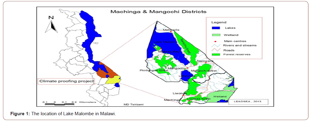
Lake Malombe situated between 14o30’-14o45’S and 35o12’- 35o20E’, is an impoundment of the outflow from Lake Malawi via the Upper Shire river (Figure 1). The lake is 30km long and about 15km wide. As of 2017, the lake covered a total surface area of 314 Km2 while maximum and mean depths were estimated at 4.3 m and 3.0±0.95 m, respectively [1].
The fisheries of the lake are multi-species and multi-gear in nature commenced on a commercial scale in the 1960s after the eradication of a large crocodile population [2]. Currently, over 3,964 fishers consisting of 12% Gear owners and 88% Crew members are directly employed in the fishery. Although fisheries are impacted by fishing and the physico-chemical parameters, the bathymetric factors are usually little understood. Only Eccles [3] reported on bathymetric factors of Lake Malawi and was first to report on warming effect in the deep zones, which has now been accentuated by climate change [4].
The FAO Project entitled “Increasing resilience to climate change in the fishery sector of southern Lake Malawi and Lake Malombe” (TCP/MLW/3504) was designed to collect baseline data on Lake Malombe to determine physical, biological and chemical factors influencing the behaviour of Lake Malombe. While past studies concentrated on fisheries activities [5-7], physical factors influencing the hydrographic dynamics, benthic and limnology aspects were generally neglected. For more than 10 years, a fisheries co-management system was implemented on Lake Malombe, however, its success is being debated and had no visible impact as fish catches continue to decline [6]. Downstream, the ecosystem around the Shire Barrage has been monitored for environmental impact [8].
Dulanya et al, [9] undertook core sampling of Lake Malombe and provided evidence of complete desiccation within the past 100 years and acceleration of eutrophication; this evidenced from deposits of diatoms and invertebrates being the main proxies. Generally, there is a dearth of knowledge about many aspects of the lake despite being a significant contributor to fish catches which at the peak reached about 12,000 tons. The Lake’s impact on downstream investments with regard to energy generation and irrigation are scarcely mentioned in an EIAS study conducted [8]. It is noteworthy that Malawi depends on Shire River for almost 100% of its electricity generation and large irrigation projects are operating downstream and others other water-demanding activities are operational in the same area. Although the impacts of man-induced and climate changes have lacked comprehensive studies, it is speculated that fisheries are already adversely their combined effects. A related study has shown that the benthic portion of the lake is rich in invertebrates and bacteria [10], indicating that productivity in surface waters benefits from the benthic zone. Meanwhile, little is known about the structure of the lake floor, its dynamics and how this is impacted by the surrounding environment. Lewis, [11] has postulated that coupling of the benthic and overlaying waters is usually compounded by the shallowness of the ecosystem and anthropogenic activities. The sediment-water exchange is affected by the roughness of the sediment and the surface area thereby accelerating mass and nutrient transfer [12]. Detailed observations of the benthos indicate that invertebrates and bacteria far exceeded those of Lake Malawi and Upper Shire [10]. This is evidence that the lake floor is critical to the functioning of the lake.
Objectives of the study were:
1) To map the bathymetry of the floor area of Lake Malombe,
2) To determine basic morphometric features,
3) Provide benchmark for benthic studies, and
4) To inform policy experts regarding in situ and on downstream developments.
Methodology
The study was conducted in Lake Malombe, which lies between Lake Malawi and Shire River in southern part of Malawi, at latitude 14021’ to 14045’south and longitude 35010’ to 35020’ east covering an approximate area of 390 km2. The study was conducted after the rains in May and October 2017.
Bathymetry studies
The survey reference and control points were established using RTK GPS (Base GPS GX 1230 GG 466887; Rover GPS GX 1230 GX466968). Two survey controls (BMA and BMB) were thus fixed near the lake. The rest of the survey was then conducted from Mangochi (MARM 13) to Mwalija Fishing Camp at Chawla (Figure 2).
Soundings
Data present measurements based on the distance between the surface of the water and the top of the water-sediment interface. Due to water fluctuations, a reference point was established at Mwalija. The datum was recorded at 5.27m as the lowest water level at a height of 474.43m above sea level. Water levels were collected in the morning and afternoon each day. To smooth-out for fluctuations due to tides, each value calculated was subtracted from 5.27m (Figure 3).
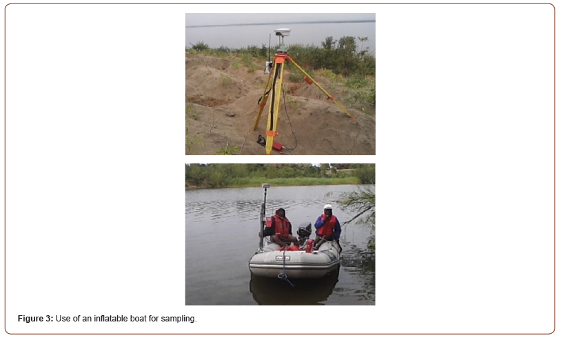
The equipment used to collect these data involved a raft, boat, an eco-sounder and RTK GPS. The Echosounder was mounted directly below the GPS antenna alongside the survey boat. The Echo sounder were calibrated as shown in Table 1. Profile lines perpendicular to the lake channel were established for bathymetric survey spaced at 150m apart and extended along the entire shoreline. For quality check, the line running perpendicular to the profile lines from the Centre of the lake was surveyed as illustrated in Figure 1. The RTK base was over the survey control and Rover was mounted on the boat, meanwhile fixes were made on Echo Sounder and Rover Controller, at 5 m interval. The bar check and draft of the boat were conducted at the beginning and at the end of the survey to obtain a sound velocity profile used in sound reduction (Figure 4).
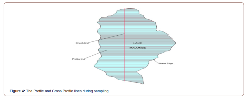
Table 1:Macro-fauna of Lake Malombe.

Data processing
Horizontal positions obtained in the field were imported onto an Excel spread sheet and merged with soundings. After positioning corresponding horizontal soundings against fixes, the file was imported into the Hypack Max Software. This Software was used to clean the data which data which was then transformed into an XYZ format for export to SURFER and Arc View Software thereby generating ASCII XYZ file.
Use of Arc view software
This program was used to create contours by the Inverse Distance Weighted Interpolator. This was considered to be better than the Spine Interpolator for small data sets as its weights points close to the processing cell. The Rivers and other data were added to the contour map from digitized from the 1:50, 000 scale.
Use of SURFER software
This computer program was used to generate 3D model for the floor, and the same was used to calculate the volume of the lake. The Garmin Etrex 10 GPS device was used to locate and record sampling points.
Benthic sample collection
The lacustrine zoobenthos were sampled using an Ekman Birge grab in May and October 2017 by collected soil samples from the bottom of the lake. These samples were preserved in 70% ethanol to reduce postmortem degeneration. Organisms were sorted using a magnifying glass and a dissection microscope to their lowest taxa; large organisms were placed in a tray while the smaller ones used petri dishes. The type and quantity of organisms were matched with soil types.
Microbiological analysis of benthos
Soil samples collected by the Ekman Birge grab were also subjected to total viable counts, aerobic, anaerobic and fungi after culture and incubation for 18 hours using nutrient agar prepared from 28g nutrient agar, 15.5 g of malt extra agar and 15.5gof nutrient broth. These were placed into conical flasks to which 1 liter of ionized water was added. The media had been autoclaved for 15 min at 1210C and later cooled down. Culture plates were prepared on sterile petri dishes in duplicates. Dilutions of 0.1ml were made using a micropipette and transferred aseptically into pre-prepared agar plates by raising the upper lid enough to enter the tips of the pipette. Samples were spread homogenously and aseptically arranged by sterile flamed L-shaped glass rod throughout the entire surface of the media until the sample dried out according standard methods [13].
Nutrient broth media was placed in a Bio-Bag system where there was an air-tight bag containing petri dishes and was sealed. A disposable hydrogen gas container was allowed to react with oxygen to form water in a sealed bag until all the oxygen was consumed, thereby creating an anaerobic environment. Thereafter, autoclaving was done to remove dissolved oxygen. The shake culture technique was applied and a tube of Fluid Thioglycolate (FTG) medium held at 48 ∘C was inoculated before solidifying. A small portion of the agar remained to increase viscosity and reduce oxygen diffusion into the medium. An indicator was turned colorless in the absence of oxygen was included to confirm that anaerobic conditions were indeed achieved.
Soil samples of 1g were transferred into vial containing 9 ml sterile peptone water. This was shaken for 10ml and made to stand for 20 min, thereafter, 6-fold serial dilutions were carried out in triplicates. After incubation at 280 ∘C Total Viable counts were for bacteria. Colony-forming units (CFU/g) were counted under a Quebec dark field colony counter (Leica, Buffalo, NY, USA) that is equipped with a guide plate ruled in square meters.
Results and discussion
Bathymetric features
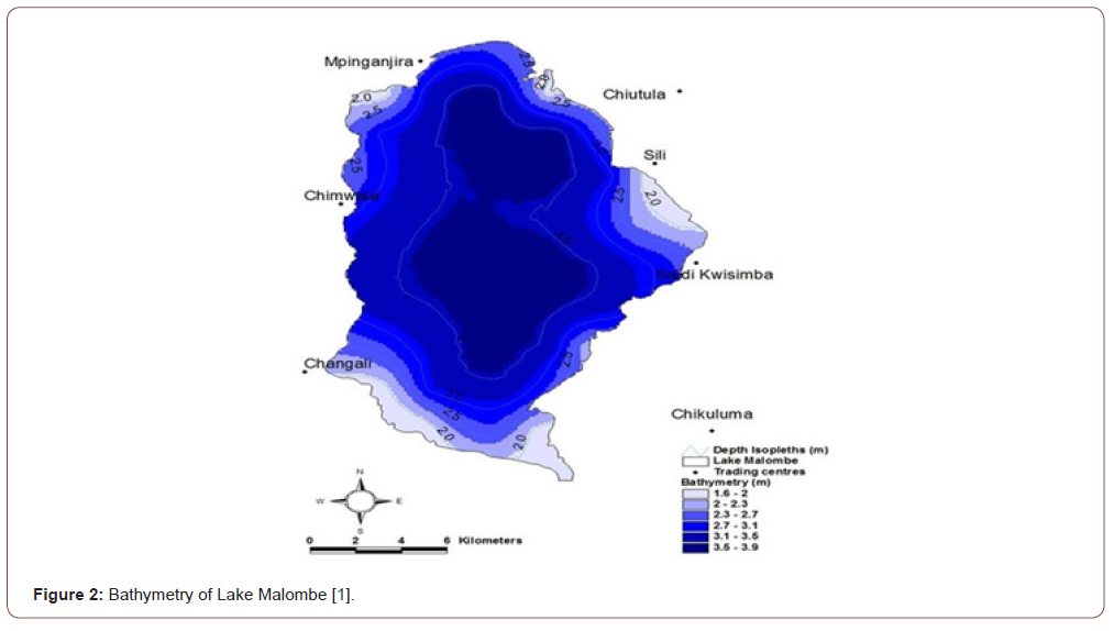
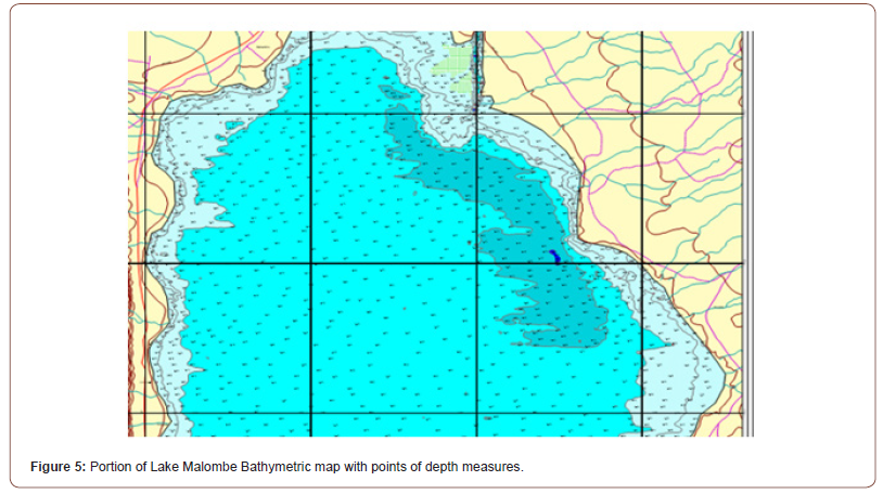
A bathymetry map that was obtained is shown in Figure 3 showing points of depth measurements. Lake Malombe had the following features;
i. A surface area of approximately 31,020 ha;
ii. Perimeter of 84,000 m;
iii. Volume is 1,013,413, 011 m3 ;
iv. The deepest part of the lake is 5.6 m and most of the area lies between 3 and 4 m; and there is a channel on the eastern side where Shire river passes.
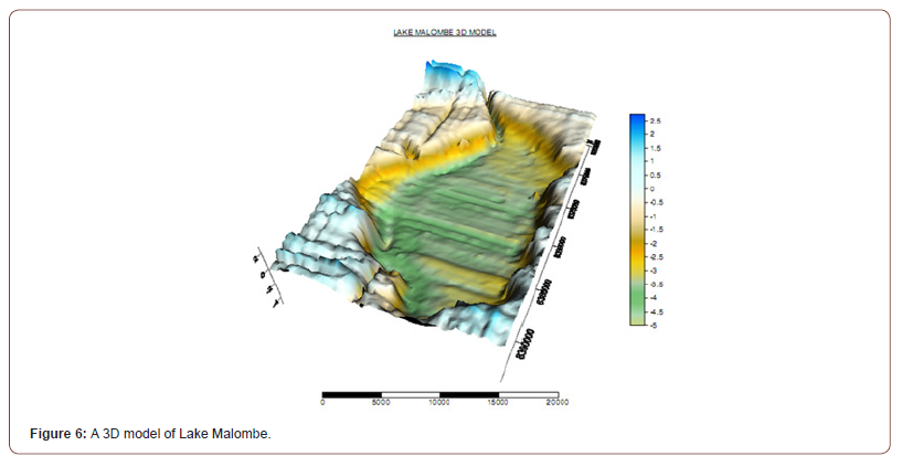
The cross-section of Lake Malombe can also be viewed in the 3D model shown in Figure 6.
In the northern part of the lake, there is a steep slope in the west decreasing to a gentle slope in the middle-followed ending with a gentle slope in the east (Figures 5-7).

The middle part starts with a steep slope in the west decreasing and has a gentle slope in the middle up to the deepest point. There is a ridge, a trough and a gentle slope in the middle ending with a steep slope in the east (Figure 8).

The southern portion decreases with gentle slope in the middle up to the deepest point, where the river passes. Thereafter, there is a steep slope to the east (Figure 9). The depth difference between east and west of the lake indicates high sedimentation due to intensive agricultural activities in the catchment in the latter section of the lake (see Figure 9).

The middle portion starts with a steep slope up to deepest point followed by a gentle slope, a ridge, trough and another steep slope on eastern side. Meanwhile, the southern portion of the lake is also the mouth of the Middle Shire; it is shallower and muddy compared to the middle and northern portion, suggesting that deposition of sediment takes place there as shown in Figure 5. Figure 6 shows a shallow portion due to mud sediments that are colonized on the fringes by shrubs which effectively have reduced the size of the lake on that part. The concentration of biological organisms including fish, snails, bacteria and other invertebrates follows certain patterns related to the dynamics at the sediment-water interface [4,10,14] (Figure 10).

This study has high-lighted the necessity of high-resolution mapping for a better profiling of the lake floor with regard to its geological evolution and other lake processes. Given the large numbers of projects in energy and irrigation invested downstream, this study is useful beyond fisheries productivity and management. The major challenge is to maintain adequate water flow from Lake Malawi to Upper Shire to sustain allied projects in the face of climate change and high sediment inflow from human activities in the lake environs? This is evident from the change in lake water levels from 7 m in to 5.6 m. While using the Barrage to control water flow in the middle Shire suffices to control downstream volumes the Upper Shire is need to be considered for similar control to ensure sustainability.
Benthic Invertebrates distribution in Lake Malombe.
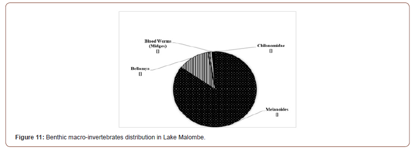
Figure 11 shows distribution of invertebrates in the benthic portion of the lake.
The Bellamya capillata was found to contribute 12% while chironomids larvae contributed only 1%. Thus, Lake Malombe shows great disparities of benthic fauna distribution and abundance.
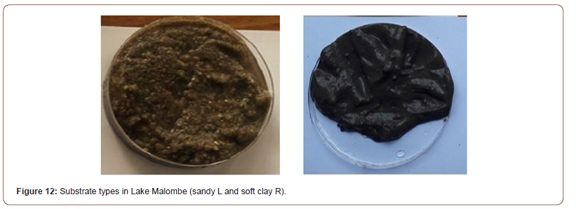
Results from 35 sampling station in Lake Malombe revealed that snails dominated the zoobenthic invertebrates followed by Diptera larvae, annelids, and black fly larvae. The Melanoides were more abundant in the north-western part of the lake. Most invertebrates including tubifex, water beetles and chironomids larvae, were especially present at water depths of between 2.5m and 3.5m. The latter invertebrates were mostly found in muddy bottom substrates. Although not fully quantified there was correlation between bottom type and organism affinity. The high occurrence of anaerobic bacteria is evidence of lack of oxygen at the sedimentwater interface and hence abundance invertebrates.
Most importantly, maximum depth seems to have been reduced from 7 meters in1993 to 5.6 meters of current; this alone could have serious implications on the evolution of the lake and downstream operations. Further studies are required to investigate if a dryingout phase is in the offing (Figure 12).
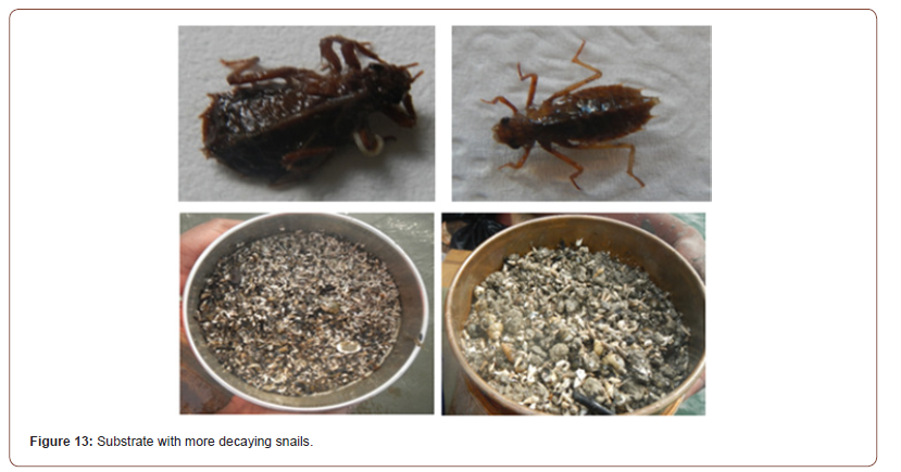
There was higher accumulation of rotting and larger pieces decaying animal material (Figure 13).
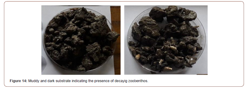
Annelids were more common in substrates with more detritus and debris than other substrates with dead decaying snail shells. Tubifex and blood worms (midges) were more common in substrates with dead decaying snail shells (Figure 14).
Association of bacteria and fungi with substrates
Not only were bacteria associated with specific mud characteristics, the quantities of anaerobic and fungi were much higher than aerobic bacteria, indicating potential for a niche for fish and other organisms that browse at the mud-water interface and are tolerant of low oxygen water regimes.
Table 2:The bacteria groups found on different substrates.

Acknowledgement
The authors wish to thank the former FAO Representative to Malawi, Ms. Florence Rolle, Lilongwe, Malawi and The Director of Malawi Fisheries Department who facilitated this study through a Project (TCP/MLW/3504) “Increasing resilience to Climate Change in the fishery sector of southern Lake Malawi and Lake Malombe”. Support for the study was obtained from the FAO Office (Mr. Vasco) in Harare, Zimbabwe and Dr. Simon Fudge-Smith, FAO, Rome, Italy.
Conflict of interest
None.
References
- Msiska OV, GD Kanyerere, S Ngwira, M Manda (2017) A prognosis of the causes of vulnerability of Lake Malawi fish resources in Karonga town. International Journal of Fisheries and Aquaculture 9(6): 59-72.
- Tweddle D (1994) Twenty years of fisheries research in Malawi: a brief review of Malawi Government Fisheries Department Research Programmes conducted since 1970. Fisheries Bulletin No. 7. Fisheries Department , Ministry of Forestry and Natural Resources, Lilongwe: 43.
- Eccles DH (1974) An outline of the physical limnology of Lake Malawi (Lake Nyasa). Limnology and Oceanography 19: 730-742.
- Msiska OV, GZ Kanyerere, S M’balaka, A Nkhoma, A Chimera, et al. (2019) Relative Abundance and Species Composition of Fish Stocks of Lake Malombe, Malawi. European Journal of Agriculture and Food Sciences.
- Weyl OLF, Mandere DS, Mwakiyongo KR (2010) An assessment of the nkacha net fishery of Lake Malombe, Malawi. African Journal of Aquatic Science 1(1): 47-55.
- Hara M, F Njaya (2016). Between a rock and a hard place: The need for and challenges to implementation of Rights Based Fisheries Management in small-scale fisheries of southern Lake Malawi. Fisheries Research 174: 10-18.
- Zwieten van PAM, Banda Moses C, Kolding J (2011). Selecting indicators to Assess the Fisheries of Lake Malawi and Lake Malombe: Knowledge Base and Evaluation Capacity. Journal of Great Lakes Research 37: 26-44.
- SMEC (2013). Final Environmental and Social Impact Assessment, Vol.2: Technical Reports: Independent Environmental Impact Assessment for the Upgraded Kamuzu Barrage. Water Development Programme. Ministry of Water development and Irrigation. Government of the Republic of Malawi.
- Dulanya Z, I Croudace, JM Reed, MH Trauth (2014) Palaeolimonlogy and reconstruction of recent environmental change in Lake Malombe (S. Malawi) using multiple proxies. Water SA 40(4): 717-728.
- Kamtambe K, J Banda, B Kaphuka, OV Msiska( 2019) The Abundance, Distribution and Diversity of benthic invertebrates of Lake Malombe. Journal of Fisheries and Aquaculture 11(2): 13-22.
- Lewis WM (2009) Lake Ecosystems: Structure, Function and Change, In GE Likens (Editor) Lake Ecosystem Ecology. Encyclopedia of Inland Waters. Elsevier Inc: 1-40.
- Lorke A, S Macintyre (2009) The Benthic Boundary (in Rivers, Lakes and Reservoirs), In GE Likens (Editor) Lake Ecosystem Ecology. Encyclopedia of Inland Waters. Elsevier Inc: 115-123.
- APHA (2017) Standard Methods for the Examination of Water and Wastewater. Rice, EW., RB, Baird, AD, Eaton, Editors. American Public Health, Water Works Association and Water Environment Federation, 23rd Edition. AWWA Headquarters, Denver, CO, USA.
- Msiska OV, Kanyerere GZ, M’Balaka S, Phiri E, Chimera A, et al. (2020) The Fish Catch Composition, Size Distribution and Selectivity of Fishing Gears Used on Lake Malombe, Malawi. Journal of Environmental Science and Allied Research 1(1).
-
Msiska OV, Chigona G2, Banda J, Bulirani A. Bathymetric Characteristics of Lake Malombe, Malawi. Ad Oceanogr & Marine Biol. 2(5): 2021. AOMB.MS.ID.000550.
-
Lake Malombe, Bathymetric study, Bellamya capillata , Melanoides, Hypack Max Software
-

This work is licensed under a Creative Commons Attribution-NonCommercial 4.0 International License.


