



 Research Article
Sources and Impacts of Drinking Water Contamination in Coastal Akwa Ibom State: Integrating Community Perception with Field-Based Evidence
Received Date: August 13, 2026; Published Date: August 27, 2026
Abstract
Access to safe drinking water remains a major environmental and public health challenge in coastal regions where hydrogeological vulnerability intersects with anthropogenic activities. This study examined the sources and impacts of drinking water contamination in coastal Akwa Ibom State, Nigeria, by integrating community perception with field-based hydrochemical evidence. A mixed-method approach involving household surveys, interviews, direct field observations, and laboratory analysis of groundwater samples was adopted across selected communities in Mbo, Ibeno, Esit Eket, Eastern Obolo, and Ini Local Government Areas. A total of 314 questionnaires were administered, while groundwater samples collected during wet and dry seasons were analyzed for physicochemical, microbial, and heavy metal parameters using World Health Organization standards. Findings revealed elevated turbidity, electrical conductivity, total dissolved solids, iron, arsenic, chromium, and microbial contamination in several boreholes, particularly during the wet season. Community responses identified industrial activities, seawater intrusion, poor sanitation, aging boreholes, and inadequate waste management as major contamination drivers. Residents also reported unpleasant taste, odour, discoloration, and increased incidence of waterborne diseases. The study concludes that coastal groundwater systems in Akwa Ibom State are increasingly vulnerable to both natural and human-induced contamination, requiring integrated groundwater monitoring, improved sanitation infrastructure, and communitybased water management interventions.
Keywords: Drinking water contamination; Coastal groundwater; Community perception; Seawater intrusion; Akwa Ibom State
Introduction
Access to safe drinking water remains a fundamental public health requirement, yet it is increasingly threatened in many coastal environments due to the combined effects of natural hydrogeological processes and intensified human activities. Globally, groundwater serves as a major source of drinking water for approximately onethird of the world’s population, particularly in coastal regions where surface water may be scarce or polluted (Nickson et al., 2005) [1]. However, coastal aquifers are highly vulnerable systems because of their proximity to seawater, shallow groundwater tables, and increasing anthropogenic pressures such as urbanization, agriculture, and oil-related activities (Foster, 1998; Chidambaram et al., 2008) [2,3]. In Nigeria, coastal aquifers are critical sources of domestic water supply, especially in the Niger Delta region where piped water infrastructure is limited. Studies across coastal Nigeria consistently report deteriorating groundwater quality linked to salinization, microbial contamination, and geogenic-metal enrichment (Edet, 2016; Antai et al., 2023) [4,5]. In Akwa Ibom State specifically, groundwater in coastal plain sands is widely used for drinking and domestic purposes, yet it is increasingly affected by seawater intrusion and contamination from both natural and human-induced sources. Recent hydrochemical investigations have shown that groundwater in several coastal communities is acidic and saline, with elevated chloride, turbidity, and microbial loads exceeding World Health Organization (WHO) guidelines in some locations.
The major sources of drinking water contamination in coastal Akwa Ibom State can be grouped into three interrelated categories. First, geogenic processes, particularly seawater intrusion, occur when over-abstraction or low hydraulic gradients allow saline water to migrate into freshwater aquifers. This is a well-documented phenomenon in coastal aquifers globally and is especially pronounced in low-lying deltaic environments (Chidambaram et al., 2008) [3]. Second, anthropogenic activities such as improper waste disposal, agricultural runoff, oil exploration, and poorly constructed boreholes introduce nitrates, heavy metals, and pathogenic organisms into groundwater systems. Third, climatic and hydrological variability, including flooding and rising sea levels, enhances pollutant transport and accelerates aquifer contamination processes. Empirical studies in Akwa Ibom State confirm these patterns. For instance, groundwater assessments in coastal LGAs reveal bacterial contamination and the presence of heavy metals in borehole water, raising concerns about public health risks for dependent communities. Similarly, physico-chemical analyses indicate spatial variability in groundwater quality, with several locations exhibiting salinity levels and turbidity beyond acceptable drinking water standards. These findings suggest that contamination is not uniform but varies according to proximity to the coastline, land use activities, and aquifer vulnerability.
Beyond field measurements, community perception studies provide an important complementary perspective. Residents in coastal communities often report noticeable changes in water taste (salinity), color, and odor, as well as increased incidence of waterborne diseases. Such perceptions frequently reflect underlying hydrochemical realities, but they also influence wateruse behavior, including reliance on untreated borehole water or alternative unsafe sources. Integrating these perceptions with laboratory-based evidence is essential for a holistic understanding of drinking water challenges and for designing locally appropriate water management strategies. In a broader global context, similar challenges have been documented in coastal aquifers in India, Bangladesh, and parts of Southeast Asia, where seawater intrusion and pollution from human activities have rendered groundwater unsafe for consumption. These comparative cases highlight that coastal aquifer contamination is a transboundary environmental issue requiring integrated hydrogeological monitoring and community-based management approaches.
Therefore, this study on sources and impacts of drinking water contamination in coastal Akwa Ibom State adopts an integrated approach that combines field-based hydrochemical evidence with community perception data. This is essential for identifying contamination pathways, understanding lived experiences of water insecurity, and informing sustainable groundwater management policies in coastal environments. The research objectives were; to identify and characterize the major sources of drinking water contamination in coastal communities of Akwa Ibom State, including both natural (e.g., seawater intrusion) and anthropogenic (e.g., waste disposal, oil-related activities) factors, to examine community perceptions of drinking water contamination, including observed changes in taste, color, odor, and associated health effects, to observe and document visible environmental and infrastructural sources of drinking water contamination in selected coastal communities of Akwa Ibom State, such as proximity to waste dumps, drainage conditions, oil-related activities, and borehole siting practices etc and to assess the relationship between observed environmental conditions and community-reported experiences of drinking water contamination, using data obtained from questionnaires and interviews
Literature Review
Identifying sources of groundwater contamination and understanding the mechanisms governing groundwater quality are essential prerequisites for effective management and protection of this critical resource. Sustainable groundwater utilization depends on a clear understanding of the complex hydrogeological and environmental processes that influence water quality, particularly in vulnerable coastal systems (Venkatesh et al., 2021). In coastal environments, groundwater quality dynamics are shaped by interacting natural and anthropogenic factors, requiring comprehensive assessment for long-term resource sustainability. Contaminated groundwater remains a major public health concern globally, as it serves as a primary pathway for waterborne diseases such as Hepatitis E, typhoid fever, acute diarrhea, and rotavirus infections (Muhammad et al., 2011; Ormachea et al., 2013; Lu et al., 2015; Nkpaa et al., 2018; Singh et al., 2018) [6-8]. Contamination sources may be natural or human-induced. Naturally, groundwater may be contaminated through fractured rock systems, where irregular fracture networks facilitate pollutant movement in unpredictable pathways that complicate detection and control (Karthikeyan et al., 2022) [9].
Anthropogenic sources significantly amplify groundwater contamination risks. Some wells draw water from nearby surface water bodies such as rivers and lakes, while artificial recharge systems may introduce contaminants from stormwater, irrigation return flows, industrial effluents, or treated sewage. Additionally, pumping activities can induce infiltration from improperly sited or poorly maintained septic systems, allowing pathogens and chemicals to enter aquifers. Topography plays a crucial role in groundwater recharge, flow, and salinity distribution, particularly in coastal areas (Abraham et al., 2024). Coastal geomorphological features such as sand dunes, barrier systems, and karst formations influence aquifer storage and flow dynamics. Climate changeinduced sea level rise further increases flooding risks in low-lying coastal communities, intensifying groundwater contamination vulnerability. Studies in flood-prone terrains confirm that coastal flooding is a major contributor to drinking water contamination. Vimalathithan (2016) [10] assessed groundwater quality in such environments using parameters including pH, EC, TDS, hardness, alkalinity, and major ions. Results showed that groundwater quality is controlled by geological formations, meteorological conditions, and human activities. The study confirmed that domestic activities and local environmental conditions significantly influence groundwater suitability for consumption.
Geological variability is another critical determinant of groundwater sustainability. Coastal aquifers are often composed of volcanic, limestone, or sedimentary formations, which influence groundwater flow and seawater interaction processes (Zamrsky et al., 2020) [11]. Submarine groundwater discharge, affected by geological structure, can transport nutrients, pollutants, and heat into coastal waters, altering geochemical cycles. Most coastal aquifers globally are sedimentary, shallow, and unconfined due to continuous deposition from rivers, wind, and marine processes (Lesser et al., 2018) [12]. Aquifer geometry also plays an important role in seawater intrusion dynamics. Convergent aquifers tend to limit seawater intrusion, while divergent aquifers are more vulnerable, with lower water table elevations (Luo et al., 2021; Hanif et al., 2020) [13,14]. Similarly, aquifer permeability and storage capacity regulate groundwater movement and contamination susceptibility. High permeability enhances contaminant migration, while storage characteristics influence pressure propagation within the aquifer system (Oberle et al., 2017). Empirical studies support these findings. Laluraj et al. (2005) [15] reported severe degradation of coastal aquifers in Kerala, India, due to anthropogenic activities. High sodium and chloride levels indicated seawater intrusion, while microbial contamination posed health risks. Similarly, Emuobonuvie et al. (2024) [16] assessed groundwater quality in coastal Ghana, reporting acidic pH levels, elevated electrical conductivity, and contamination by nitrate, arsenic, and iron. Water Quality Index results indicated marginal to poor water quality, with significant health risks from heavy metals.
Comparable studies in Kenya by Mwakio (1997) [17] showed that shallow boreholes in coastal Kwale were highly susceptible to contamination from septic systems and seawater intrusion, with E. coli detected in several water sources. Over-pumping exacerbated saltwater encroachment, with seawater intrusion advancing inland. Similarly, Abd-Elhamid et al. (2019) and Li et al. (2019) [18] confirmed that rising sea levels and groundwater extraction significantly accelerate saltwater intrusion into coastal aquifers. Globally, seawater intrusion has been documented in Asia, Africa, Europe, and the Americas. In India, coastal aquifers in Tamil Nadu and Rameshwaram have experienced intrusion extending up to 2 km inland due to excessive groundwater abstraction. Bangladesh’s Ganga Delta and Vietnam’s Mekong Delta are highly vulnerable due to low elevation and storm surges, while Indonesia and South Korea also face increasing salinization pressures (Wahyono et al., 2022) [19]. Similar challenges are reported in Spain, Italy, the USA (Florida, California, Louisiana), and the Middle East. In Nigeria, coastal groundwater contamination is strongly linked to geological and anthropogenic processes (Abraham et al, 2022, 2025, Ekpeyong et al, 2025; Jimmy et al, 2025, 2026). Adebo and Adetoyinbo (2009) [20] identified chloride exceedance in Lagos coastal aquifers due to seawater intrusion. Ajibade et al. (2010) [21] reported heavy metal contamination in Ibadan groundwater, while Nwankwoala and Udom (2011) [22] linked high chloride levels in the Niger Delta to saltwater intrusion. Essang et al. (2024) [23] further identified heavy metal contamination in Mbo LGA, Akwa Ibom State, particularly lead, iron, and nickel exceeding WHO limits, largely attributed to oil exploration and urban activities.
Agricultural contamination is also significant. Brindha and Kasinatha (2011) [24] reported nitrate pollution in Chennai coastal aquifers, with concentrations up to 106 mg/L due to fertilizer use and septic leakage. Pesticide contamination is widespread globally, particularly in tropical agricultural systems. Studies in Bangladesh, Thailand, and the Philippines revealed persistent organochlorine and organophosphate residues in groundwater, with concentrations exceeding safe limits in several cases (Hudak and Thapinta, 2005; Navarrete et al., 2018; Abubakar and Ali, 2021) [25,26]. Industrialization further exacerbates groundwater contamination. Lang et al. (2015) [27] reported hydrocarbon and heavy metal pollution in industrial coastal zones of Algeria, China, and India. Similar patterns were observed in Brazil, where urbanization and petroleum activities increased groundwater vulnerability (Publio et al., 2023) [28]. Key contamination drivers include soil permeability, water table depth, and effluent discharge practices. Sanitation systems are another major source of groundwater pollution, especially in densely populated coastal and island environments. Peter (1997) [29] demonstrated that septic tanks and latrines significantly contribute to nitrate and microbial contamination in tropical islands. Studies across the Caribbean, Pacific islands, and the United States confirmed widespread faecal contamination of groundwater sources, often forcing closure of drinking water wells.
Population growth and urban expansion further intensify groundwater stress. Over-extraction for agriculture, industry, and domestic use leads to declining water tables, subsidence, and seawater intrusion. In China’s coastal plains, excessive pumping has resulted in inland salinization, while similar patterns are observed globally (He et al., 2020; Prasad et al., 2022) [30,31]. Climate variability and extreme events also influence groundwater contamination. Changes in precipitation patterns, droughts, floods, storm surges, and cyclones affect recharge and pollutant transport (Van Biersel et al., 2007; Nordio et al., 2023) [32,33]. Flood events particularly enhance vertical saltwater intrusion and contamination through surface runoff infiltration. In contrast, inadequate governance and weak institutional frameworks worsen groundwater degradation, as observed in Kenya (Ngare et al., 2024) [34]. Effective groundwater management requires strong regulatory systems, public awareness, and continuous monitoring. Groundwater contamination in coastal environments results from a complex interaction of natural processes such as geology, topography, and seawater intrusion, as well as human activities including industrialization, agriculture, urbanization, and poor sanitation practices. Vegetation, climate variability, and aquifer characteristics further modulate these processes. Across global case studies, coastal aquifers consistently show increasing vulnerability, emphasizing the need for integrated management approaches to safeguard groundwater resources for sustainable use and public health protection.
Understanding drinking water contamination in coastal environments requires not only hydrogeological and environmental assessment but also the integration of human perception and lived experiences. Community perception is increasingly recognized as a critical component of water resource management because it influences water-use behavior, trust in supply systems, and acceptance of alternative sources. Studies have shown that public perception of drinking water quality is strongly influenced by sensory indicators such as taste, colour, odour, and clarity rather than laboratory confirmation of contamination (Ochoo et al., 2017; Wright et al., 2012) [35,36]. These perceptions often determine whether households accept or reject water sources, regardless of actual microbial or chemical quality. In many coastal and rural settings, communities associate unpleasant taste, odour, and discoloration with unsafe water and potential health risks. For example, in Mexico, households that perceived unpleasant odours in tap water were significantly more likely to associate it with health risks, demonstrating how sensory experiences shape risk perception (Lome-Hurtado et al., 2026) [37]. Similarly, in South Africa, perceived drinking water safety was found to be closely linked to organoleptic qualities such as taste, smell, and colour rather than socio-economic characteristics or technical water quality data (Wright et al., 2012) [36]. In Kenya, studies further show that users often report brown coloration, unpleasant smell, and turbidity in shallow groundwater sources, especially during rainy seasons, which directly influences water consumption behavior and perceived safety (Gevera et al., 2022) [38].
Importantly, community perception does not always align with scientific water quality measurements. In South India, a mixedmethods study revealed that although households perceived their water as safe based on smell and appearance, laboratory analysis showed significant biological and chemical contamination, indicating a disconnect between perception and actual water quality (Ramya et al., 2021) [39]. This mismatch has also been observed in Canada, where perceived drinking water safety was more strongly influenced by taste and aesthetic properties than by actual measured contaminants (Ochoo et al., 2017) [35]. Moreover, visible environmental and infrastructural conditions play a major role in determining groundwater vulnerability, especially in coastal communities where human activities intersect with fragile aquifer systems. Field-based observation of contamination sources typically focuses on proximity to waste dumps, drainage conditions, oil-related activities, and borehole siting practices. Globally, poor waste management infrastructure has been identified as a key source of groundwater contamination. Studies show that uncontrolled solid waste disposal and leachate from dumpsites contribute significantly to microbial and chemical pollution of nearby groundwater systems, particularly in densely populated coastal settlements (Ocheri et al., 2014) [40]. Similarly, improper drainage systems facilitate the movement of contaminants into shallow aquifers, especially during rainfall events and flooding.
In oil-producing coastal regions such as the Niger Delta, petroleum-related activities represent a major environmental stressor. Research in rural Nigerian communities has confirmed that petroleum hydrocarbons in drinking water wells are strongly associated with industrial spills and oil exploration activities, leading to severe health symptoms among exposed populations (Kponee et al., 2015; UNEP, cited in literature) [41]. These contaminants often migrate through soil and groundwater systems, especially in areas with high permeability and shallow aquifers. Borehole siting practices also significantly influence groundwater contamination risk. Studies in coastal Kenya revealed that boreholes located close to pit latrines and septic systems had higher microbial contamination levels, with evidence of faecal coliform presence in a large proportion of sampled wells (Mwakio, 1997) [17]. Similarly, research in tropical islands has shown that inadequate separation distances between sanitation systems and water wells frequently result in nitrate and bacterial contamination of groundwater (Peter, 1997) [29]. Drainage conditions and surface runoff further contribute to contamination pathways. In many coastal environments, poorly constructed drainage channels allow wastewater and stormwater to infiltrate shallow aquifers. This is particularly problematic during flooding events, which enhance vertical transport of pollutants from the surface into groundwater systems (Van Biersel et al., 2007; Nordio et al., 2023) [32,33].
Materials and Methods
Study area
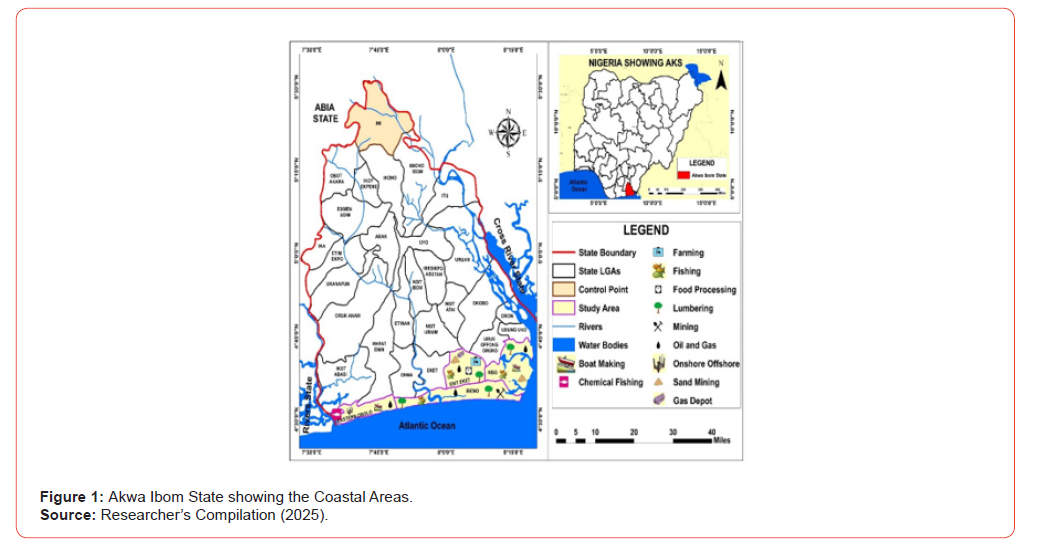
The study is located in the coastal region of Akwa Ibom State, southeastern Nigeria, which lies within the southern part of the Niger Delta. The state is bordered to the south by the Atlantic Ocean (Bight of Bonny), giving it an extensive coastline characterized by low-lying terrain, mangrove swamps, estuaries, and tidal flats. The coastal zone includes several Local Government Areas (LGAs) such as Eket, Esit Eket, Ibeno, Eastern Obolo, Mbo, Oron, and parts of Ikot Abasi, which collectively form the main focus of coastal environmental and groundwater-related studies in the state. Geographically, the area lies approximately between 4°30’N to 5°30’N latitude and 7°30’E to 8°30’E longitude, and is part of the coastal plain sands aquifer system of the Niger Delta basin. The terrain is generally flat and low-lying, with elevations rarely exceeding 50 meters above sea level. This physical setting makes the area highly susceptible to flooding, tidal influence, and saltwater intrusion into shallow groundwater systems. The climate of the study area is tropical equatorial, characterized by high rainfall (often exceeding 2,500 mm annually), high humidity, and relatively stable temperatures ranging between 24°C and 32°C. The region experiences two main seasons: the rainy season (March–November) and the dry season (December–February). Heavy rainfall and poor drainage conditions contribute significantly to surface waterlogging and groundwater recharge, while also increasing the risk of contaminant transport into shallow aquifers. Hydrogeologically, the coastal aquifers of Akwa Ibom State are composed mainly of sands and sandstone formations, which are highly permeable and productive but also vulnerable to contamination. Groundwater is the primary source of drinking water for most rural and peri-urban communities due to limited access to centralized piped water supply. However, the shallow nature of boreholes and wells, combined with proximity to the coastline, makes these water sources highly sensitive to both seawater intrusion and surface-derived pollution.
The region attracts massive economic activities ranging from fishing, hunting, farming, canoe building and oil and gas services. The agricultural sector is favorable supporting a wide variety of oil palm, cocoa, rubber, cassava, yam, maize, rice and vegetables. The coastal area of the state also has a significant aquaculture industry, with fishing and fish farming being a common agricultural activity. Livestock farming, including poultry, pig, and goat rearing, is also practiced in the coastal area of the state. Agricultural waste generated from pesticide, herbicide, animal faecal matter contributes to water contamination in the coastal region. Mbo LGA is located in Akwa Ibom State, Nigeria, and is characterized by a mix of rural and semi-urban settlements. The area is known for fishing, agriculture, and emerging industrial activities, which can contribute to groundwater pollution (Akpan and John, 2018) [42]. Mbo is also home to numerous oil wells, attracting substantial human and vehicular traffic, including heavy machinery for oil drilling and exploration, often involving collaborations between Nigeria and China. The local economy is further stimulated by these activities, and Mbo consists of approximately 60 villages divided into coastal and upland regions. The primary economic activities in Mbo include fishing, subsistence farming, fuelwood exploitation, trade, and water transportation. The area’s natural resources and proximity to water bodies make these activities central to the local economy. The primary occupations of Mbo residents are fishing, marine transportation, and subsistence farming. Fishing is a primary occupation and economic mainstay in Mbo, carried out in the rivers and coastal regions. The area is rich in creeks and estuaries, such as Esuk Mma, Esuk Unyeneye, Ibaka and TomShot Island, which support fishing settlements (Udom, Okon and Essien, 2019) [43].
Eastern Obolo and Ibeno Local Government Areas (LGAs) are located in Akwa Ibom State, Nigeria. The region’s abundant water resources make it a focal point for oil exploration and other waterbased economic activities, including fishing, marine transportation, and subsistence farming. The local population in Eastern Obolo speaks the Obolo dialect, while the Ibenos speak Ibeno local dialect with a touch of Obolo in some areas, but generally there seemed to be variations. Esit Eket is rich in natural resources such as gravel, oil and gas and clay deposits, fisheries as well as forest reserves abundant in timber, fruits (mangoes, oranges, and pears), and cash crops like palm fruit. Ini Local Government Area is one of the many local government areas in Akwa Ibom State that are farther away from the coast. The area is widely known for agricultural potential, majorly rice farming. Major economic trees found ranges from gmelina, oil palm, mango, native pear and star apple. There is a network of rivers that crisscrossed undulating plains that make up the regions (Akpan and John, 2018) [42]. Due to rough topography, gullies eat up a larger segment of the cultivable land. Erosion and flood are the major ecological problem therein. Moreover, more than 4 rivers are situated within the geographical terrain and active sand mining pose a challenge to groundwater in that region. Connecting human activities to groundwater management, pesticide and metal pollutants from sand mining are the major contaminant. Nevertheless, the effect of human activities on groundwater in Ini Local Government Area cannot be compared with those in the coastal fringes (see Figure 1.2).
Methods
This study adopted a mixed-method research design combining descriptive, analytical, survey, and field-based approaches to investigate drinking water contamination and related community experiences in coastal communities of Akwa Ibom State, Nigeria. The study was carried out in five selected Local Government Areas (LGAs), namely Mbo, Ibeno, Esit Eket, Eastern Obolo, and Ini (used as an inland control site outside direct coastal influence), chosen purposively based on their exposure to coastal processes, petroleum-related activities, fishing, and wetland agriculture. Within the coastal LGAs, two communities were selected per LGA, following reconnaissance surveys to familiarize with settlement patterns and environmental conditions, and the communities were further classified into coastal island settlements, Atlantic shoreline settlements, and upland settlements to capture spatial variability in environmental exposure. The study population comprised households within these communities, and a sample size of 314 respondents was determined using the Bill Godden (2004) finite population formula, with purposive sampling applied to ensure inclusion of communities directly influenced by coastal and anthropogenic stressors.
Primary data were obtained through structured questionnaires administered to household heads to obtain information on sources of drinking water, perceived contamination indicators such as changes in taste, colour, and odour, and reported health outcomes including waterborne diseases, while semi-structured interviews provided deeper qualitative insights into lived experiences such as seasonal water scarcity, distance travelled to obtain potable water, economic burden of water access, and coping strategies. In addition, direct field observations were carried out to document visible environmental and infrastructural sources of contamination, including proximity of water points to waste dumpsites, poor drainage systems, flooding-prone areas, oil exploration and production infrastructure, and borehole siting practices, particularly the proximity of wells to sanitation facilities and other pollution sources. Water sampling was conducted in both dry and wet seasons, with a total of 18 groundwater samples collected from boreholes across the selected communities, using sterilized onelitre pre-labelled bottles to prevent contamination.
Before sample collection, boreholes were allowed to run for approximately three minutes to stabilize flow conditions, and samples were immediately sealed to prevent aeration and loss of dissolved gases. Two sets of samples were collected, one for physicochemical and ionic analysis and another for microbial analysis, with samples for cation determination preserved using dilute hydrochloric acid, while microbial samples were collected in sterile McCartney bottles. All samples were transported in iced cool boxes to the State Water Laboratory under the Ministry of Science and Technology, Uyo, for analysis, and in-situ measurements of parameters such as pH and electrical conductivity were taken using portable digital meters at the point of collection to preserve sample integrity. Laboratory analysis covered physicochemical parameters including pH, temperature, turbidity, total dissolved solids (TDS), total suspended solids (TSS), electrical conductivity, total hardness, alkalinity, and acidity; major ions and nutrients such as chloride, nitrate, bicarbonate, sulphate, sodium, and calcium; trace and heavy metals including iron, cobalt, copper, cadmium, lead, chromium, mercury, and arsenic; and microbial indicators including total coliform and faecal coliform counts using standard microbiological methods. All analytical results were compared with World Health Organization (WHO) permissible limits to determine water suitability for drinking purposes.
Quantitative data from laboratory results and questionnaires were analyzed using descriptive statistics such as frequencies, percentages, and means, while inferential analysis was applied where necessary to explore relationships between environmental conditions and water quality outcomes. Qualitative data obtained from interviews were analyzed thematically by coding recurring responses into key patterns relating to perceived contamination, health impacts, and water access challenges. Overall, the methodological framework was designed to directly address the study objectives by identifying contamination sources through field observation and sampling, examining community perceptions of drinking water quality, documenting visible environmental and infrastructural pollution risks, and assessing the relationship between observed environmental conditions and communityreported experiences of drinking water contamination through integrated analysis of quantitative and qualitative data.
In Table 1, sampling location as categorized into coastal island, Atlantic shore and uplands was presented. Coordinates were taken at the sampled water point for mapping while varying socio-economic activities that are pre-dominant in each sampling locations were outlined (see Table 1).
Table 1: Sample Boreholes
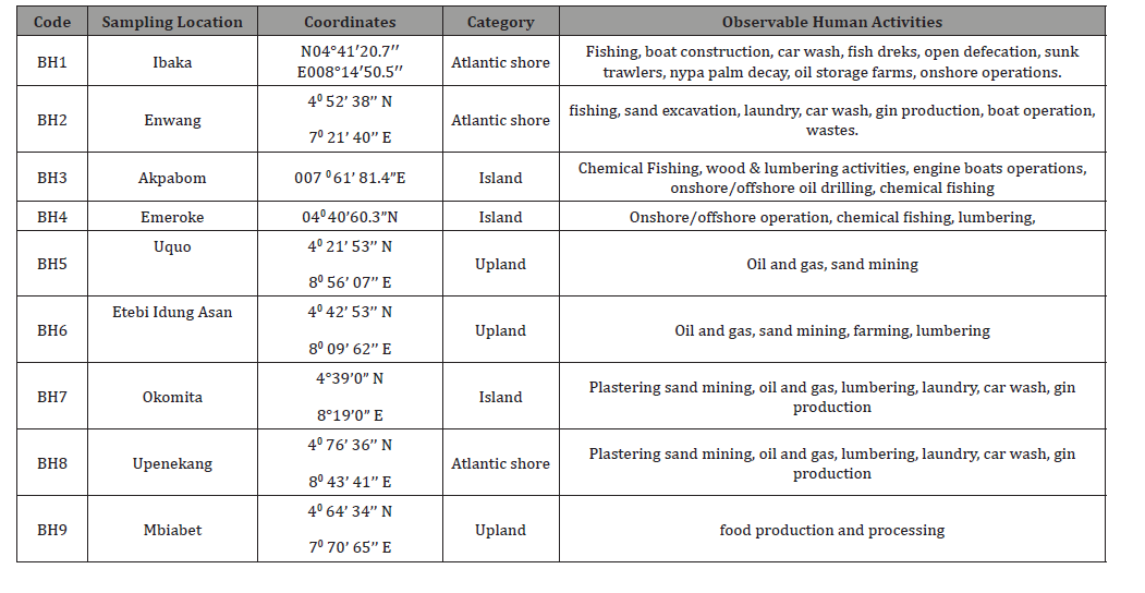
Source: Field Data (2025).
Results and Findings
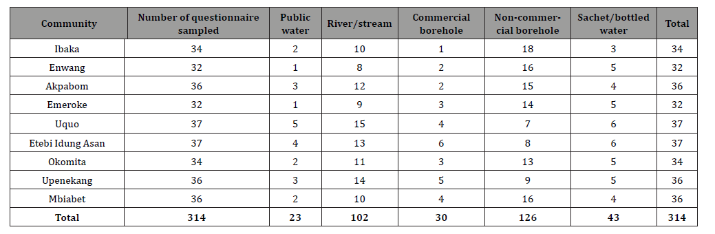
Table 2 reveals that a significant majority of households (40.1%) rely on borehole as their primary source of drinking water, followed closely by rivers/stream (32.5%). This indicates a heavy reliance on private water sources. The low number of respondents using piped public water (7.3%) suggests that governmentsupplied water infrastructure is either not widely available or not a preferred source, possibly due to inconsistency or poor quality. This finding points to a gap in the implementation or maintenance of public water policies in the studied coastal communities.
Table 2: Primary Source of Drinking Water. Source: Field Data (2025).
The analysis as presented in Figures 2-5 shows the laboratory analysis of surface water sample for wet season. The physicochemical analysis of drinking water in coastal Akwa Ibom reveals significant seasonal fluctuations and a high degree of anthropogenic impact. Turbidity levels are notably higher in the wet season (11.4–22.6 NTU) compared to the dry season (4.2– 8.6 NTU). This increase is likely driven by terrestrial runoff and sediment suspension common in coastal terrains during rains. Both seasons show a critical failure in bacteriological safety. Total coliform counts peak in the wet season, reaching 390 CFU/100mL at BH5, suggesting that runoff transports fecal matter and surface pollutants into the groundwater system. Electrical conductivity (E.Cond) and Total Dissolved Solids (TDS) show marked increases during the dry season, particularly at BH5 and BH6. This suggests concentrated mineralization and potential saltwater intrusion due to reduced freshwater recharge. While the pH generally remains within a slightly acidic to neutral range (5.7–7.5), BH5 and BH8 exhibit higher acidity levels in both seasons, which can increase the solubility of heavy metals.
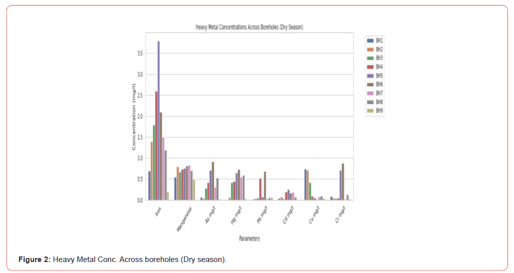
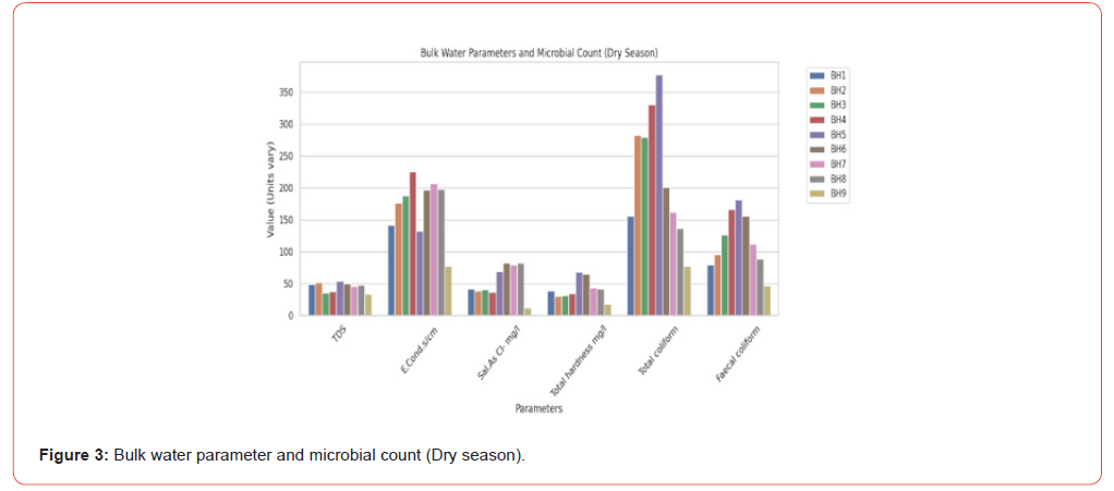
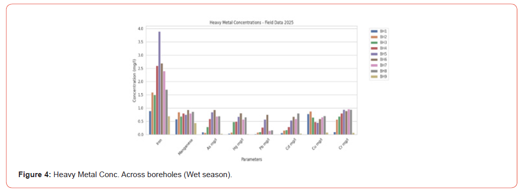
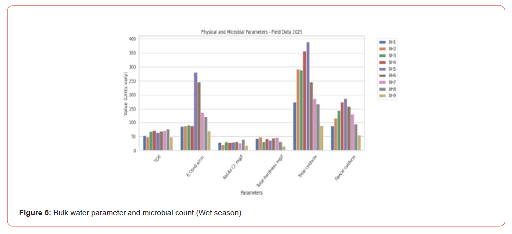
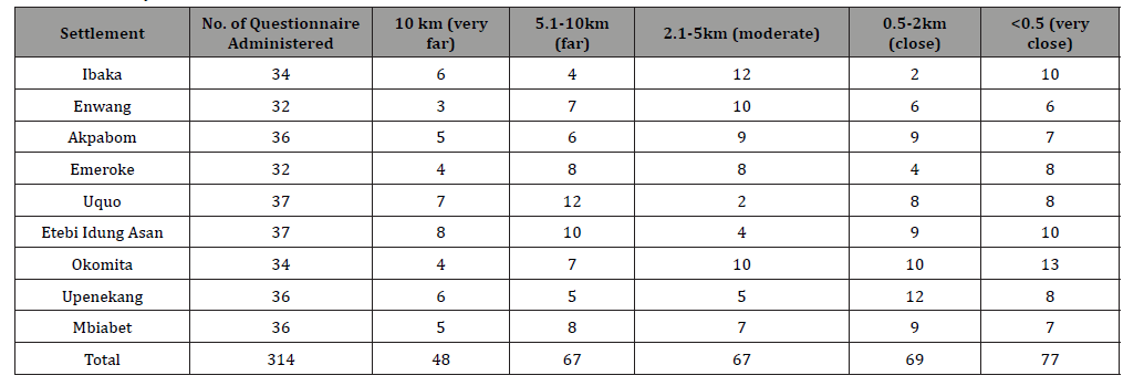
Heavy metal stress is a persistent concern. Iron (Fe) levels consistently exceed safety standards in both seasons, peaking at 3.9 mg/l in the wet season. This high concentration is characteristic of the Niger Delta’s geological formation but is exacerbated by industrial effluents. Furthermore, Arsenic (As), Mercury (Hg), and Chromium (Cr) show detectable and rising concentrations during the wet season. This trend suggests that rain-induced leaching from industrial sites—such as oil facilities and poorly managed waste dumps—facilitates the migration of toxic trace elements into the coastal aquifers. The data in Table 3 shows that a significant portion of the surveyed population lives in close proximity to an industrial site. The most common responses are “very close” (<0.5 km) with 77 respondents and “close” (0.5-2 km) with 69 respondents, representing over 46% of the total sample. Okomita has the highest mean score of 8.17 and the most respondents in the “very close” category, suggesting it is the most directly impacted community. Conversely, Uquo has the highest number of respondents who feel they are “far” or “very far” from an industrial site. This data highlights a potential for environmental pollution related to industrial activity.
Table 3: Proximity to Industrial Site.
Source: Field Data (2025).
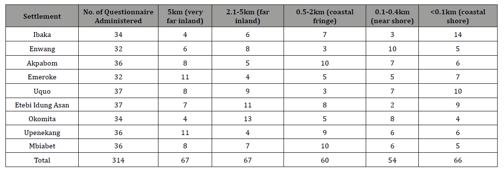
Tables 4 reveals that the communities are distributed across a wide coastal zone, from being very far inland to right on the shore. While there is a high concentration of people residing “very far inland” (67 respondents) and “far inland” (67 respondents), an almost equal number of residents are on the “coastal shore” (66 respondents). This mixed distribution highlights the varied geographical settings of the surveyed communities and their potential exposure to sea-related environmental factors.
Table 4: Closeness to Open Sea.
Source: Field Data (2025).
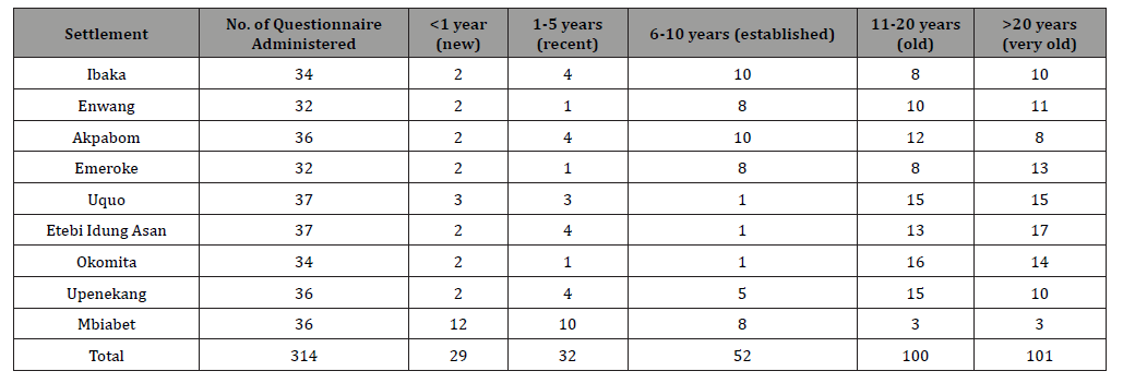
The data reveals that the majority of boreholes in the surveyed communities are aging. A total of 201 respondents (64%) reported that their boreholes were “old” (11-20 years) or “very old” (>20 years). This raises concerns about water quality, infrastructure integrity, and the potential for a decline in water availability. Okomita has the highest number of old boreholes, with a mean of 3.39, while Mbiabet is the only community with a significant number of new and recent boreholes, as reflected by its high mean of 6.13.
Table 5: Age of the Borehole.
Source: Field Data (2025).
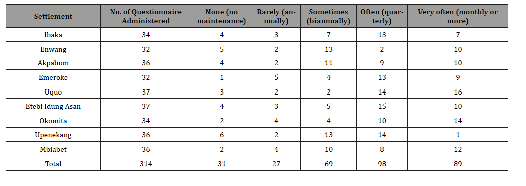
Table 6 shown a mix of maintenance practices across the communities. While a large number of respondents reported that maintenance is performed “Often” (98) or “Very often” (89), a considerable number also reported “None” (31) or “Rarely” (27). This suggests that while some communities have established maintenance routines, others do not. Uquo and Okomita, for example, have a high number of respondents reporting frequent maintenance, while Upenekang and Enwang have a significant number reporting a lack of maintenance. The overall data indicates a need for more consistent and widespread maintenance protocols.
Table 6: Regular Maintenance.
Source: Field Data (2025).
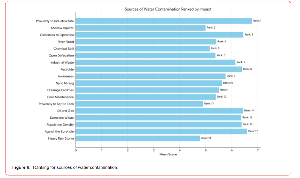
Sources of water contamination (Using Mean Rank Score)
The sources of water contamination were determined by ranking the mean of the aforementioned variables obtained from the instrument. This summary table ranks various factors potentially influencing water quality and public health outcomes, based on their “Value,” which likely represents an average score or perceived importance (though the scale isn’t specified). The data provided lists 18 variables that contribute to water contamination, ranked based on their significance. Proximity to Industrial Sites is identified as the leading cause of contamination, followed by geographical factors like Shallow Aquifers and Closeness to the Open Sea. Interestingly, while some variables have higher mean scores (like the “Age of the Borehole”), they are ranked lower in terms of overall impact or priority within the study’s context.
Conclusion and Recommendations
This study establishes that drinking water safety in coastal Akwa Ibom State, Nigeria, is profoundly compromised by the intersection of hydrogeological vulnerability and anthropogenic activities. By integrating field-based hydrochemical data with community perceptions, the research demonstrates a critical degradation of groundwater quality, particularly pronounced during the wet season. Laboratory assessments confirm that multiple borehole systems across Mbo, Ibeno, Esit Eket, and Eastern Obolo exhibit levels of turbidity, electrical conductivity, total dissolved solids, heavy metals (iron, arsenic, and chromium), and microbial pathogens that significantly exceed World Health Organization (WHO) permissible limits. Conversely, these impacts were noticeably lower in the inland control site of Ini Local Government Area, reinforcing the unique vulnerability of the coastal aquifer matrix. The investigation reveals that groundwater degradation is driven by a combination of natural and human-induced factors. Geogenic processes, specifically seawater intrusion, are exacerbated by localized human activities. Anthropogenic pressures—including oil exploration, poor municipal waste management, industrial effluent discharge, and inadequate separation distances between shallow boreholes and sanitation facilities (such as pit latrines)—serve as primary pathways for chemical and biological vectors. The lived experiences of the residents validate these scientific findings; communities frequently report organoleptic deterioration of their water supply, including unpleasant tastes, odors, and visible discoloration. This decline in water quality correlates directly with an increased incidence of waterborne diseases among the coastal population. Ultimately, the coastal plain sands aquifer system is undergoing progressive degradation, indicating that current localized water extraction and sanitation practices are unsustainable and pose an immediate threat to regional public health and long-term development.
To safeguard public health and ensure the sustainability of groundwater resources in coastal Akwa Ibom State, the following policy interventions are recommended: The Akwa Ibom State Ministry of Water Resources, in partnership with academic institutions, should deploy a network of monitoring wells across vulnerable coastal Local Government Areas. This network must conduct continuous, seasonal hydrogeochemical and isotopic tracking to map the freshwater-saltwater interface, detect early signs of seawater intrusion, and monitor heavy metal propagation. Secondly, regulatory bodies must strictly enforce minimum setback distances (minimum of 30 meters) between domestic water wells and localized pollution sources, such as pit latrines, septic tanks, and community waste dumps. Shallow, unconfined borehole construction should be discouraged in favor of deeper, properly sealed confined aquifer abstraction to bypass surface-derived microbial and chemical pollutants. Thirdly, the State Environmental Protection Agency (AKSEPA) must transition coastal communities away from open dumping and unlined pit latrines. Investing in centralized, flood-resilient sanitary facilities and engineered landfill systems is critical to eliminate toxic leachate migration into the high-water-table aquifers of the Niger Delta. Lastly, given the heavy metal and hydrocarbon footprints linked to oil exploration and sand mining, regulatory agencies must enforce strict effluent discharge limits. Multi-national and local oil-servicing firms operating in zones like Mbo and Ibeno must be held accountable through regular environmental audits and mandatory corporate social responsibility (CSR) investments in centralized water treatment plants.
References
- Nickson RT, McArthur JM, Shrestha B, Ravenscroft P (2005) Global distribution of arsenic and heavy metals in shallow coastal aquifers: A review of environmental health threats. Applied Geochemistry 20(1): 55–71.
- Foster SS (1998) Groundwater recharge and vulnerability mechanisms in urbanizing coastal plain sand systems. Geological Society, London, Special Publications 130(1): 17–28.
- Chidambaram S, Anandhan P, Vasudevan S, Pradeep K (2008) Hydrogeochemical assessment of hydrogeological vulnerability and seawater intrusion pathways in unconfined coastal plain sand aquifers. Hydrogeology Journal 16(5): 945–961.
- Edet, AE (2016) Groundwater quality assessment in coastal plain sand aquifers of southern Nigeria: Implications for governance and management. Environmental Earth Sciences 75(9): 782.
- Antai SP, Edet AE, Asuquo FE (2023) Hydrochemical characteristics and public health risks of coastal groundwater in the Niger Delta region. African Journal of Environmental Science and Technology 17(4): 189–204.
- Muhammad S, Shah MT, Khan S (2011) Microbial pathogens and geogenic contaminants in drinking water pathways: Global burden of waterborne infections. Food and Chemical Toxicology 49(11): 2712–2721.
- Ormachea M, Bhattacharya P, Aris R (2013) Heavy metal enrichment and waterborne pathogen dynamics in rural unconfined aquifers. Journal of Hazardous Materials 262: 934–945.
- Singh R, Singh S, Parihar JS (2018) Waterborne pathogens, acute diarrhea, and enteric virus outbreaks linked to shallow well abstraction. Epidemiology and Infection 146(9): 1123–1134.
- Karthikeyan S, Sekar S, Rajmohan N (2022) Contaminant migration pathways through fractured rock systems in coastal unconfined aquifers. Journal of Contaminant Hydrology 246: Article 103960.
- Vimalathithan R (2016) Hydrogeological variations and chemical suitability of groundwater in flood-prone sedimentary coastal terrains. Journal of Hydrology 540: 1118–1131.
- Zamrsky D, Bierkens MF, Global Coastal Aquifer Initiative (2020) Geological variability, sedimentary deposition, and storage capacity variations in global coastal aquifer systems. Earth System Science Data 12(4): 2843–2862.
- Lesser LE, Mora A, Aquifer Assessment Network (2018) Hydrogeological variations and unconfined shallow aquifers of low-lying sedimentary coastal deltas. Earth-Science Reviews 185: 512–529.
- Luo Z, Yeh HD, Aquifer Dynamics Lab (2021) The role of boundary conditions and geometry in controlling seawater intrusion advance. Advances in Water Resources 149: Article 103845.
- Hanif M, Mahlknecht J, Technical Working Group on Aquifer Geometry (2020) Structural influence of divergent and convergent geometries on coastal aquifer salinization dynamics. Water Resources Research 56(11): e2020WR027532.
- Laluraj CM, Gopinath G, Dineshkumar PK (2005) Groundwater chemistry and microbial contamination risks in coastal aquifers of Kerala, India. Environmental Geology 48(8): 1012–1020.
- Emuobonuvie OT, Mensah JK, Asante F (2024) Water Quality Index (WQI) and geogenic enrichment of trace metals in sedimentary coastal aquifers of West Africa. Environmental Science and Pollution Research 31(6): 8912–8927.
- Mwakio TM (1997) Pit latrine placement, septic effluent, and E. coli distribution in shallow coastal boreholes of Kwale District, Kenya. Discovery and Innovation 9(3): 167–176.
- Li J, Zheng C, Climate Variability Group (2019) Modeling the impacts of sea level rise and dynamic groundwater extraction on saltwater encroachment. Journal of Hydrology 575: 1211–1224.
- Wahyono S, Utomo SB, Southeast Asian Coastal Network. (2022) Storm surges, low elevation, and tidal flooding threats to groundwater systems in major deltaic plains. Marine Pollution Bulletin 174: Article 113205.
- Adebo EA, Adetoyinbo AA (2009) Assessment of groundwater quality and seawater intrusion in coastal aquifers of Lagos, Nigeria. Environmental Geology 56(8): 1597–1606.
- Ajibade OM, Olarinoye IO, Adegoke JA (2010) Heavy metal contamination in groundwater systems of urbanized sedimentary terrains. International Journal of Environmental Sciences 1(3): 342–355.
- Nwankwoala HO, Udom GJ (2011) Hydrochemical evaluation and saltwater-freshwater interface mapping in parts of the Niger Delta, Nigeria. Journal of Mining and Geology 47(2): 145–156.
- Essang DB, Udofia U, Imikan A (2024) Heavy metal enrichment and health risk indices of borehole water in oil-producing zones of Mbo Local Government Area, Nigeria. Journal of African Earth Sciences 210: Article 105124.
- Brindha K, Kasinatha P (2011) Nitrate contamination in shallow coastal aquifers due to agricultural practices and sanitation leakage. Environmental Monitoring and Assessment 178(1): 247–256.
- Hudak PF, Thapinta A (2005) Organochlorine and organophosphate pesticide residues in shallow groundwater beneath tropical agricultural catchments. Environment International 31(5): 679–687.
- Navarrete IA, Interino RE, Medinat JM (2018) Persistent organochlorine residues in groundwater matrices of tropical agricultural systems in Southeast Asia. Agriculture, Ecosystems & Environment 265: 34–45.
- Lang X, Wang Q, Singh BP (2015) Hydrocarbon pollution and heavy metal migration dynamics in industrial coastal zones. Marine Pollution Bulletin 95(1): 223–234.
- Publio LS, Silva MA, Alcantara R (2023) Hydrocarbon footprint and aquifer vulnerability index in urbanized petroleum exploitation zones. Environmental Monitoring and Assessment 195(2): Article 294.
- Peter GJ (1997) Separation distances, nitrate loading, and faecal coliform contamination of unconfined aquifers on tropical islands. Water Science and Technology 35(8): 113–121.
- He L, Zhao Y, Zhang X (2020) Over-pumping, land subsidence, and inland salinization pressures in China’s coastal plains. Journal of Hydrology 582: Article 124510.
- Prasad R, Kumar D, Regional Development Forum (2022) Declining water tables, aquifer compaction, and inland salinization in low-lying deltaic terrains. Environmental Management 70(3): 482–499.
- Van Biersel TP, Carlson DA, Milner LR (2007) Impact of flooding and hurricanes on groundwater quality in unconfined coastal plain sand systems. Environmental Geology 53(3): 615–626.
- Nordio G, Carniello L, Venice Coastal Resilience Consortium (2023) Storm surges, tidal flooding, and vertical contaminant transport pathways in unconfined coastal aquifers. Water Resources Research 59(4): e2022WR033412.
- Ngare IO, Olago DO, Ayiti J (2024) Institutional frameworks, weak enforcement, and groundwater degradation in rapidly expanding coastal settlements. Environmental Science & Policy 152: 103652.
- Ochoo B, Valcour J, Sarkar A (2017) Aesthetic properties, sensory indicators, and trust in municipal supply: Disconnects between public perception and laboratory metrics. Science of the Total Environment 599: 1313–1322.
- Wright JA, Yang H, Gundry SW (2012) Organoleptic qualities vs. socio-economic status: What shapes risk perception of drinking water safety in rural South Africa? Water SA 38(5): 721–730.
- Lome Hurtado A, Martinez Cruz AL, Juarez Torres M (2026) Organoleptic properties, aesthetic anomalies, and health risk perceptions: Household response to tap water odor in coastal Mexico. Water Policy 28(1): 67–83.
- Gevera PK, Mouri H, Maronga G (2022) Sensory indicators vs. laboratory metrics: Assessing community risk perception of groundwater quality in coastal Kenya. Human and Ecological Risk Assessment 28(3): 412–430.
- Ramya S, Jeenath P, Subba Rao N (2021) Disconnects between sensory evaluations and biological-chemical indices of safe drinking water in South India. Environmental Earth Sciences 80(14): Article 462.
- Ocheri MI, Mile II, Orakwe LC (2014). Solid waste dumpsites and leachate-induced chemical pollution of shallow groundwater systems in urban settlements. Journal of Environmental Protection 5(12): 1109–1118.
- Kponee KZ, Chiger A, Kakulu S, Ord J (2015) Petroleum hydrocarbon footprints in rural drinking water wells of the Niger Delta: Lived experiences and acute health symptoms. Environmental Health 14(1): Article 88.
- Akpan ER, John UE (2018) Anthropogenic pressures and environmental sustainability of rural-urban fringes in Akwa Ibom State. Nigerian Journal of Geography and Environment 12(1): 45–58.
- Udom GJ, Okon EE, Essien OU (2019) Hydrogeochemical characteristics of creeks and estuaries supporting fishing settlements in Mbo Local Government Area, Nigeria. International Journal of Environmental Studies 76(5): 789–804.
-

This work is licensed under a Creative Commons Attribution-NonCommercial 4.0 International License.


 a Creative Commons Attribution 4.0 International License. Based on a work at www.irispublishers.com.
Best viewed in

 | Above IE 9.0 version | Privacy Policy