


 Research article
Modeling Sea Level Rise Impacts on Sea Water Intrusion into Gaza Strip Aquifer
Received Date: July 22, 2025; Published Date: August 01, 2025
Abstract
The aquifer in the Gaza Strip is suffering from the problem of salinization of ground water resulting due to seawater intrusion into the aquifer.
In this article, an assessment of the rise of sea level (one of the climate changes factors) that may contribute to increase the seawater intrusion to
groundwater was carried out. The sea level rise is expected to reach about 37 cm by the middle of this century (2050). The assessment of the impacts
was through the use of numerical method (Modeling). Rainfall recharge maps were created using the GIS program for the years 2010-2016. About
40% of the rainfall reaches to groundwater, and was used during modeling seawater intrusion into the aquifer in the Gaza Strip for the extended
modeling period in 2050. The impact of sea level rise on seawater intrusion into the aquifer was assessed by the change chloride concentration in
the aquifer using the Modflow program to create flow model and Seawat model to determine sea water intrusion into the Gaza aquifer. Two scenarios
were considered: the first scenario was without the effect of sea level rise, while the second with the effect of rising sea level.
The results showed that the aquifer in the Gaza Strip will suffer from the arrival of sea water to 2788m and 2858m from the sea shore line
in Rafah city in the south in 2032 under the first and second scenarios respectively. The intrusion will reach one third of the aquifer in 2050, in
addition to more than half of the aquifer will contain a chloride concentration up to 2000 mg/l. In relation to the effect of sea level rise on sea water
intrusion into the aquifer, the results showed an increase in sea water intrusion into the aquifer not exceeding 100 meters in year 2050. This is a
small contribution to the sea water intrusion compared to other factors that cause sea water intrusion into aquifer such as over pumping from the
aquifer and reduction in the aquifer recharge.
Keywords: Seawater intrusion; sea level rise; climate change; gaza strip
Introduction
The aquifers are an important resource in coastal regions because these serve as major sources for freshwater supply in many countries around the world, especially in arid and semi-arid zones [1]. Groundwater is the only natural source that feeds the population in fresh water in the Gaza Strip about 98% of consumption, most of these coastal regions rely on groundwater as their main source of fresh water for domestic, industrial and agricultural purposes [2,3]. The aquifer in Gaza suffers from the problem of “sea water intrusion into the aquifer” and the rest of the coastal aquifers around the world, producing the problem of increasing salinity in these aquifers. Seawater intrusion is affected by several direct factors, for example, rate of pumping from wells, rainfall rates, soil type and layers conductivity, as well as indirect factors resulting from changes in climate can influence the seawater intrusion, such as tidal fluctuations, long-term climate and sea level changes, fractures in coastal rock formations and seasonal changes in evaporation, recharge rate [4].
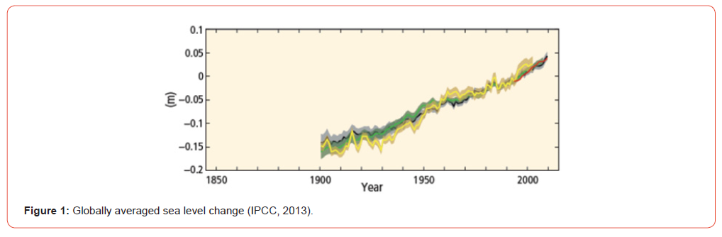
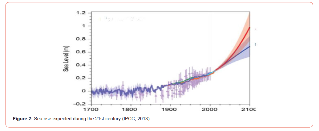
Sea level rise is a major result of global warming due to climate change (Church et al., 2008), Warming of the climate system is unequivocal, and since the 1950s, many of the observed changes are unprecedented over decades to millennia. The atmosphere and ocean have warmed, the amounts of snow and ice have diminished, and sea level has risen [5]. IPCC Fifth Assessment Report that sea level rise during the 2000s B.P did not exceed a few tens of millimeters, then during the nineteenth century rates have become even greater, the rate during 1901-1990 was 1.5 (1.3 to 1.7) mm/yr, and increased by doubling during 1993-2010 was 3.2 (2.8 to 3.6) mm/ yr, as shown in Figure (1). It is expected to exceed this rate during the 21st century, until sea level reaches about 0.88-1.1 m, Figure (2) show the expectations of sea level rise during the twenty-first century. Since the start of the 21st century the Mediterranean Sea Level has already risen by 20 centimeters and it has risen by between 1 and 1.5 millimeters each year since 1943, but this does not seem set to continue, because it now seems that the speed at which it rises is accelerating (PHYS.ORG,2011). In Palestine, the measurements conducted in the late 20th century in the Haifa city indicated a rise in the Mediterranean level by 2.8 mm / year [6]. There are studies attributed to the Israeli Ministry of Environment to increase the level of sea by 10 mm / year [7]. The Mediterranean Sea is expected to reach 37 cm by mid-century (2050).
Werner & Simmons, 2009 [8] tested two models: (1) flux-controlled systems, (2) head-controlled systems, with sea level rise at 880 mm. The results indicated that the sea water intrusion into the aquifer did not exceed 50 meters under the conditions of Flux Controlled Systems, while hundreds of meters exceed the kilometers under the Head Controlled Systems. Lo´aiciga et al., 2012 [9] tested of three different scenarios in terms of sea level rise expected for 2106 estimated at 1.903, 1.403 and 0.903 m for the three scenarios, respectively. The results of the analysis showed the conditions of the first scenario, offering a line of 10,000 mg / liter to the shore about 760 meters, while the line of 1000 mg / liter is about 1200 meters, The results are very similar between the second and third scenarios with the results of the first scenario, with a slight increase in the progress of the line of 10,000 and the line of 1000 mg / liter ranging from 10 to 15 meters only. Langevin & Zygnerski, 2013 [10] used of four sea level rise rates “ 0.0, with linear increase 24, 48 and 88 cm/ century “ respectively. The result showed sea water intrusion rates were 15, 17, 18, and 21 m/year for the 0, 24, 48, and 88 cm/century sea-level rise rates, respectively. In addition to the contribution of sea level rise of 25 cm to an increase in intrusion by 1 km to the land. Sefelnasr & Sherif, 2014 [11] showed an increase in saline areas by 15% with sea level rise from 0.5 to 1 m under the same conditions. Gejam et al., 2016 [12] indicated that the rise of the level of the Mediterranean “59 mm / year” led to an increase of sea water intrusion by 94 meters due to rise in the level of the sea in the western aquifer of Libya. The main aim of this article is an assessment the rise of the sea level, which is considered as one of the climate changes factors that may contribute to increase the sea water intrusion to groundwater was carried out. This is, the assessment of the impacts was through the use of numerical modeling approach and applied in Gaza strip aquifer.
Study Area
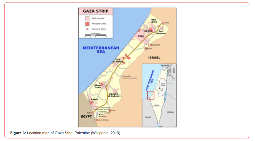
The Gaza Strip is a coastal strip east of the Mediterranean Sea located between longitudinal lines 34 °20 ‘’ and 34°25 ‘’E and latitudes 31°16 ‘’ and 31°45’’N (marefa.org). The Gaza Strip represents the southern governorates of the country with an area of 360 km2 estimated at 1.33 % of the total area, bordered by the south of Egypt along 11 km, while from the north and east occupied Palestine in 1948 by 51 km and the coast of the West by 41 km, as shown in Figure (3). The Gaza Strip is one of the highest densely populated areas in the all world. The population of the Gaza Strip was estimated at around two million by the end of 2016, with average density of about 5480 inhabitants/km2 (PCBS, 2016) [13]. The surface level of Gaza Strip is varies between sea level in some areas and 110 meters above sea level in the east formed a series of hills (wafainfo.ps).
Hydrological Parameters
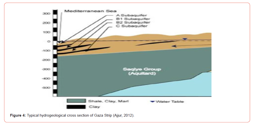
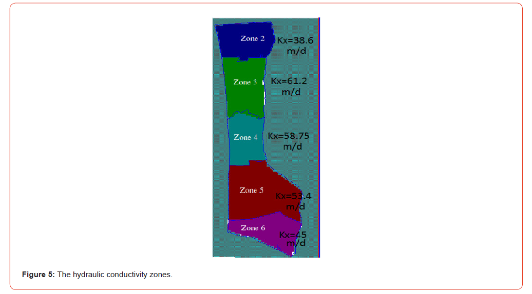
The aquifer located under the Gaza Strip is the only source of fresh water in the Gaza Strip. It is nourished by rainfall on the Gaza Strip and parts of the Negev and Hebron Mountains. The aquifer is composed of sand and sandstone, interspersed with layers of clay and clay sand, a four-tiered aquifer is formed near the coast, layer “ A” is unconfined, and three layers “ B1”, “ B2 “and “C” layers are confined as they approach the coast, as shown in Figure (4). The hydraulic conductivity of the aquifer ranges from 38 m/d to 61 m/d, Figure (5) shows the different hydraulic conductivity values. Table (1) shows the values of other properties for such as effective porosity, total porosity, specific storage, specific yield. The amount of water recharging the aquifer in the Gaza Strip is estimated at 80 Mm3 (45Mm3 recharge, 15 Mm3 lateral and 30Mm3 return flow) annually, compared with 130 Mm3 consumed from the aquifer (Gaza studies, 2017). The depth of water in the aquifer ranges from a few meters near the coast to 120 meters east, with the water level falling in most areas of the Gaza Strip under
Table 1: The other properties for layers (Aish, 2010).

Research Methodology
This article was done through a general understanding of the subject of sea level rise historically and locally through the competent authorities in this field in general and specifically the IPCC. In addition, the general understanding of the subject of sea water intrusion into the coastal aquifer through previous relevant research was also considered. This is followed by determining the study area for research and study of the aquifer and its characteristics by collected historical information about the study area such as climate, soil and topography of the region. The hydrological data was collected from relevant institutions such as Palestinian Water Authority (PWA) [15].
Recharge Model
Data collected for the production of aquifer recharge maps for the years 2010 to 2016 were used using the GIS program version 10.3 through soil map, built up area, land use and rain fall.
Modflow and Seawat Model
The Visual Modflow version 4.6 program was used to study the hydrological state of the coastal aquifer in the Gaza Strip. Seawat model used to evaluate the sea water intrusion into the Gaza aquifer through the following Equations. The governing flow and transport equations in Seawat are as in Equations (1) [6]:

where: Xi is ith orthogonal coordinate, Kf is equivalent freshwater hydraulic conductivity (L/T), Sf is equivalent freshwater specific storage (1/L), H f is equivalent freshwater head (L), T is time (T), θ is effective porosity (dimensionless), ρ is density of freshwater (M/ L3), ρs is density of sources and sinks (M/L3) and q s is volumetric flow rate of sources and sinks per unit volume of aquifer (1/T).
The transport Equation (2) (sarsak, 2011) [6] is:

where: Ck is dissolved concentration of species k (M/L3), Ck s is concentration of the source or sink for species k (M/L3), Di is the dispersion coefficient (L2/T), qs is the volumetric flux of a source or sink (T-1) and Rn is the chemical reaction term (ML3/ T).
The model boundaries (west, East, North and South) can be described as follows:
a. West: Constant head boundary during the year, increased linearly
from 0.20 m in 2016 to 0.37 m in 2050, about 50 mm /
year according to the IPCC projections for the rise of the Mediterranean
sea level during the current century, and Constant
concentration “ CL “ is 20,000 mg/l.
b. East: Variable head concentration boundary.
c. North: No-flow boundary.
d. South: No-flow boundary.
Prediction scenarios
This article examined the effect of sea level rise on sea water
intrusion into the aquifer during the simulation period until 2050,
Two scenarios were imposed:
a. The first scenario was for a period of 34 years extends from
2016 to 2050, with sea level rise of 0.0 m height and without
any change in pumping of wells from the aquifer.
b. The second scenario over a period of 34 years extends from
2016 to 2050, with sea level rise of 0.37 m height and without
any change in pumping of wells from the aquifer.
Discussion of the Results
Recharge Model
Figures (6-8) show the results of the recharge model using GIS software for years 2010, 2013 and 2016, respectively. The recharge of aquifer was approximately 40% of the rainfall. Figure (6) shows a decrease in rainfall between 30% to 52% over the average annual rainfall, resulting in a decrease in the amount of water reaching the aquifer.
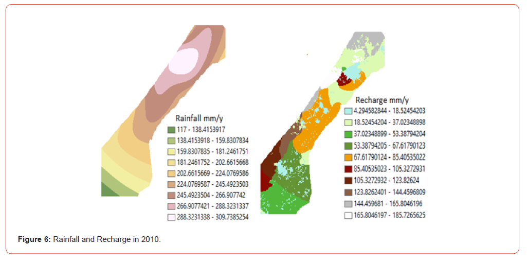
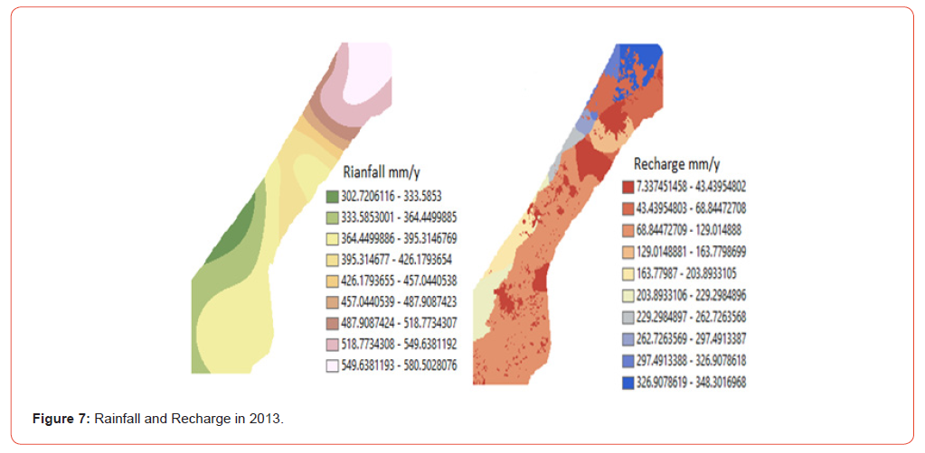
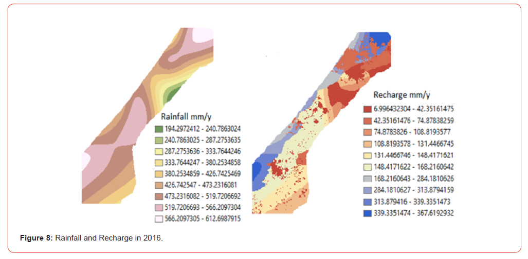
Figure (7) shows an increase in rainfall between 32% to 53% over the average annual rainfall, resulting in an increase in the amount of water reaching the aquifer.
Areas with low recharge rates indicate either the existence of clay layers in this area or built-up areas.
Groundwater flow and seawat modeling
After computing the values of recharge using GIS Model, these values were used as input to the groundwater flow model (Visual Modflow 4.6 software) and Seawat model. The outputs of the Seawat model will provide a good indicator of the impact of climate change “sea level rise” on the sea water intrusion into the coastal aquifer of the Gaza Strip. The model domain is grid of 80 column by 150 row, in the study area there were 234 municipal wells in 2016 and about 1694 registered agricultural well, 61 head observation wells were used to calibrating the model and 102 concentration observation wells. The models calibrated from 1 January 2010 as initial value to 31 December 2016. The calibration results presented to verify model confidence for 2013 and 2016. The correction coefficient for flow model calibration is 0.905 and 0.911, while the correction coefficient is 0.913 and 0.901 for seawat model calibration during 2013 and 2016, respectively. The calibration and the distribution of observed wells in the Gaza Strip showed a good accuracy in the prediction results of flow model and the seawat model.
Prediction of sea level rise Impacts
After calibration of the model using observation wells, the model is used for the future prediction phase to determine sea water intrusion dimension into aquifers due to climate change is “sea level rise”.
First Scenario: without the effect sea level rise
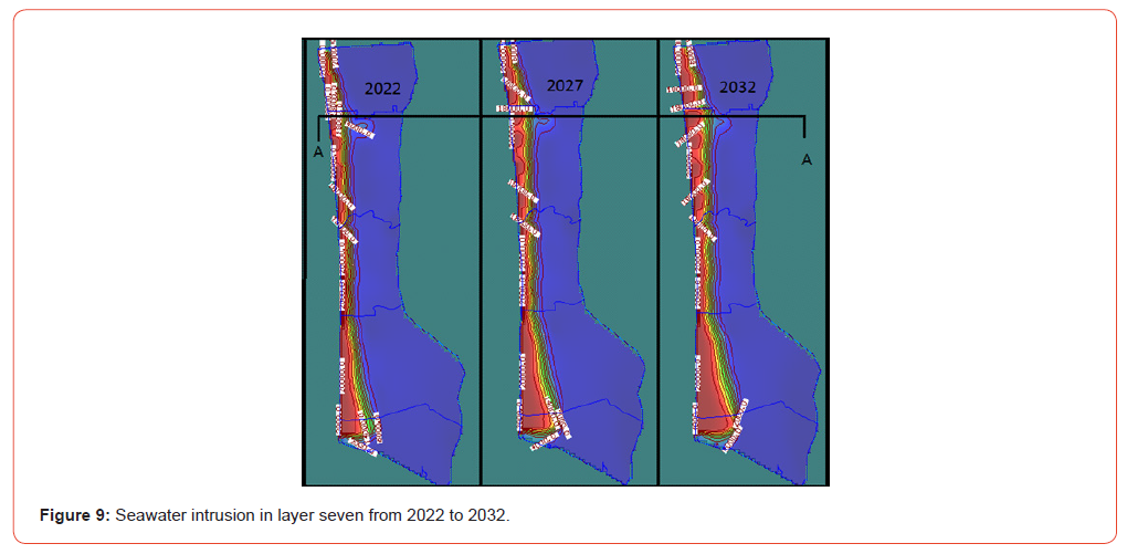
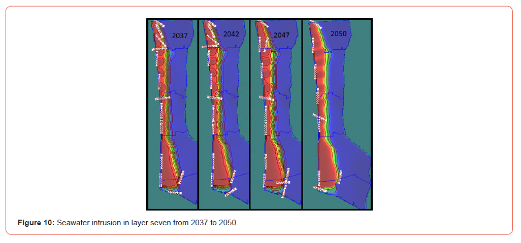
The 2016 data were used as initial values to run the model for 34 years with 0.0 m mean sea level. The results were extracted for every five years: 2022, 2027, 2032, 2037, 2042, 2047 to 2050 year. Figures 9 and 10 show the location of the seawater intrusion into the aquifer, specifically on the seventh layer from 2022 to 2050.
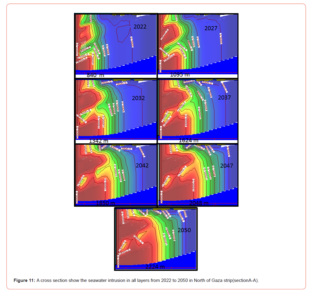
Figures 9 and 10 show the remarkable progress of seawater intrusion into the aquifer, where the 18000 mg / l line of chloride concentration reaches a distance of approximately 2500 meters from the shore (in land) by the beginning of 2030 and 3800 meters by 2050, while the 12,000 mg / l line is expected to reach to 4300 meters at the end of the modeling period (2050) in Rafah city. The area between the northern Gaza governorate and Gaza governorate and Rafah city are the most affected by seawater intrusion along the Gaza Strip. Figures 11 shows a cross section of aquifer in the area between the northern Gaza governorate and Gaza governorate, showing a distance of 18000 mg / L line of chloride concentration from shore for the years 2022 to 2050.
Second Scenario: with the effect of sea level rise
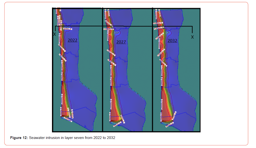
Under the same conditions as the first scenario and 2016 values but with sea level rise of 0.37 cm. Figures (12) and (13) show the modeling results for the second scenario for the years 2022 to 2050. Figures (12) and (13) show a slight increase in the results of sea water intrusion into aquifer compared with the results of the first scenario. Figures (14) shows a cross section of aquifer in the area between the northern Gaza governorate and Gaza governorate, showing a distance of 18000 mg/L line of chloride concentration from shore (in land) for the years 2022 to 2050.
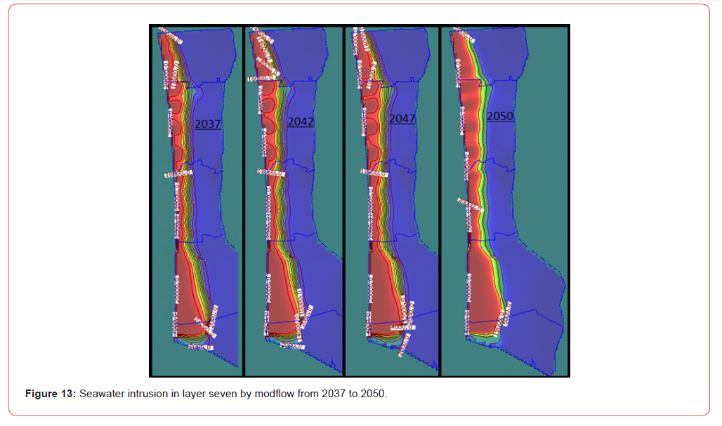
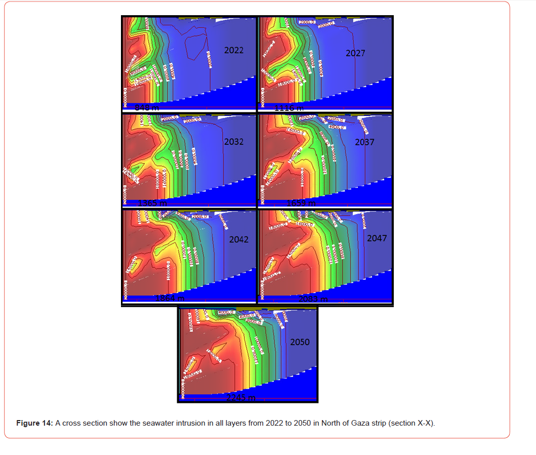
The results of the comparison between the two scenarios show that the contribution of sea level rise by 37cm led to increasing sea water intrusion into the aquifer by tens of meters (approximately 30 to 70 meters). These estimations are consistent with many research results that study the effect of Mediterranean sea level rise on the seawater intrusinon in coastal aquifers using analytical approach, such as: Sarsak, 2011 [6] estimated the impact of the sea level rise by 100 m in year 2035. Gejam et al., 2016 [10] indicated that the rise of the level of the Mediterranean sea led to an increase of sea water intrusion by 94 meters due to rise in the level of the sea. However, the results of the current article showed different results than the study of the aquifers of the Nile Delta carried out by Abd-Elhamid et al., 2016. This study indicated that the rise of the Mediterranean level by 100 cm will lead to additional interference of sea water to the aquifer in the Nile Delta by 10 km.
Conclusion
From the carried-out research it can be concluded that:
a. The problem of salinization of water in the aquifer is generally
clear in the Gaza Strip, especially in the area between the
northern governorate and the Gaza governorate and Rafah city.
b. The rise of the sea level is one of the factors that help enhance
the sea water intrusion into the aquifer in Gaza strip.
c. Sea level rise is not the most effective factor in the sea water
intrusion into the aquifer in Gaza Strip. A rise of 0.37 m in sea
level resulted in an increase of sea water intrusion to the aquifer
by 70 meters compared to the non-rise of sea level.
d. The results showed that the greatest impact of sea water intrusion
into the aquifer in Gaza Strip in the area between the
northern Governorate and Gaza Governorate and Rafah city.
e. More than half of the aquifer in Gaza Strip contains chloride
concentration of more than 2000 mg / l by 2037 and the rate of
chloride concentration increases as the years progress.
f. The majority of the areas in the Gaza Strip contain a concentration
of chlorine that is higher than the chlorine specified
drinking water standard which is 250 mg/L.
g. For this study it can be concluded that impact of over abstraction
from the aquifer on the seawater intrusion is rather more
than the impact of sea level rise.
References
- Naderi M, Kermani M, Barani G (2013) Seawater intrusion and groundwater resources management in coastal aquifers. European Journal of Experimental Biology 3(3): 80-94.
- Bably M, Abu neama T (2016) The reality of water in the Gaza Strip. Science in Arabic No.4.
- (2014) Palestinian Water Authority (PWA). Gaza Water Resources Status Report. Gaza, Palestine.
- Barlow P (2003) Ground water in freshwater-saltwater environments of the Atlantic coast. Science for a changing world, Circular 1262.
- (2014) Intergovernmental panel on climate change (IPCC). Technical Summary.
- Sarsak R (2011) Numerical simulation of seawater intrusion in response to climate change impacts in north Gaza coastal aquifer using SEAWAT. An-Najah National University, Palestine.
- Mogheir Y, Rabah F (2015) Training course on climate change and environmental sciences. Palestine.
- Werner A, Simmons C (2009) Impact of sea-level rise on sea water intrusion in coastal aquifers. Ground water 47(2): 197-204.
- Loaiciga H, Pingel T, Garcia E (2012) Sea water intrusion by sea-level rise: scenarios for the 21st century. Ground water 50(1): 37-47.
- Langevin C, Zygnerski M (2013) Effect of Sea-Level Rise on Salt Water Intrusion near a Coastal Well Field in Southeastern Florida. Groundwater 51(5): 781-803.
- Sefelnasr A, Sherif M (2014) Impacts of Seawater Rise on Seawater Intrusion in the Nile Delta Aquifer, Egypt. Groundwater 52(2): 264–276.
- Gejam A, Riad P, Gad M, Ashed K, Hasan N (2016) Climate Change and Sea Level Rise Impacts on Seawater Intrusion at Jefara Plain, Libya. Nature and Science 14(3): 75-81.
- (2016) Palestinian Central Bureau of Statistics (PCBS). Palestinians by the end of 2016, Palestine.
- (2013) Intergovernmental panel on climate change (IPCC). Summary for Policymakers.
- Websites References
https://www.fanack.com
https://www.marefa.org
https://www.phys.org/news/2011-02-sea-mediterranean.html
http://www.wafainfo.ps/ar_page.aspx?id=2317
https://en.wikipedia.org/wiki/
-

This work is licensed under a Creative Commons Attribution-NonCommercial 4.0 International License.