


 Research Article
Mechanism of the Intertropical Convergence Zone (ITCZ) in rainfall in West Africa: The case of Guinea
Received Date: May 01, 2026; Published Date: May 11, 2026
Abstract
Guinea is swept by the Intertropical Convergence Zone (ITCZ) from May to January. During this period, the ITCZ, combined with the West African monsoon, brings torrential rains affecting all of Guinea’s natural regions, with higher average rainfall in coastal areas and at higher altitudes, and beginning as early as May. Our study highlights this imbalance by clearly delineating the four climatic regions of Guinea.
Keywords: ITCZ; West African Monsoon; rain; climatic region
Introduction
The rainy season in the Sudan-Sahelian belt (between 10°North and 20°North) is governed by atmospheric and oceanic dynamics controlled by the West African Monsoon (WAM) system. During the rainy season, the southeasterly maritime trade winds cross the African continent and form the monsoon flow. This flow meets the northeasterly land winds, known as the Harmattan, in the Intertropical Convergence Zone (ITCZ), a region of updrafts resulting from the meeting of two air masses [1]. The persistent presence of the ITCZ promotes advection over the area it covers, the Gulf of Guinea, and over a broad period (from July to January).
Position of the Intertropical Convergence Zone (ITCZ)
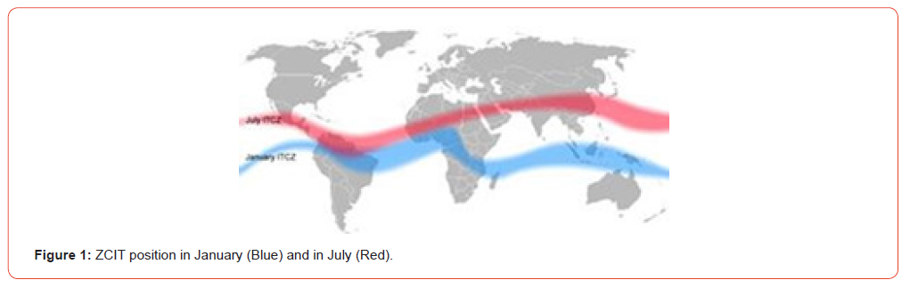
In climatology, the ITCZ corresponds to the meteorological equator (ME). Its variations have a significant effect on rainfall for many equatorial nations, producing dry seasons and wet seasons (monsoons). Prolonged anomalies in the ITCZ can produce extreme weather events in the intertropical zones. Calm or weak winds of variable direction are found in the lower layers of the atmosphere near the ITCZ. These equatorial calms follow, with a slight delay, the annual meridional shift. Climate change will cause the Intertropical Convergence Zone to shift northward. This shift is temporary (lasting about twenty years) but will have significant consequences for agriculture. The position and structure of the ITCZ vary depending on location and season. It is often extremely clear over the Atlantic Ocean, where it takes the form of a narrow and well-defined convergence line, along which a multitude of thunderstorms develop, whose “anvils” form an almost continuous cloud cover (Figure 1). Above the continents, it is marked by a band of intense convective activity which often remains broad and diffuse.
The Intertropical Convergence Zone in Africa (ITCZA)
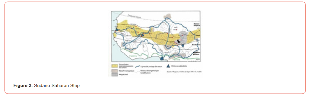
In West Africa, where the Intertropical Convergence Zone (ITCZA) varies from a centered position between 5°North in winter and 20°North in summer, which covers the Sahelian band and the equatorial band (Figure 2). During the boreal summer (June- September), the dynamics of West Africa are dominated by the northward movement of the West African monsoon, a mass of warm, humid air originating in the Atlantic. This flow encounters dry air from the Sahara (the Harmattan) at the Intertropical Convergence Zone (ITCZA), resulting in heavy rainfal.
Studies show that vegetation types are distributed along bands that correspond fairly precisely to the annual movement of the Intertropical Convergence Zone (ITCZ). In summer, large quantities of water vapor from the Gulf of Guinea are advected in the lower atmosphere by the trade winds (African monsoon flow) towards the ITCZ. Numerous thunderstorms develop more than 1,000 km south of the ITCZ in regions where the moist layer is quite thick. As one approaches the ITCZ, the moist layer becomes thinner, and convection is characterized mainly by the presence of 600- or 700-km-long convection bands (squall lines), oriented north-south, which propagate westward for one to two days and provide most of the rainfall associated with sub-Saharan regions. The immediate vicinity of the Intertropical Convergence Zone (ITCZ), due to the thin layer of moist air, very rarely receives precipitation. However, the position of the ITCZ is not the only factor governing the strength and frequency of convection. Indeed, no significant difference has been observed between the positions of the ITCZ during dry years and those observed during the wettest years.
African Monsoon Continental Tropical Convective System
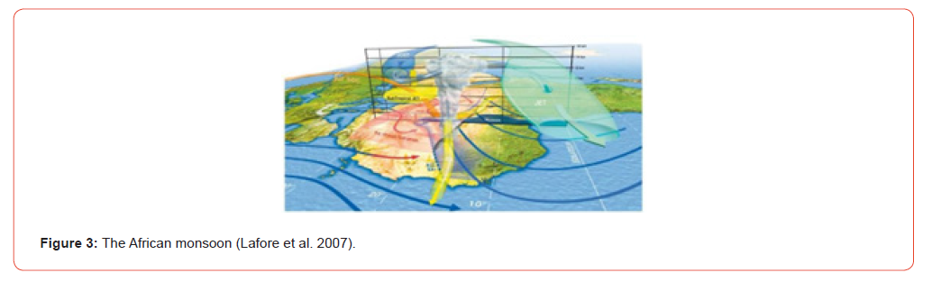
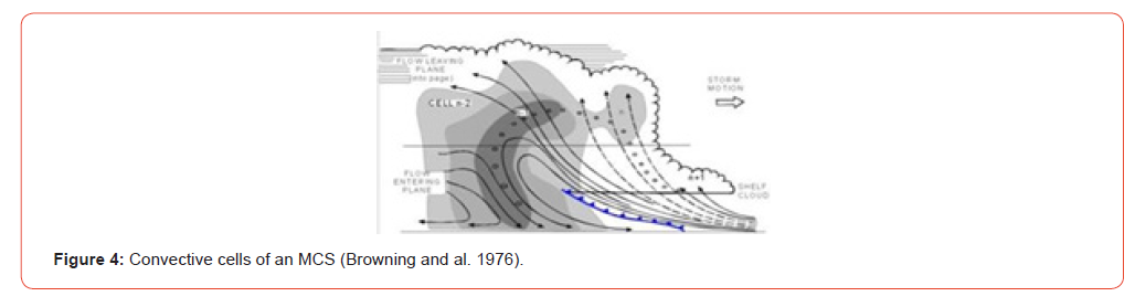
During the August 2010 campaign in Niamey, Niger, during the African monsoon season, the observed systems were formed from the interaction of different air masses (Figure 3). The northward movement of the ITCZ during the boreal summer creates a northward shift of the trade winds over the African continent. This monsoon flow (southwest) brings moisture from the ocean into the lower troposphere, where it meets the warmer, drier Harmattan flow (northeast) to create a convergence zone known as the Intertropical Front (ITF) [2,3]. At high altitudes, three jet streams maintain and influence the formation of convective systems: the African East Jet (AEJ; east-west at 650 hPa), the Tropical East Jet (TEJ; east-west at 150 hPa), and the Subtropical West Jet (JOST; west-east at 200 hPa) [4,5]. Low-level humidity combined with significant vertical and horizontal wind shear promotes the formation of cumulonimbus clouds [6]. Cumulonimbus clouds cluster in circular groups or lines (squall lines). A cold subsiding flow (density current) causes air masses to rise ahead of the system. A cold front forms, maintaining convection and renewing the convective parts of the system [7,8], while the old convective cells are located behind the system, thus creating the stratiform part (Figure 4). The MCS advances from east to west; when it is no longer fueled by convection, its stratiform part can persist for several more hours.
The Intertropical Convergence Zone over Guinea
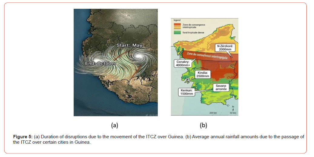
In Guinea, we observe that disturbances from the Intertropical Convergence Zone (ITCZ) are very early. They begin as early as the start of May and persist until the end of October, or even November; this results in a rainfall period of up to seven months (Figure 5a). The regions with the highest average rainfall are those located in the center of the ITCZ: Conakry with over 4000 mm; Kindia with 2500 mm; and Nzérékoré with 2000 mm. The Kankan region has an average rainfall of 1500 mm despite the presence of abundant vegetation (Figure 5b).
Maximum and minimum values are estimated from the typical interannual variability of the West African monsoon (coefficient of variation of 20-35%). Exceptionally wet years (e.g., 2012 with SPI > +2 in Boké) and dry years were taken into account. The methodology used is as follows:
a. Averages are calculated from reference climatological
data (primarily for the period 1991-2020);
b. For the period 2000-2025, the data follow observed
trends, including exceptionally wet years (2008, 2012) and
relatively dry years (2001, 2015);
c. Maximum values correspond to the wettest years of the
period (generally 130-150% of the average);
d. Minimum values correspond to the driest years (generally
50-70% of the average). - Variability is greater on the coast
(Conakry, Boké, Kindia) due to oceanic influence.
Based on Table 1 and the histogram (Figure 6), rainfall
distribution varies significantly, reaching a peak of 1143 mm (in
August) and less than 500 mm (in August) in Upper Guinea:
a. Conakry is the rainiest city (peak of 1143 mm in August);
b. Boké and Labé follow with peaks exceeding 500-550 mm
in August;
c. Siguiri and Kankan (Upper Guinea) receive the least
rainfall.
Rainfall peaks generally occur in July-August on the coast and in August-September in Forest Guinea.
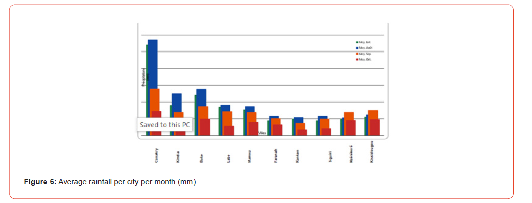
Table 1: Average rainfall in the main cities of Guinea (july –october) referenced period 2000-2025. Average rainfall in the cities of Guinea (July-October).
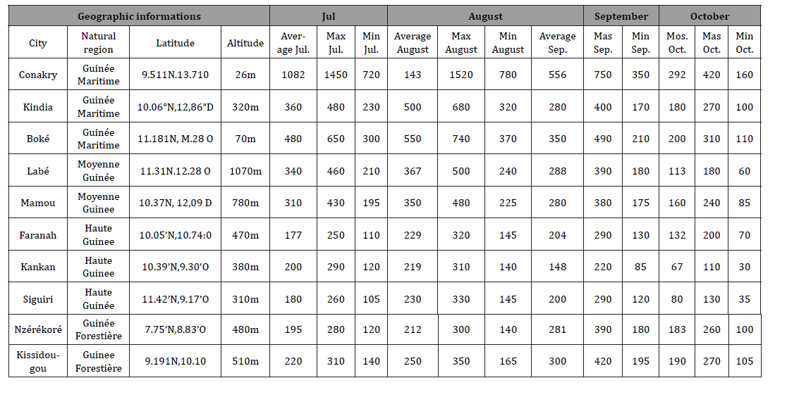
Reference period : 2000-2025| Precipitation in millimeters (mm).
Table 2: Comparative rainfall analysis by natural region. Monthly averages (mm) | from July to October | Period 2000-2025.
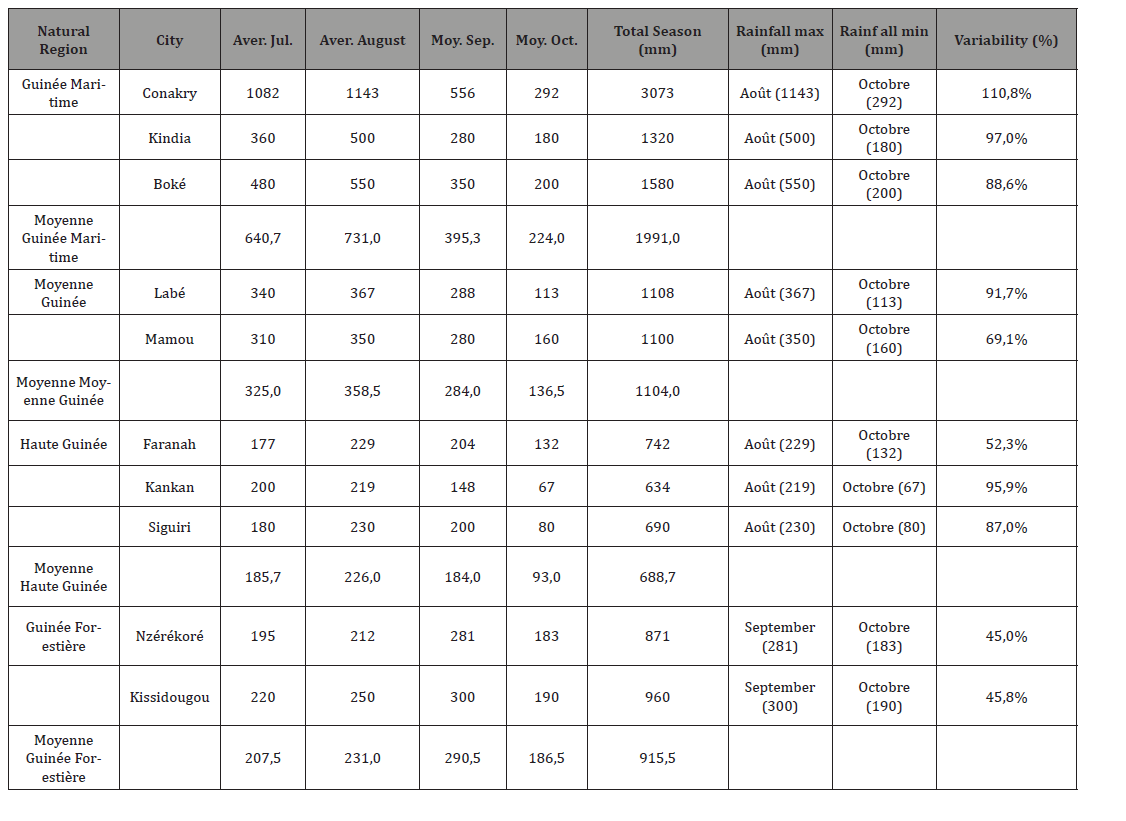
By comparing the amounts of rain with the natural region (Table 2), we find that, for the regions of Maritime Guinea (Conakry, Kindia and Boké), Middle Guinea (Labé and Mamou) and Upper Guinea (Faranah, Kankan and Siguiri), the maximum rainfall is reached in August and the minimum in October, whereas for Forest Guinea the maximums are in September.
Conclusion
The Intertropical Convergence Zone (ITCZ), or meteorological equator, is centered over Guinea for a considerable period, between six and seven months. This presence promotes favorable rainfall.
The spatial and temporal distribution of rainfall highlights four
natural regions:
a. Maritime Guinea: high coastal rainfall, peaking in July-
August (3000-4000 mm/year);
b. Middle Guinea: moderate to high rainfall, influenced by
altitude (2200-2800 mm/year);
c. Upper Guinea: lower rainfall, Sudanese climate (1500-
2000 mm/year);
d. Forest Guinea: more spread-out rainfall, later peak in
August-September (2200-2300 mm/year).
The regions near the coasts or those at higher altitudes receive abundant rainfall. We propose investigations to understand their contribution to rainfall in future study.
References
- Mamadou Thiam (2024) Couplage océan-atmosphère en Atlantique Tropical Nord-Est et impact sur les précipitations au Séné Planète et Univers [physics]. Sorbonne Université; Université Gaston Berger de Saint-Louis (Sénégal).
- Eltahir EAB, C Gong (1996) Dynamics of Wet and Dry Years in West Africa. Journal of Climate 9(5): 1030-1042.
- Serge Janicot, Benjamin Sultan (2001) Intra-seasonal modulation of convection in the West African Monsoon. Geophysical Research Letters.
- Andreas H Fink, Andreas Reiner (2003) Spatio-temporal variability of the relation between African Easterly Waves and West African Squall Lines in 1998 and 1999. Journal of Geophysical Research: Atmospheres 108(D11): 4332.
- Vincent Mathon, Henri Laurent, Thierry Lebel (2002) Mesoscale Convective System Rainfall in the Sahel. Journal of Applied Meteorology 41(11): 1081-1092.
- Houze Jr RA (2004) Mesoscale Convective Systems. Reviews of Geophysics 42: Article ID: RG4003.
- Jean Philippe Lafore, Mitchell W Moncrieff (1989) A Numerical Investigation of the Organization and Interaction of the Convective and Stratiform Regions of Tropical Squall Lines. Journal of the Atmospheric Sciences pp. 521-544.
- Lafore JP, Peyrillé P (2007) An Idealized Two-Dimensional Framework to Study the West African Monsoon. Part II: Large-Scale Advection and the Diurnal Cycle. Journal of the Atmospheric Sciences 64(8): 2783-2803.Data sources
- com Données mensuelles de précipitations pour Nzérékoré, Kankan, Labé, Faranah. Moyennes calculées sur la période disponible (données historiques récentes).
- com Données de précipitations mensuelles pour Conakry. Climatologie basée sur la période 1991-2020.
- climate-data.orgDonnées annuelles et mensuelles de pré Référence croisée pour Conakry et autres villes.
- SCIRP (2024) Article 'Analysis of Rainfall Dynamics in Conakry, Republic of Guinea'. Données de pointe pour Boké (~550 mm en août) et Kindia (~500 mm en août).
- MDPI Atmosphere Article 'Climate Dynamics in Guinea Under Global Warming'. Contexte général: 1200-1500 mm/an à l'intérieur, 4000 mm sur la cô
- ResearchGate (2020) Figure 'Mean seasonal cycle of rainfall by Guinea synoptic stations during 1981-2010'. Données pour Mamou (~400 mm/mois au pic).
- World Bank Climate Portal Climatologie (CRU) 1991-2020. Contexte national des pré
- weather-atlas.com Données pour Kindia: Juillet 360 mm, Août 436 mm, Septembre 254 mm.
-

This work is licensed under a Creative Commons Attribution-NonCommercial 4.0 International License.