

 Research Article
A Review of Utilizing Remotely Sensed GRACE Data for Integrated Water Management in CONUS River Basins
Received Date: December 21, 2024; Published Date: January 16, 2025
Abstract
The integration of Gravity Recovery and Climate Experiment (GRACE) satellite data with hydrological models could revolutionize integrated water management, particularly in the Contiguous United States (CONUS) river basins. GRACE’s ability to measure terrestrial water storage anomalies (TWSA) provides critical insights into groundwater and streamflow dynamics that traditional in-situ measurements cannot capture. When combined with hydrological models, GRACE data improves the accuracy of streamflow and groundwater recharge predictions, enabling better management strategies for diverse and complex river basins. However, GRACE’s low spatial resolution presents challenges, especially for smaller basins or regions with uneven topography. Addressing this limitation requires advanced downscaling techniques and integration with complementary datasets like remote sensing and in-situ measurements. Moreover, GRACE data, when coupled with climate change models, supports integrated water resource management by identifying long-term trends and vulnerabilities to climate change and human activities. This combined approach aids in developing adaptive strategies to sustain water availability for both ecological and human needs. Future research should focus on refining GRACE applications to enhance resolution and expand their use in managing smaller and more complex water systems. The study results are a valuable addition to understanding and prediction of water resources, thereby supporting sustainable water management practices in the face of climate change and human activities.
Keywords: GRACE, remote sensing, groundwater recharge, CONUS river basins, hydrological models, SWAT
Introduction
Hydrology, as a scientific discipline, encompasses the study of the occurrence, movement, distribution, and quality of water on Earth and other planets, with particular emphasis on the hydrological cycle, water resources, and watershed environmental sustainability. The significance of hydrological systems has become increasingly pronounced due to rapid urbanization and industrialization. These processes include deforestation, alterations in land cover, and irrigation practices, all of which, combined with chang es in climate and soil heterogeneity, have a direct impact on river discharges (Devi, Ganasri, & Dwarakish, 2015). Research focused on the Contiguous United States (CONUS), which comprises the 48 states of the U.S. along with the District of Columbia in central North America, has highlighted the need to prioritize the 511 river basins within this region (Figure 1). Such prioritization would facilitate more intensive monitoring and more accurate assessment of the area and its water resources (Balasubramanian & Nagaraju, 2017; [1-2].

Hydrological Responses in CONUS River Basins
Landscape Vulnerability
The assessment of landscape vulnerability in the CONUS river basin is critical. Landscape vulnerability refers to the extent to which a landscape is affected and unable to adapt to the impacts of climate change, primarily due to anthropogenic modifications [3-6]. Between 2001 and 2016, the CONUS landscape underwent significant transformations, including an 8% change in overall landscape, driven by alterations in land cover. Notably, nearly 50% of forest areas were affected, with declines attributed to harvesting, fires, diseases, and pest infestations [7]. During this period, agricultural lands expanded by 4,778 km², although pastures declined by 7.94%, with much of the transition occurring in crop cultivation. Additionally, water and wastewater management saw a 15.2% change, reflecting the highly dynamic nature of land cover. Groundwater resources in the CONUS river basin also experienced notable changes, with drought conditions adversely affecting vegetation [8]. The drying trends in the Southwest were largely due to a weakening of the North American monsoon and a decrease in precipitation [9]. A prominent example is the Colorado River Basin drought, which was triggered by low precipitation levels in the upper Colorado River basin and other headwater basins.
Climate Change Fluxes
Climate change significantly impacts water quality in river basins, affecting both groundwater and surface water which are critical components of water supply with direct implications for public health. Global warming and changes in precipitation patterns, both effects of climate change, threaten water supply and quality, thereby posing risks to human health through waterborne diseases and compromised hygiene standards [10]. Additionally, variations in water quality can influence crop yields and ecosystem health, which in turn affect the well-being of communities [11]. Climate change models enable the forecasting of the long-term effects of increased greenhouse gas emissions, projecting several centuries into the future based on the current understanding of atmospheric physics and chemistry. Presently, all General Circulation Models (GCMs) operate on a three-dimensional grid with a horizontal spatial resolution of 250 km -600 km and a vertical resolution comprising 10-20 layers in the atmosphere and approximately 30 layers in the ocean. In contrast, regional climate models offer greater detail, providing resolutions on the order of tens of kilometers. These models are specifically developed for regions and account for geographical features such as mountains, vegetation cover, and soil type, leading to more accurate predictions for those areas [12, 13].
Integrated Water Management
Integrated water management involves the complex and dynamic interaction between surface water and groundwater systems, a process that occurs on the Earth’s surface and is influenced by various factors, including geographical location and climate. This interaction is a critical aspect of water resource management, especially in the context of land use dynamics, climate change, and human activities [14-16] Understanding the spatial and temporal patterns between surface water and groundwater is essential for maintaining aquatic ecosystems [17]. Moreover, this interaction significantly impacts other human activities, such as the dispersion of pesticide metabolites into groundwater, the condition of lakes, water safety for public supply, and the effectiveness of irrigation schemes.
Groundwater plays a crucial role in sustaining river flows, supporting agricultural irrigation, and providing potable water for urban and rural communities. In CONUS, groundwater contributes significantly to the flow of major river systems, such as the Colorado, Mississippi, and Missouri rivers. Effective integrated water management ensures that these vital resources are managed sustainably, balancing the demands for water with the need to protect aquatic ecosystems [18]. The interconnectedness of surface water and groundwater in CONUS river basins underscores the importance of an integrated approach to water management. Groundwater recharge and discharge processes are closely linked to surface water systems, and changes in one can significantly impact the other. For example, variations in precipitation and land use can alter groundwater recharge rates, which in turn affects river baseflows and water availability for various uses [19].
Challenges and Adaptations
Integrated water management in CONUS faces several challenges, primarily related to the variability and complexity of groundwater systems. The diverse geology, hydrogeology, and climate across the CONUS region mean that groundwater systems exhibit significant spatial and temporal variability. This variability complicates the development of uniform management strategies and necessitates a nuanced understanding of local groundwater conditions [20]. Another challenge is the fragmentation of groundwater governance. In many regions of CONUS, groundwater management is governed by multiple agencies and stakeholders, each with different priorities and regulations. This fragmentation can lead to inefficiencies and conflicts, making it difficult to implement cohesive and effective management practices [21].
Climate change exacerbates the challenges of integrated water management by altering precipitation patterns, temperature, and evapotranspiration rates, all of which affect groundwater systems. In CONUS, climate change is predicted to lead to more frequent and severe droughts, which can reduce groundwater recharge and increase competition for water resources [22]. Additionally, rising temperatures can increase evaporation rates, further straining groundwater supplies. The effects of climate change on groundwater resources are evident in several CONUS river basins. For instance, the Colorado River Basin has experienced prolonged drought conditions, leading to significant declines in groundwater levels and reduced river flows [23]. Similarly, the Mississippi River Basin has faced challenges related to altered precipitation patterns and increased runoff, impacting groundwater recharge and water quality [24]. Recent advances in technology and modeling have enhanced the ability to manage groundwater resources more effectively. Remote sensing, groundwater modeling, and hydro informatics have provided new tools for monitoring and assessing groundwater systems. For example, satellite-based observations and groundwater models can improve the accuracy of assessments and help identify areas at risk of over-extraction or contamination [25]. Integrated water management strategies are increasingly incorporating climate change projections to anticipate and mitigate potential impacts. These strategies involve using climate models to predict changes in precipitation and temperature and to assess their effects on groundwater recharge and discharge [26]. Additionally, stakeholder engagement and collaborative approaches are essential for developing effective management plans that address local needs and conditions [27].
Utilization of Remote Sensing and Geospatial Technology
Remote sensing (RS) and geospatial technologies play pivotal roles in assessing, developing, and planning water resources, particularly in the context of integrated water management in CONUS river basins. RS technology enables the acquisition of information about various objects from a distance, providing valuable data for water quality assessment and other water resources management activities. Satellite-based RS techniques have been extensively established and are increasingly employed to monitor and manage water resources effectively [28]. Geographic Information Systems (GIS) have advanced rapidly, necessitating the development of new methods and solutions to enhance data processing and integrate complex environmental simulation models [29-31]. Modern GIS systems leverage a variety of data acquisition methods, including internet sources, Global Positioning System (GPS), and RS technologies, to address the challenges of integrating diverse and intricate environmental data [32].
Advancements in RS and GIS models facilitate a comprehensive investigation of hydrological cycles, including the spatial and temporal distribution of meteorological parameters and the quantification of water balance components. RS contributes to groundwater resource management through quantitative assessments, geometric evaluations, and the development of correlations among various hydrological variables [33]. GIS systems are designed to collect, store, integrate, and analyze geographic data, and they include maps that represent river networks and river basins, thereby enhancing our understanding and management of groundwater resources [34].
GRACE Data in Estimation of Water Responses
Satellite remote sensing and GIS models complement traditional watershed modeling, though they are subjected to spatial and temporal discontinuities. For instance, while local systems like TerraSAR- X (TSX) offer detailed observations, NASA’s Gravity Recovery and Climate Experiment (GRACE) satellites have proven invaluable for estimating monthly changes in groundwater storage across large aquifer systems globally. Since their launch in March 2002, the GRACE satellites have significantly contributed to assessing terrestrial water storage anomalies on both regional and global scales.
The data from GRACE enables the determination of temporal changes in Earth’s gravity field, which is used to estimate variations in surface water storage [35]. By integrating information from hydrological models and in-situ measurements, scientists can analyze groundwater storage anomalies (GWSA) using GRACE data. This method has been effective in estimating monthly freshwater discharge and understanding terrestrial water storage, subsurface water, and groundwater, particularly in the Columbia River Basin [36]. The utilization of GRACE datasets has proven instrumental in evaluating watershed runoff and improving our understanding of various components of the hydrological cycle.
Several studies using GRACE datasets helped estimate the outflow of river basins by monitoring freshwater discharge to enhance understanding of water resource management (Gemitzi, Koutsias, & Lakshmi, 2021). Nevertheless, there are some drawbacks to using GRACE datasets, including the issue of low spatial resolution [37]. The biggest challenges of GRACE, being its coarse spatial resolution, is derived through mass change fields which is controlled by two factors: the availability of having limited degree and order due to the SH coefficient and the attenuation effects that happen due to spatial filtering and smoothing. The leakage biases can be reduced by quantifying the mass variation at basins and at regional scales using the time-variable gravity solution [38] Nerem et al., 2018. The challenge for GRACE data also relates to having a low degree of spherical harmonic coefficient (SH-coefficient) due to Geocenter. The motion in geocentres does affect GRACE data due to changes in estimation, which can be tackled effectively using different methods to estimate the motion of geocentres.
GRACE datasets are used in various types of hydrological applications. One of the largest uses of the GRACE data is, therefore, in the determination of TWSA change, which is the total amount of surface water, soil water, recharge, and snow [36]. The pilot studies indicated that short-wave noise and leakage errors must be assimilated into computations to obtain an accurate assessment of TWSA from GRACE data. It also demonstrated that one can bring a higher temporal as well as spatial accuracy to the TWSA as it is obtained by means of GRACE during contrasting phases of the year. The GRACE dataset is also used to evaluate hydrological components such as groundwater storage, soil moisture, and evapotranspiration which have also been evaluated with the help of data derived from the GRACE (Jiang, Wang, Yaohuan Huang, & Xiangyi Ding, 2014, [39]. It can also be used to analyze droughts. In effect, relative to water storage seen by GRACE, anomalies of water deficit can pinpoint regional and seasonal characteristics that are pivotal in the definition of droughts and the extent of their occurrence (Jiang, Wang, Yaohuan Huang, & Xiangyi Ding, 2014). The use of GRACE datasets helps develop a data-driven hydrological model. The datasets help provide accurate large-scale measurements with streamflow and groundwater recharge estimation in the CONUS river basins. The datasets help to improve the accuracy of stream flow and groundwater recharge estimation.
Enhanced Hydrological Modeling Possibilities with GRACE

The integration of GRACE data into hydrological models enhances the estimation of streamflow and groundwater recharge by providing precise measurements of terrestrial water storage anomalies. GRACE satellites, which measure changes in Earth’s gravity field, offer valuable data for understanding the temporal dynamics of groundwater storage and streamflow across large regions. This enhanced capability is crucial for improving water resource management and addressing challenges related to water availability and quality [40, 35, 36]. By incorporating GRACE data, hydrological models can more accurately capture the interactions between groundwater and surface water, leading to more informed decision- making in water resource management.
The water quality models that were used in CONUS included the Hydrologic and Water Quality System (HAWQS). The model is built on the Soil and Water Assessment Tool (SWAT), which helped advance its functionality and minimize the necessary time for initiation (Figure 2). It helps improve and ensure national case analysis eases its application. The basic subsystems of the model are the hydrological, climatic, erosive, thermic, vegetative, nutritional, pesticide, and managerial subsystems [38]. The SWAT model is physically based and semi-distributed. The model helps towards stimulating the hydrological process to ensure water balance and stream flow.
The equation that is used for the SWAT hydrological model is as follows:
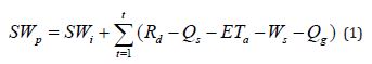
Each grid cell above the reservoir contains the baseflow and discharge simulated data for the routing model, as seen in the image [38]. Water must be transported to the reservoir, and the estimated discharge must then be modified utilizing the pre-impoundment streamflow data that is now available. There were two parts to the research integration of the models for the period. It also determined a variation period and a baseline period to evaluate the yearly mean runoff changes. The technique was not limited to estimating the effects of climate change on streamflow and long-term water balance in hydrology. The GRACE SWAT modeling study by [38] highlighted the need to determine the entire hydrological response to conditions brought on by climate change as a requisite for larger river basins.
Some shreds of literature employed inverse weighted method for spatial downscaling in GRACE-SWAT modelling approach. Presently, there are two main downscaling approaches that include the physical-based downscaling method and the use of statistical downscaling. Physical-based downscaling or dynamical downscaling is based on a physical model that is established between the coarse-resolution variable and fine-resolution auxiliary variables. In statistical downscaling, a statistical relationship is established. One of the downscaling methods that can be used for statistical downscaling is the use of thermal inertia or the use of vegetation and surface temperature (Gemitzi, Koutsias, & Lakshmi, 2021). SWAT is useful in evaluating the effects that result from variations in managerial practices in river basins from the perspectives of quantity, that of quality of water, sediment, and of chemicals. Integration of the obtained study results with the SWAT model combined with the Soil Moisture (SM) data assists in providing a better estimation of the hydrological processes [41-43]. It is through such integration that it enhances the depiction of the real water environment. The integration helps to take note of concerns about the soil moisture conditions that play a crucial role in defining streamflow, evapotranspiration, and groundwater recharge. [44, 45]. SWAT and SM combination enhances the management of the water resource as it provides more details on the water resources available and changes in the water resource. Such models are applied in an integrated manner to support the rational use of water resources and resolve the issues related to climate change and people’s impact.
Challenges and Future Directions
Limitations of GRACE Data in CONUS River Systems
While GRACE data has significantly advanced our understanding of water resources, its low spatial resolution poses challenges for its application in large river basins. Addressing these limitations through improved downscaling techniques and integrating GRACE data with other datasets is crucial for enhancing its utility in hydrological modeling.
Advancements in Hydrological Modeling
Future research should focus on improving the integration of GRACE data with hydrological models and developing new methods for overcoming spatial resolution challenges. Additionally, expanding the application of GRACE data to other regions and incorporating it into more comprehensive water resource management strategies will be essential for addressing global water challenges.
Conclusion
The integration of remotely sensed GRACE data with hydrological models like SWAT has proven to be a transformative approach in advancing our understanding and management of water resources, particularly in the context of the Contiguous United States (CONUS) river basins. This review underscores several key findings and implications for future research and practical applications in water resource management. Firstly, the utilization of GRACE data provides significant advantages in monitoring large-scale hydrological processes. GRACE’s ability to measure terrestrial water storage anomalies (TWSA) offers a unique perspective on groundwater storage and streamflow that traditional in-situ measurements alone cannot achieve. This capability is particularly valuable in regions where groundwater is a critical resource, yet difficult to monitor comprehensively due to limited observational data. Secondly, the inte gration of GRACE data with hydrological models such as SWAT enhances the accuracy and reliability of streamflow and groundwater recharge estimations. By incorporating GRACE’s large-scale observational data, these models can better account for the spatial and temporal variability in water resources, leading to more informed predictions and management strategies. This is crucial for the CONUS river basins, where diverse climatic and geological conditions necessitate robust modeling approaches to address the challenges posed by climate change and human activities.
However, the review also highlights the limitations of GRACE data, particularly its low spatial resolution, which can be a significant drawback when applying it to smaller river basins or regions with complex topography. This limitation necessitates the development of advanced downscaling techniques and the integration of complementary datasets, such as those derived from remote sensing and in-situ measurements, to improve the granularity of water resource assessments. Moreover, the review emphasizes the importance of integrated water management in mitigating the impacts of climate change and anthropogenic activities on water resources. The use of GRACE data in conjunction with climate change models and integrated water resource management strategies can provide a more comprehensive understanding of the long-term trends and vulnerabilities of the CONUS river basins. This approach is essential for developing adaptive management practices that can sustain water availability for both ecological and human needs.
In conclusion, the combination of GRACE data with hydrological models represents a significant advancement in the field of water resource management. While challenges remain, particularly in terms of spatial resolution and data integration, the potential benefits of this approach are substantial. Future research should focus on refining downscaling methods, improving model integration, and expanding the application of GRACE data to smaller and more complex river basins. By doing so, we can enhance our ability to manage water resources sustainably in the face of ongoing environmental changes.
Acknowledgement
Funding for this project was provided in part by the National Science Foundation Grants OIA 2019561 and A20-0473-S006.
Conflicts of Interest
None.
References
- Prein AF, Holland GJ, Rasmussen RM, Clark MP, Tye MR (2016) Running dry: The U.S. Southwest’s drift. Geophysical Research letters.
- Preetha P, Hasan M (2023) Scrutinizing the Hydrological Responses of Chennai, India Using Coupled SWAT-FEM Model under Land Use Land Cover and Climate Change Scenarios. Land 12(5): 938.
- Preetha PP, Al-Hamdan AZ (2019) Multi-level pedotransfer modification functions of the USLE-K factor for annual soil erodibility estimation of mixed landscapes. Model Earth Syst Environ 5: 767-779.
- Preetha PP, Al-Hamdan AZ, Anderson MD (2019) Assessment of climate variability and short term land use land cover change effects on water quality of Cahaba river basin. Int J Hydrol Sci Technol 11: 54.
- Joseph N, Preetha PP, Narasimhan B (2021) Assessment of environmental flow requirements using a coupled surface water groundwater model and a flow health tool: A case study of Son river in the Ganga basin. Ecological Indicators 121: 107110.
- Snyder SD, SC Loftin, Reeve AS (2024) Vulnerability Assessment of Groundwater Influenced Ecosystems in the Northeastern United States. Water pp. 1-23.
- Homer C, Dewitz J, Jin S, Xian G, Costello C, et al. (2020) Conterminous United States land cover change patterns 2001-2016 from the 2016 National Land Cover Database. ISPRS Journal of Photogrammetry and Remote Sensing pp. 184-199.
- Metre PC, Qi S, Deacon J, Dieter C, Driscoll JM, et al. (2020) Prioritizing river basins for intensive monitoring and assessment by the US Geological Survey. Environ Monit Assess pp. 1-17.
- Sui L, Cao Q, Xiao M, David M, Mocko MB, et al. (2021) Drought Variability over the Conterminous United States for the Past Century. Journal of Hydrometeorology pp. 1153- 1168.
- Santos O, Virgolino A, RR Santos JC, Vaz-Carneiro A (2019) Environmental Health: An overview on the Evolution of the Concept and its Definations. Encyclopedia of Environmental Health PP. 460-474.
- Preetha PP, Johns M (2022) A review of recent water quality assessments in watersheds of southeastern United States using continuous time models. Global J Eng Sci 9: 1-4.
- Deresse T (2023) Climate Change Modeling. A Systematic Review. SSRN.
- Lutz AS, Maat H, Biemans H, Shrestha AB, Immerzeel WW (2016) The role of integrated models in predicting the effects of climate change on groundwater resources. Climate Dynamics 47(7-8): 2513-2528.
- Wang H, Jiao Y, BX, Fulin (2023) Study on Interaction between Surface Water and Groundwater in Typical Reach of Xiaoqing River Based on WEP-L Model. Water.
- Jakeman AJ, Barreteau O, Hunt RJ, Rinaudo JD, Ross A (2016) Integrated Groundwater Management: An Overview of Concepts and Challenges.
- Preetha PP, Maclin K (2023) Evaluation of Hydrogeological Models and Big Data for Quantifying Groundwater Use in Regional River Systems. In Environmental Processes and Management: Tools and Practices for Groundwater pp. 189-206.
- Liu C, Liu J, Hu Y, Zhengi C (2015) Studying groundwater and surface water interactions using airborne remote sensing in Heihe River basin, northwest China. Remote Sensing and GIS for Hydrology and Water Resources pp. 368-361.
- Gleeson T, Cuthbert MO, Ferguson G, Perrone D (2020) Global groundwater sustainability, resources, and systems in the Anthropocene. Annual Review of Earth and Planetary Sciences 48: 431-463.
- Baker B, Li X, Clark M (2022) Evaluating the impact of groundwater-surface water interactions on river basin water management. Water Resources Research 58(4): e2021WR031123.
- Scanlon BR, Faunt CC, Long JCS, Alley WM (2012) Groundwater availability and use: The contribution of groundwater to water supply and the impacts of climate change. Water Resources Research 48(6): W06519.
- Maddock T, Perrotta K, Scibek J (2020) Challenges in managing groundwater resources: Case studies from the CONUS region. Groundwater 58(4): 555-568.
- Milly PCD, Wetherald RT, Dunne KA, Del Sole R (2015) Increasing risk of great American droughts. Science 303(5665): 85-87.
- Katz BG, O’Driscoll MA, Jurgens BC (2020) Drought and groundwater depletion in the Colorado River Basin: Implications for water management. Journal of Hydrology 589: 125212.
- Hamilton SK, Morris JA, Thomas R (2019) Climate change impacts on groundwater and surface water interactions in the Mississippi River Basin. Hydrological Processes 33(15) 2325-2341.
- Famiglietti JS (2014) The global groundwater crisis. Nature Climate Change 4(11): 945-948.
- Lutz AF, Maat HW, Biemans H, Arun B, Shrestha PW, et al. (2016) Selecting representative climate models for climate change impact studies: an advanced envelope-based selection approach. International Journal of Climatology.
- Jakeman AJ, Barreteau O, Hunt RJ, Rinaudo JD, Ross A (2016) Integrated groundwater management. Concepts, approaches, and challenges.
- Ahmed W, Mohammed S, El-Shazly A, Morsy S (2023) Tigris River water surface quality monitoring using remote sensing data and GIS techniques. The Egyptian Journal of Remote Sensing and Space Sciences pp. 816-825.
- Ashraf Z Al-Hamdan, Pooja P Preetha, Mohammad Z Al-Hamdan, William L Crosson, et al. (2018a) Reconnoitering the linkage between cardiovascular disease mortality and long-term exposures to outdoor environmental factors in the USA using remotely sensed data. Journal of Environmental Science and Health 53(9): 809-818.
- Al-Hamdan AZ, Preetha PP, Albashaireh RN, Mohammad Z Al-Hamdan, William L Crosson (2018b) Investigating the effects of environmental factors on autism spectrum disorder in the USA using remotely sensed data. Environ Sci Pollut Res 25(8): 7924-7936.
- Preetha PP, Shirani-bidabadi N, Al-Hamdan AZ (2021b) A Methodical Assessment of Floodplains in Mixed Land Covers Encompassing Bridges in Alabama State: Implications of Spatial Land Cover Characteristics on Flood Vulnerability. Water Resour Manage 35: 1603-1618.
- Dandge KP, Patil SS (2022) Spatial distribution of groundwater quality index using remote sensing and GIS techniques. Appl Water Sci.
- Zakwan M, Wahid A, Naizkar M, Chatterjee U (2022) Water Resource Modelling and Computation technologies. Elsevier.
- Dongare P, Sharma KV, Kumar V, Mathew A (2024) Water distribution system modelling of GIS-remote sensing and EPANET for the integrated efficient design. Journal of Hydroinformatics.
- Yin W, Zhang G, Liu F, Zhang D, Zhang X, Chen S (2022) Improving the spatial resolution of GRACE-based groundwater storage estimates using a machine learning algorithm and hydrological model. Hydrogeology Journal pp. 947-963.
- Lia Q, Zhong B, Luo Z, Yao C (2016) GRACE-based estimates of water discharge over the Yellow River basin. Geodesy and Geodynamics pp. 1-7.
- Rahaman MM, Thakur B, Kalra A, Ahmad S (2019) Modeling of GRACE-Derived Groundwater Information in the Colorado River Basin. Hydrology pp.1-19.
- Touseef M, Chen L, Chen H, Gabriel HF, Yang W, Mubeen A (2023) Enhancing Streamflow Modeling by Integrating GRACE Data and Shared Socio-Economic Pathways (SSPs) with SWAT in Hongshui River Basin, China. Remote Sensing pp. 1-25.
- Preetha PP, Al-Hamdan AZ (2020a) Developing Nitrate-Nitrogen Transport Models using Remotely-Sensed Geospatial Data of Soil Moisture Profiles and Wet Depositions. J Environ Sci Health Part A 55: 615-628.
- Preetha PP, Joseph N, Narasimhan B (2021a) Quantifying Surface Water and Groundwater Interactions using a Coupled SWAT_FEM Model. Implications of Management Practices on Hydrological Processes in Irrigated River Basins. Water Resour Manage 35: 2781-2797.
- Preetha PP, Al-Hamdan AZ (2020b) Integrating finite-element-model and remote-sensing data into SWAT to estimate transit times of nitrate in groundwater. Hydrogeology Journal.
- Preetha PP, Al-Hamdan AZ (2022a) A union of dynamic hydrological modelling and satellite remotely-sensed data for spatiotemporal assessment of sediment yields. Remote Sens 14: 400.
- Preetha PP, Al-Hamdan AZ (2022b) Synergy of remotely sensed data in spatiotemporal dynamic modeling of the crop and cover management factor. Pedosphere 32: 381-392.
- Abbasi Y, Mannaerts CM, Makau W (2019) Modeling Pesticide and Sediment Transport in the Malewa River Basin (Kenya) Using SWAT. Water pp. 1-20.
- Gonzalez MO, Preetha P, Kumar M, Clement TP (2023) Comparison of data-driven groundwater recharge estimates with a process-based model for a river basin in the southeastern USA. Journal of Hydrologic Engineering 28(7): 04023019.
- Alexander RB, Schwarz GE, Boyer EW (2019) Advances in Quantifying Streamflow Variability Across Continental Scales: 1. Identifying Natural and Anthropogenic Controlling Factors in the USA Using a Spatially Explicit Modeling Method. Water Resources Research pp. 10893-10917.
- Gotzinger J, Barthel R, Jagelke J, Bardossy A (2008) The role of groundwater recharge and baseflow in integrated models. Groundwater-Surface Water Interaction: Process Understanding, Conceptualization and Modelling pp. 103- 109.
- Hamdi Mohamed, Kalifa Goïta (2023) Analysis of groundwater depletion in the saskatchewan river basin in canada from coupled SWAT-MODFLOW and satellite gravimetry. Hydrology 10(9): 188.
- Santhi C, Kannan N, White M, Luzio MD, JG Arnold, et al. (2014). An Integrated Modeling Approach for Estimating the Water Quality Benefits of Conservation Practices at the River Basin Scale. Journal of Environmental Quality pp. 177-198.
- Zhang Ying, Hou Jinliang, Gu Juan, Huang Chunlin, Li Xin (2017) SWAT‐based hydrological data assimilation system (SWAT‐HDAS): Description and case application to river basin‐scale hydrological predictions. Journal of Advances in Modeling Earth Systems 9(8): 2863-2882.
-

This work is licensed under a Creative Commons Attribution-NonCommercial 4.0 International License.


