 Research Article
Indepth Analysis of Channel Dynamics and Hydraulic Geometry in Anyang Sub-Catchment, Kwa Iboe River Basin, Nigeria
Jimmy UJ1*, Abraham CM1, Osogi MA1 and Chrysoula Pantsi2
1Department of Geography and Natural Resources Management, University of Uyo, Nigeria
2Edinburg Napier University. School of Engineering and the Built Environment, UK
Jimmy UJ, Department of Geography and Natural Resources Management, University of Uyo, Nigeria.
Received Date:May 17, 2025; Published Date:June 27, 2025
Abstract
The study sought to evaluate the hydraulic characteristics of the Kwa Iboe River Basin, one of the largest river basin in Niger Delta region, Nigeria, in an attempt to relate changes in channel parameters like width, depth, velocity and discharge, cross section profile of the river and determine its hydraulic geometry relations. Experimental research design was used since the study was based on physical parameters with quantifiable attributes. Some relevant equipment and measuring tools as used during field measurement were Global Positioning System (GPS), meter rule, stop watch, linen tape, float, digital camera, rope. Descriptive analysis was considered in the study and involved computation of mean, total, range, coefficient of variation, standard deviation, charts and tables. To analyse data gathered from the field, correlation and regression statistics were employed. The relationship between the discharge values and the hydraulic geometry parameters of the Anyang River has been developed by employing the linear regression analysis procedure. The average velocity of the stream flow, the water surface width and the average depth of the river are the parameters which were related to the river flow discharge. The Pearson Product Moment correlation was to explain the nature of the relationship between variables (channel width and discharge, depth and discharge and velocity and discharge). Based on the findings of the study, it was revealed that the channel features are similar to those river sections located along the river source characterized by high discharge and velocity, and narrow channel width The hydraulic geometry of the river did not conform or was not identical with that of most regions studied. It therefore shows that every river channel has unique characteristics which is best studied independently. As such, it was suggested that regular studies of river characteristics should be made in order to allow for availability of river parameters data and also river monitoring system should be made to understand the factors that are responsible for channel modifications.
Keywords: Oil spill; Weathering processes; OpenOil; WRF; Saronic Gulf; Numerical simulations
Introduction
River morphology has been a subject of great challenge to scientists and engineers mostly because the morphology of any river shows great variability and dynamic behaviour [1]. In developed countries, especially in the United States of America, Britain and Europe, large scale river studies have been conducted with the most pronounced being that of Leopold and Maddock which was conducted throughout the western region of USA [2-3] The availability of information from such studies have been found to be one of the key factors of success in river management in such countries. In the developing countries, especially in Africa this is not the case. There is a great dearth in studies in this area and until recently, river morphology studies were minimal [1]. [4] posited that characteristics of rivers vary spatially and temporally from one climatic, geologic, hydrologic region to another. Furthermore [5], has it that the tropical streams exhibit unique features that vary from their temperate counterparts. Due to this variability, there exist no generally acceptable characteristic feature of river morphology to fit different rivers even if they exist within the same climatic, geologic and hydrologic condition and even along the same reach. Thus, this research seeks to study uniquely, the channel dynamics of Anyang River in order to provide knowledge of how the various influences (natural or man-made) acting within channel bed and boundaries shape the channel form. This research aims to investigate the channel dynamics and Hydraulic Geometry of Anyang Sub-Catchment, Kwa Iboe River basin. This will be achieved through the study of the river hydraulic characteristics, establishing the channel parameters relations and characteristics and examining the channel discharge and channel width, channel velocity, channel depth,
Literature Review
The growing population of human pose a great threat to river systems at different scales as the dependence of humans on large rivers is bound to increase, resulting in the disturbance of the river system through such activities as diversion of urban storm water into streams, water abstraction for irrigation, pollution through industrial and urban expansion as well as reduction in connectivity and alteration of hydrologic regime by construction of dams, barrages and related engineering structures [6].
The perceived threat on these complex systems has incited scholars from different fields worldwide to carry out studies on areas such as controls of river development [7], morphology of rivers [8], hydraulic geometry [9-11, 5]. However, these studies are not challenge free because of the complex relationship between variables that determine river channel morphology.
A river or stream channel often described as the physical confines of a stream with a channel bed and defined banks is modified by flow and sediment and standing or entrenched wood in it. Sediment supply to a river is primarily due to the potential of the river to erode its boundary, scour its bed and transport material which have been brought from upstream. Channel dimensions such as channel width, depth, velocity adjust to this process through erosion and deposition to attain a dynamic equilibrium [1] or remain in a perpetual state of flux and constantly adapt to recent flood and changing sediment load. A reduction in sediment supply through revetment construction for example causes change in channel characteristics of these dimensions and concomitant adjustment in river cross section planform (geometry), channel configuration, longitudinal profile of river etc. This complex interrelationship between channel dynamics and discharge is termed hydraulic geometry [12].
According to [10], hydraulic geometry connotes the relationship between the mean stream channel form and the discharge both at a station, and downstream along a stream network in a hydrological homogeneous basin. It is a term used to describe the quantitative measurement of some of the hydraulic factors that help to determine the shape (width, depth, velocity, and suspended load) of natural streams and how they vary with discharge as a simple power function. The power function represented by [9] asw = aQb, d = cQf and v = kQm with w, d, v being wetted channel top width, mean depth, and velocity respectively and a, c, k, b, f, m are numerical constants are examined to how a stream channel adjusts and accommodate gains of water and sediments with increase in discharge [5].
Overtime, rivers develop a dynamic equilibrium between their channel and normal flow [13]. The form of this channel affects the flow of water in it and, through erosion and deposition, the flow modifies the form. Channel dimensions adjust through erosion and deposition thus shaping the river cross-section. In addition to the adjustment in cross-sectional area, the geometry and profile (longitudinal profile/slope) characteristics of a river also adjust to changing water and sediment inputs such that alterations in the natural flow regime of any river or stream can result in adjustment to the overall planform (geometry), cross-sectional channel geometry, bed configuration and channel bed [14]. Furthermore [15], listed the geomorphic parameters driving the longitudinal pattern of channel geometry as alternating degree of channel confinement, tributary inputs, colluvial inputs (landslide), differential substrate erodibility, spatial gradient and discontinuities imposed by quaternary tectonic and landscape evolution.
The morphometric features of the channel resulting from different forcings determine the type of channel (straight meandered, braided, wandering) and its evolution based on the sinuosity and multiplicity degree of the channel [16].
[17] in his study of stream classification identified factors that can influence channel morphology and conclude channel with bedrock have limited sediment supply whereas cobble and gravel bed channels are high energy channels with high sediment supply. Therefore, erosion instability mass wasting and debris flow are more dominant processes as the bed materials become finer and this effect channel morphology.
[16] used the sinuosity and multiplicity approach to determine characteristics of multiple channel pattern and suggested that, if the alluvial bars separating the channel lack of vegetation, the channel is considered active and is typical of braiding and wandering pattern and asserted that morphology of river valley results from the genetic and dynamic characteristics imposed by geologic factors such as tectonic, lithology as well as control variables related to the external morphogen environment such as climate, vegetation, relief, soil, land use, sediment load and sediment flow.
[17] showed that depth would increase faster than width in a rectangular channel, but in a more triangular channel width may increase faster than depth. The Variation in velocity with depth is related to frictional characteristics. In a channel where increasing flow depth quickly drowns out the effects of roughness elements, velocity would increase quickly with depth, and therefore proposed that a channel dominated by grain resistance would have the highest rates of decrease in resistance as discharge increases.
In a study by [18], it was postulated that the gradient and average roughness-area were found to be significantly related, indicating that both driving and resisting forces influence the rates of change of velocity, depth and width with discharge. Further analysis of the exponents showed that reaches with m > b + f are most likely dominated by grain resistance and reaches below this value (m < b + f) are dominated by form resistance.
The researcher used at-a-station hydraulic geometry to study controls of steep headwater streams in Colorado, USA and had the following results. The at-a-station values showed m > f > b (that is velocity greater than width and depth), indicating that the rate of change of velocity with discharge is greater than the rate of change of width or depth, indicating that the velocity is increasing faster than the flow area in these reaches. Because banks are strong, resist erosion and can stand nearly vertical, and depth is sometimes constrained, adjustment in discharge is accommodated largely by changes in velocity. The results obtained by the study of hydraulic geometry of steep channels showed that b, f, m, representing channel width, depth and velocity respectively had values ranging from 0.06,0.35 and 0.60 respectively [19]. According to the result, with changing at-a-station discharge, rapid changes in velocity are accompanied by moderate changes in depth and almost no change in width.
The width exponent signifies that there is not a large variation in width between low and high flows for a majority of the reaches despite changes in some reaches because of bank undercutting. Differences in the rate of change of depth and width with discharge may be related to differences in channel shape and roughness. Where m > f, it can be interpreted as increasing stream competence with increasing discharge. In cases where b being higher than f’(b>f), indicates that erosion of the banks occurred at a faster rate than that of the bed to accommodate increasing discharge, and it is also an indication of non-cohesive bank material [20]. The range in b values of 0.3-0.5 for bedrock channels is broader than that for the classic discharge-width relation for alluvial channels (i.e. b, =0.5). The concept of hydraulic geometry was formed as a remodelling of the Regime theory of Lancey. Hydraulic geometry involves the quantitative description of the channel cross section size and shape, fluid flow properties and sediment transport characteristics, in relation to the discharge being conveyed by the channel [21,22]. The adjustment of channel morphology and hydraulics in response to change in discharge has been considered in two different contexts namely; at- a- station hydraulic geometry and downstream hydraulic geometry.
At-a-station hydraulic geometry describes how channel geometry and flow hydraulics change as discharge increases at an individual cross section over time. In other words, at-astation hydraulic geometry describes how increase in discharge is accommodated and depend entirely on the channel shape and the resistance to flow. Thus, the dynamics of river (erosion, transport and deposition) are assumed to be static.
Downstream hydraulic geometry describes how spatially increasing discharge enlarges and shapes the channel and alter stream flow properties in the downstream direction of the river. The downstream hydraulic geometry is determined by the way in which self-forming (alluvial) river systems are established and maintained via erosion, transport and deposition of sediments by the water flowing through the system. In downstream hydraulic geometry, channel geometry is assumed to be the result of the dynamic equilibrium established between the channel morphology and the formative discharge (a single discharge that over a long period of time would theoretically produce the same channel geometry as the natural long-term hydrograph). [9] represented the hydraulic geometry relation as a power function equation.
The equations are as follows:
W = aQb (1)
d = cQf (2)
v = kQm (3)
The variables w, d, and v are the parameters width, mean depth, and mean velocity, respectively. The coefficients or intercepts are represented by a, c, and k. The exponents or slopes are represented by b, f, and m.
Based on the continuity equation where Q = (w) (d) (v), the product of the respective coefficients (a) (c) (k) equals one, and the sum of the exponents (b + f + m) equals one [23].
Knowledge of the interrelationship between channel form and hydraulic variables are of great practical value in flood hazard management, water resource planning, prediction of channel deformation, design of stable canals and intakes, irrigation and river improvement work [24, 25]. It is on this basis that the present research is carried out in Anyang River a 3rd order tributary of Kwa Iboe River basin, to measure channel parameter characteristics of river, to determine the hydraulic geometry of the river.
Materials and Methods
The type of research design used for the present study is the experimental research design. This design was used because it enabled collection of relevant data relating to the objectives of the study which involve quantitative measurement of relationship between parameters to be obtained since the study is based on physical parameters with quantifiable attributes.
As experimental research, the present study makes use of quantitative data in order to yield the most productive result relevant to the problem at hand. As such, the data for this research was obtained from both on field measurement by the researcher and from the exhaustive study of previous works by researchers relating to the study. Thus, two types of data sources were used namely;
The primary source of data for the study includes the use of equipment and measuring tools such as the Global Positioning System (GPS), meter rule, stop watch, linen tape, float, digital camera, rope, to take field measurement for the study.
Data gathered from the field were analysed using both
descriptive and inferential statistical techniques. The descriptive
analysis involved the computation of mean, total, range, coefficient
of variation, standard deviation, to determine how the set of data
are distributed and how they deviate from the central tendency, and
the use of charts, tables, figures etc. to analyse data gathered from
the field. Inferential statistics involved the use of Microsoft excel
2016 package and Statistical Package for Social Sciences (SPSS)
version 20 to statistically calculate the correlation and regression.
Regression analysis is a statistical method which enables defining
the variation of the typical value of the dependent variables with
respect to the independent variables. The relationship between
the discharge values and the hydraulic geometry parameters of
the Anyang River has been developed by employing the linear
regression analysis procedure. The average velocity of the stream
flow, the water surface width and the average depth of the river are
the parameters which were related to the river flow discharge. The
Pearson Product Moment correlation was to explain the nature of
the relationship between variables (channel width and discharge,
depth and discharge and velocity and discharge). The hypotheses
were tested using the regression method given as.
Y = a + bx +e.
In order to carry out the measurement of the channel parameters, a total of 21 sampling locations were selected along the reach of Anyang River in Ibesikpo Local Government Area of Akwa Ibom State. At each sampling location, the bank width was measured with a tape across the channel width. The value for the mean depth of each cross section was obtained by taking three measurements across the width then divide the sum of depth by three to derive the mean depth. Velocity was measured using the float method, whereby for a known length along the reach, the averaged time taken for the float to move to the end of the known point is divided by the distance covered to obtain the velocity. The study area is shown thus:
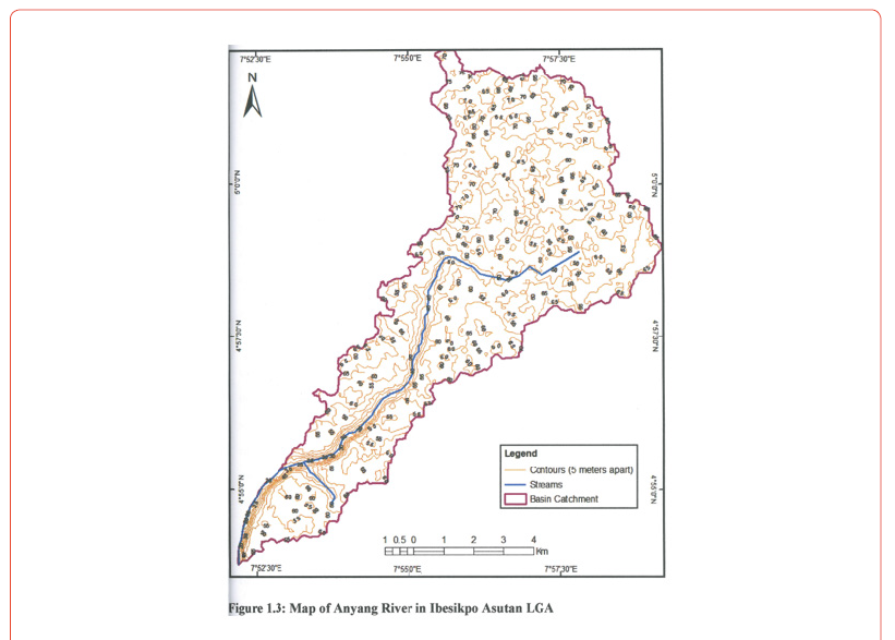
Source: Geographic Information System Laboratory, University of Uyo, Nigeria (2025)
Results and Discussion
Channel Hydraulic Parameters in Anyang River
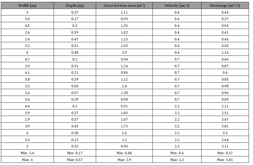
Table 4.1 shows that channel parameters like discharge increases downstream from a minimum of 0.3m3/s along the reach sampled to 3.81m3/.
Table 4.2, summarizes the mean, coefficient of variation from the mean along with the standard deviation. From the figure, the mean of discharge is 1.41, variance 1.29 and standard deviation 80.59. The mean for velocity, is 1.1 with coefficient of variation of 73.35 and standard deviation of0.8. Depth has a mean of 0.3, coefficient of variation of 38.39 and standard deviation of 0.14. Width with mean of 3.7, has coefficient of variation of 29.91, and standard of variation of 1.0, and cross-sectional area has mean of 1.2, coefficient of variation of 35.26, and standard deviation of 0.4. Variance and standard deviation are a measure of deviation of distribution of observations from the mean, while the coefficient of variation measures changes in observation. Thus, parameters with high coefficient of variation and standard deviation show high variability, or change. Thus, from the summary of table 4.2, channel width, shows least variability, followed by the cross sectional area and channel depth. However, the most variable parameter is channel discharge, and velocity.
Table 4.1:Channel parameters characteristics of Anyang River.
Source: Field survey (2025)
Table 4.2:Summary of statistics of channel characteristics of Anyang River.

Number of observations = 21.
Source: Field survey (2025)
Channel Width and Discharge
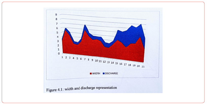
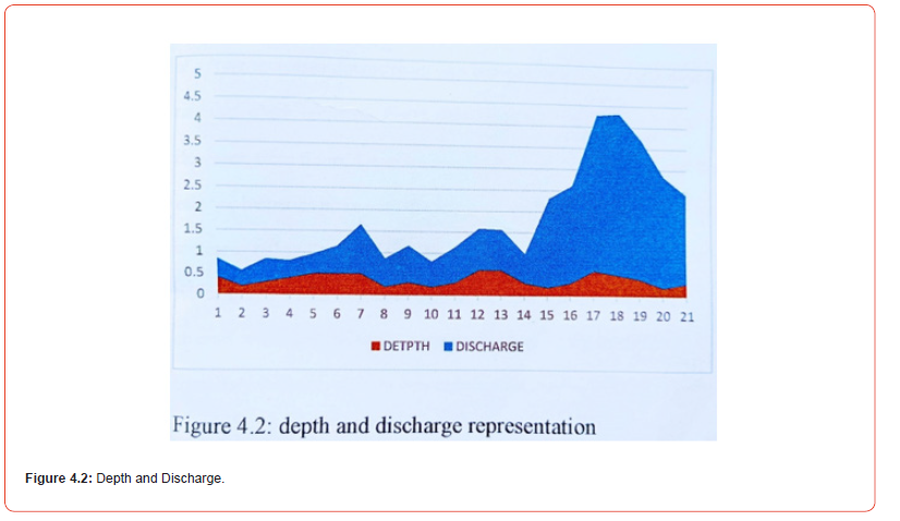
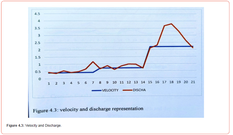
The velocity discharge diagram of figure 4.3 shows velocity increasing downstream as does discharge at a higher rate than all other parameters. By conventional understanding, in river basin studies, especially hydraulic geometry, it is conceived that all hydraulic parameters of a river increase downstream that is from the source of the river to the mouth and follows the rule that width increases faster than depth and the later increases faster than channel velocity.
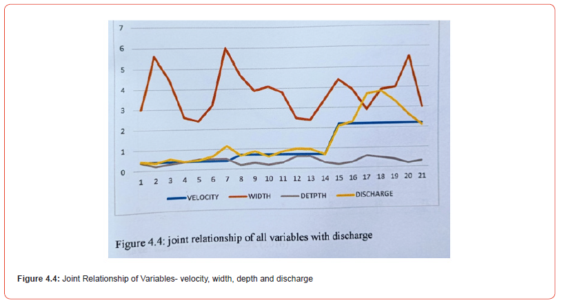
However, from figure 4.4 which shows the joint relationship of all the parameters with discharge, velocity increases more with discharge downstream than any other parameter. Although the width increases rather slowly, along the channel reach, the discharge graph is seen cutting through the width graph which indicates that at that particular reach, channel discharge exceeds bankful channel width and the area is prone to erosion. At the same time, channel depth tends to maintain constancy with only a slight decrease downstream.
Source: Field survey (2025)
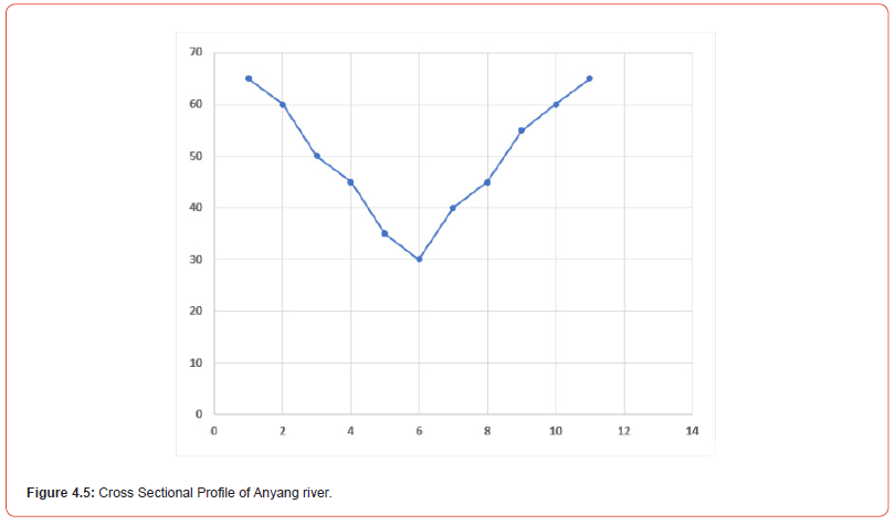
The cross-sectional profile of a river depicts the width and depth of the river at a specific area. The cross-sectional area of the channel taken at Ebere Otu and represented below shows a V-shaped cross-sectional area which is identical with channels along the source of the river characterized by steep slope and narrowed river bed (figure 4.5), and Anyang River satisfies these criteria being a second order stream of Kwa Iboe River. The V-shape of the cross section reveals steep channel slope, which depicts the river is located upstream, with increase bank roughness.
Statistical modelling: Relationship between Channel Discharge and Width

The relationship between channel discharge and width was computed using linear regression analysis as shown in the figure (4.6) below. Channel width was plotted against discharge as dependent and independent variables respectively. A correlation coefficient of 0.33 was obtained from the SPSS analysis (see appendix) which implies a weak but positive relationship. The result revealed that only 7% of changes in channel width is influenced by the total channel discharge. Regression analysis obtained revealed that the effect of discharge on channel width was not significant with the regression coefficient of 0.07 when tested with the 95% confidence interval. At a standard p value of 0.000, H1 is rejected and Ho accepted that there is no statistically significant relationship between channel width and discharge in Anyang River.
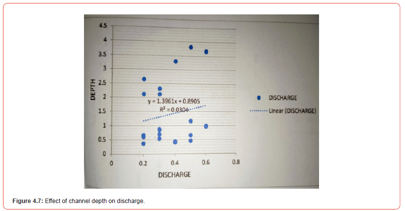
The relationship between channel depth and discharge was computed using linear regression analysis. Scatter plot of depth were plotted against discharge as shown in figure 4.7. SPSS analysis with Pearson’s product moment correlation gave a correlation coefficient of 0.16 denoting a weak and positive relationship. The regression analysis also shows no statistically significant relationship between depth and discharge. Therefore, Ho is accepted that there is no statistically significant relationship between channel depth and discharge.
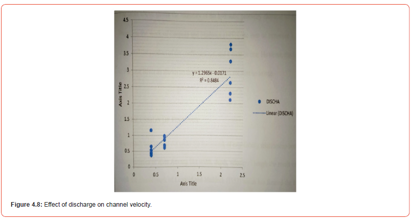
From Figure 4.8 below, the scatter plot shows high correlation coefficient between channel velocity of Anyang River and discharge. A regression coefficient of 0.96 was obtained using the SPSS analysis. The high correlation and regression coefficient occurring between velocity and discharge suggest that there is a significant relationship between channel velocity and discharge in the study area. When tested using 0.05 level of significance, the relationship showed a very high and significant relationship (p value-0.000). Therefore, based on the result so obtained the null hypothesis Ho was rejected and H1 accepted that there is a significant relationship between channel velocity and discharge in Anyang River.
Table 4.3:summary of hydraulic geometry characteristics of Anyang River..

Source: Researcher’s Analysis (2024).
Table 4.3 shows the summary of the hydraulic geometry characteristics of Anyang River. Based on the work of [9], the sum of exponent b, f, and m must be unity, and the product of the coefficient a, c, and k must be one. However, the hydraulic geometry of Anyang River as shown on the table above does not sum up to one..
Discussion of Findings
This result was carried out under the framework of establishing relationship between the channel characteristics of river Anyang particularly width, depth, velocity. Though the result of the study varies with the classic work of [9] which has formed the basis in hydraulic geometry studies, it corroborates with the works of other researchers like [13].
The study had three objectives, and one of such was to determine the relationship between channel width and discharge. The result showed that in the study area, there exist no statistically significant relationship between channel width and discharge. The regression coefficient of 0.07 indicates that only 7% of the channel width is determined by discharge. The b value of 0.08 aligns with the work of [13] who found that for a river with steep gradient, the b value ranges from 0.00< b < 0.82. The influence of riparian vegetation and human modification of river channel like sand dredging, exerts influences that cannot be overlooked [26,27]. While the earlier increases channel roughness reduces susceptibility to bank erosion, anthropogenic influences cause anomalies that might induce bank flooding.
The objective regarding the relationship between channel depth and discharge reveals a weak, positive relationship between the parameters. The correlation value and regression coefficient of 0.16 when tested at the 0.05 level of significance reveals no statistically significant relationship between the two values. The result suggests that with increasing discharge, channel depth increases but a very insignificant rate.
From findings of the study, significant relationship exists between channel velocity and discharge. Both the correlation and regression analysis show high coefficients of 0.92, meaning that discharge determines about 92% of total velocity. It could therefore be inferred that in the upper stream of Anyang River, the dependent variable in regards to flow adjustment and channel cross section is the velocity.
Based on the objective regarding the cross profile of the river, the V-shape form of the cross section reveals that the river is located at the source, the narrow shape of channel width shows bank erosion is minimal, although bed erosion would be expected to increase, the result of channel depth indicate that the nature of bed materials likely contributes to erosion resistance.
Concluding Remark
Hydraulic geometry is an important aspect of investigation
in flood control, hydraulic engineering, hydrology and watershed
management. The study focused on dynamics of Anyang Subcatchment
of Kwa Iboe River. The analysis of different channel
characteristics that inter-relate to shape the channel morphology
has been studied. The findings of the study not only show the
interdependence of the variable acting within and outside the
channel as the river system strive to maintain equilibrium, but
also it depicts the effects of modifications by external forcing like
anthropogenic activities. The dynamics of river systems are affected
greatly by human interventions either within the catchment or
directly within the river corridor threats like sand and gravel
mining. Environmental degradation caused by human interventions,
channelization and other forms of regulations /modifications that
affect morphological character of rivers are essentially continuous,
or press events. These require much more effort to address, and that
the principles of ecology and geomorphology should be considered
or viewed seriously while designing conservation and management
strategies of these life-sustaining systems. It is suggested that:
• Regular studies of river characteristics should be made in
order to allow for availability of river parameters data.
• River monitoring system should be made to understand the
factors that are responsible for channel modifications.
• Modern concept and techniques should be developed in order
to localize river studies.
• Environmental Monitoring should be done before embarking
on any project in or along the river channel.
• Government and legislative body should regulate harmful
anthropogenic activities on the river system.
Acknowledgment
None.
Conflicts of Interest
No conflicts of interest.
References
- Fashae OA, Faniran A (2018) Downstream Characteristics of the Alluvial Section of Lower River Ogun, Nigeria. Journal of Environmental Geography 8(1-2): 1-10
- Abua MA, Aaron TU (2021) Hydraulic Characteristics and Relationship of the Oromineke Catchment in Diobu, Port Harcourt, Rivers State, Nigeria.
- De Rose RC, Stewardson MJ, Harman C (2017) Downstream hydraulic geometry of rivers in Victoria, Australia. Geomorphology 99: 302-316.
- Lee SJ, Julien PY (2020) Downstream Hydraulic Geometry of Alluvial Channels. Journal of Hydraulic Engineering 132: 1347-1352.
- Udosen CE, Udoidiong OM, Eduok E (2018) Downstream Hydraulic Geometry of Enyong Creek; Its Implications on Surface Water Quality.
- Aisuebeogun AO, Ezekwe IC (2019) Channel Dynamics and Hydraulic Geometry of Two Tropical Deltaic Catchments in Southern Nigeria. Landform Analysis 27:3-13.
- Miller JR, Kochel C (2019) Assessment of Channel Dynamics, In-Stream Structures and Post-Project Channel Adjustments in North Carolina and Its Implications to Effective Stream Restoration. Environmental Earth Science 18: 237-249.
- Udosen CE, Etok AS (2016) Morphometric Analysis of Lower Anyang Creek Basin, SE Nigeria; Its Implications for Applied Studies. Online Journal of Applied and Theoretical Environmental Sciences. India. 1: 1.
- Leopold LB, Maddock T (2020) The hydraulic geometry of stream channels and some physiographic implications, U.S. Geological Survey Professional Paper 252.
- Singh VP (2021) On the theories of hydraulic geometry, International Journal of Sediment Research 18: 196-218.
- Yuce MI, Musa E, Muratoglu A (2015) Determining the Hydraulic Geometry Parameters of Seyhan River. American Journal of Engineering Technology and Society. 2(4): 77-84.
- Muratoglu A, Yuce IM (2017) Determination of the Downstream Hydraulic Geometry Parameters of Tigris River. Proceedings of International Conference on Sediment Transport Modeling in Hydrological Watersheds and Rivers, Istanbul, Turkey. pp. 557-562.
- Nanson GC, Nanson RA, Huang HQ (2022) The hydraulic geometry of narrow and deep channels; evidence for flow optimization and controlled peatland growth. Geomorphology 117: 143-154.
- Alexander JS, Zelt RB, Schaepe NJ (2016) Geomorphic Segmentation, Hydraulic Geometry, and Hydraulic Microhabitats of the Niobrara River, Nebraska - Methods and Initial Results. US Geological Survey.
- Costigan KH, Daniel DM, Perkin JS, Gido KB (2018) Longitudinal Variability in Hydraulic Geometry and Substrate Characteristics of a Great Plains Sand-bed River.
- Leclerc R, Lapionte M (2020) Hydraulic Geometry of Alluvial Rivers in The Bois-Francs Region of Southern Qué Canadian Water Resources Journal / Revue canadienne desressources hydriques 19(3): 237-252.
- Frings RM (2016) Sedimentary characteristics of the gravel-sand transition in the River Rhine. Journal of Sediment. Resources 81: 52-63.
- David GC, Wohl E, Steven E, Yochum P, Brian B (2021) Controls on At-A-Station Hydraulic Geometry in Steep Headwater Streams, Colorado, USA. Earth Surface Processes and Landforms. John Wiley & Sons, Ltd. DC.
- Nanson GC, Pietsch TJ (2019) Bankfull Hydraulic Geometry; The Role of In-Channel Vegetation and Downstream Declining Discharges in the Anabranching and Distributary Channels of the Gwydir Distributive Fluvial System Southeastern Australia. Geomorphology 129: 152-165.
- Okon AB, Ikebude CF (2017) Hydraulic Characteristics of Ikpa River in South Eastern Nigeria: At a Station Hydraulic Geometry. Journal of Emerging Trends in Engineering and Applied Sciences (JETEAS) 6(3): 204-211.
- Tabata KK, Hickin EJ (2022) Intra channel hydraulic geometry and hydraulic efficiency of the anastomosing Columbia River, southeastern British Columbia, Canada. Earth Surf Proc Land 28: 837-852.
- Ralph TJ, Hesse PP (2015) Downstream hydrogeomorphic changes along the Macquarie River, southeastern Australia, leading to channel breakdown and flood plain wetlands. Geomorphology 118: 48-64.
- Udosen CE (2016) Environmental Management Plan of Anyang River.
- Smith LC, Pavelsky TM (2019) Estimation of river discharge, propagation speed, and hydraulic geometry from space: Lena River, Siberia. Water Resources Research pp. 44.
- Montgomery RM, Grant KB (2021) Downstream Variations in The Width of Bedrock Channels. Water Resources Research 37(6): 1841-1846.
- Green KC, Brardinoni F, Alila Y (2016) Channel morphology and bed-load yield in fluvial, formerly-glaciated headwater streams of the Columbia Mountains, Canada. Geomorphology 188: 96-109
- Huang HQ, Nanson GC (2018) Vegetation and channel variation; a case study of four small streams in southeastern Australia. Geomorphology. International Journal of Physical and Human Geography 1(3): 20-30.
-
Jimmy UJ*, Abraham CM, Osogi MA and Chrysoula Pantsi. Indepth Analysis of Channel Dynamics and Hydraulic Geometry in Anyang Sub-Catchment, Kwa Iboe River Basin, Nigeria. Adv in Hydro & Meteorol. 3(1): 2025. AHM.MS.ID.000553.
-
Hydraulic geometry, Global positioning system (GPS), Anyang River, Streams, Water irrigation, Pollution, Dams, Barrages, Engineering structures, Environment, Ecology, Geomorphology
-

This work is licensed under a Creative Commons Attribution-NonCommercial 4.0 International License.


